| SGL211-Lebanon Reservoir-Sharp Mountain Loop |
|
|
I'd
like to thank Travis Fuhrman for finding a trail that allows the
hiker to avoid wading the spillway at the end of this hike and
for Bill Mauer for taking the time to map the modified route. Description: I had previously hiked most of the prototypical Saint Anthony Wilderness hikes - The Stone Tower, Rausch Gap, Old Horse-Shoe Trail, etc � and was looking for something novel, not charted in any of the modern day books and maps, when Bill Maurer, a Reading, PA resident stumbled upon this gem. Immediately after reading his trip report on Backpacker.com and studying his data I asked if he would co-lead a spur of the moment Sierra Club outing and he agreed. Needless to say I was very impressed. Now, please don't get me wrong. Members of the Susquehanna Appalachian Trail Club (SATC) do a bang up job maintaining the Saint Anthony's Wilderness Trails in the main section of SGL211 west of Gold Mine Road but I find hiking the trails on the east side a step above them ... that is with a couple of caveats taken into consideration. They are: |
|
1) there will
be the possibility of up to three technically challenging stream
crossings. On at least one your feet will always get wet.
Alternate footwear might be in order. 2) The red blazed Black Spring has been abandoned. Although "easy" to follow it is badly eroded in places and the central section is littered with blowdowns. It will be the most challenging one mile of the day. Directions to alternate parking areas making it pretty easy to set up two different shuttles instead of the primary hike are provided. Google Maps Custom Driving Directions to the Primary Start Point at the end of Old Forge Road Google Maps Custom Driving Directions to the Box Car Rocks Parking Area on Gold Mine Road ________________________________________ |
|
Zipped National Geographic TOPO! GPS and Universal GPX Files |
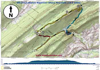
Trail Notes: The primary loop (all caveats included) is 10.3 miles in length. The first shuttle is 7.3 miles in length but includes most of the highlights. The second shuttle is 9.9 miles in length and includes all of the caveats except for the final climb down from the dam and the crossing below the spillway.
Trails are not signed but are quite obvious. Only the abandoned Black Spring Trail is blazed � old, infrequent and faint red.
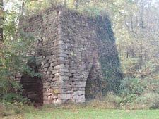
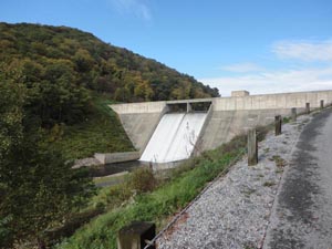
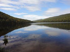
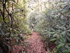
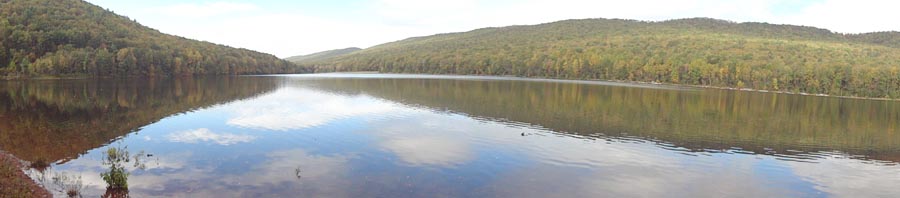
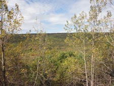
From the parking area walk around the gate and pass an old iron furnace on the left. Bear right where the service road splits and climb to the top of the dam. A footpath follows the anchor fence into the woods. The trail is apparently maintained and easy to follow. The forest type here is mostly hardwood with a sprinkling of eastern hemlock. As you proceed more and more rhododendron will enter the picture until you finally find yourself walking through wonderful tunnels of the stuff. It must be a sight to behold in late June through July. At 0.5 miles the trail splits (but soon reunites). I recommend taking the left fork to obtain nice views of the impoundment. In another 0.6 miles another obvious trail comes down from the right in a gap on Second Mountain. Continue straight. After you cross a small stream the trail joins a wide woods road encapsulated in rhodos. At this point you have pretty much passed the reservoir but will soon hear the waterworks of Fishing Creek. |
|
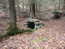
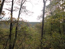
Eventually you will ford it. Here the forest type totally changes into a canopy of hemlock with an understory of moss covered boulders. Make sure you explore the walled spring to the left of the trail in 1.5 miles from the last described trail junction. In less than 0.1 miles turn left onto another woods road. Initially it also serves as a stream as water flows from abandoned coal mines far above you. Here you�ll climb about 700 feet over 0.8 miles through typical Mid-Atlantic hardwood forests. The rate of climb is eased by a switchback near the midpoint. You know you are near the top as you pass the first of several strip mines that you will encounter on Sharp Mountain. There is a nice break spot above it with a window view to the south. The next few miles of hiking will be on a relatively flat and grassy lane of sorts. To your left will be cavernous trenches left over from the mining days, exposing rather imposing rock faces. And of course, to the right of the trail you�ll find the prerequisite tailings piles, one for each trench. One may consider these to be eye sores but my Mom always told me you have to look for the good in the bad, especially in these cases since the piles aren�t going away anytime soon. So here are three good things about these tailings piles:
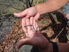
1) They create nice viewing platforms from which to observe Stony Mountain and more distant ridges as well as soaring birds of prey. 2) It�s a great place to find your favorite serpent sunning itself. 3) You don�t have to kick the slivers of rock and coal around much to find an assortment of prehistoric fossils.
There are several of these piles to explore but the best one is 0.9 miles from the break spot. Eventually signs of strip mining will cease. Now you will pass red pine plantations on the left and scrub growth on the right. This area was obviously surface mined. During this process the earth is removed and spread out elsewhere no to far from the site, probably where the red pine was planted in an attempt at reclamation. A thin seam of coal was then scraped up and what was left was no more than a rocky barren of sorts. An oddly placed line of towering Norwegian spruce seem to mark the northern boundary of �the mine�. In 2.2 miles from the marked tailings pile turn left onto a trail that leads through one of the red pine plantations to visit Boxcar Rocks. I�ve been told there is a view from the top but I didn�t check it out. It�s quite the rock scramble.
If doing the short shuttle return to the main trail and turn left. In 0.2 miles find yourself at the parking area on Gold Mine Road and your plant vehicle(s). If doing one of the longer versions turn left on the road and just as you reach the first set of guard rails walk around a rusty forest gate on the left. Follow a grassy and perpetually wet pipeline for 0.2 miles. It may be overgrown in places. Turn left at a rock cairn to pickup the abandoned and red blazed Black Spring Trail. Keep in mind caveat #2 as you proceed down this one mile trench. (You will swear it is longer than that when you are finished with it.) I know it might be difficult but take time to at least realize that you are walking through another beautiful hemlock forest with moss covered boulders strewn about. As the trail mellows out be on the lookout for a set of double blazes. It doesn�t matter if you miss it as the trail soon swings back to the old skid road just before reaching Evening Branch. When we explored the area the water was knee high but gently flowing. Bill tells me that it is nearly always this way. Immediately after the ford the road disintegrates. At this point its location is no longer important since the railroad grade you seek can be seen through the open woods, even in the summer.
If undertaking the second shuttle turn right onto the grade and follow it for 1.4 miles to reach Gold Mine Road and your plant vehicle(s). To complete the loop turn left. For the next 1.2 miles you�ll get glimpses of the reservoir to the left and the shade of even more hemlocks to the right. The grade is gated near its end and signed �No Trespassing�. Follow a narrow footpath to its left until you reach the top of the dam. As the fence descends steeply to the left, towards the spillway, turn right and follow a faint trail uphill to the tree line where it turns left and becomes more obvious. Follow it as it descends slowly, arriving at a drive way and two buildings. Follow the drive out to the main service road and return to your vehicle.
________________________________________
________________________________________
Name: iwtrekpa Hike: Lebanon Reservoir - Sharp Mt Date: 05/25/13 Rating: 4.6
Critique:
This
hike was posted previously about 2 years ago as a new hike but
has been changed slightly since that time. The now posted red
blazed Black Spring trail that you pick up off the end of the
state game land road(where box car rocks/chinese wall branches
off) used to follow the gas line the whole way down to Evening
Branch creek. I haven't tried to find this trail but I can tell
you following the previously posted gas line down sharp mountain
was super wet and sloppy and the trail was like a deer trail
that at times I literally was crawling on my hands and knees to
navigate thru. Whether navigating the gas line or following
Black Spring trail, the challenge at the bottom is finding a way
to cross Evening Branch without getting soaked (you will get
soaked). ________________________________________ |
|
|