|
Laurel Fork Backpack |
|
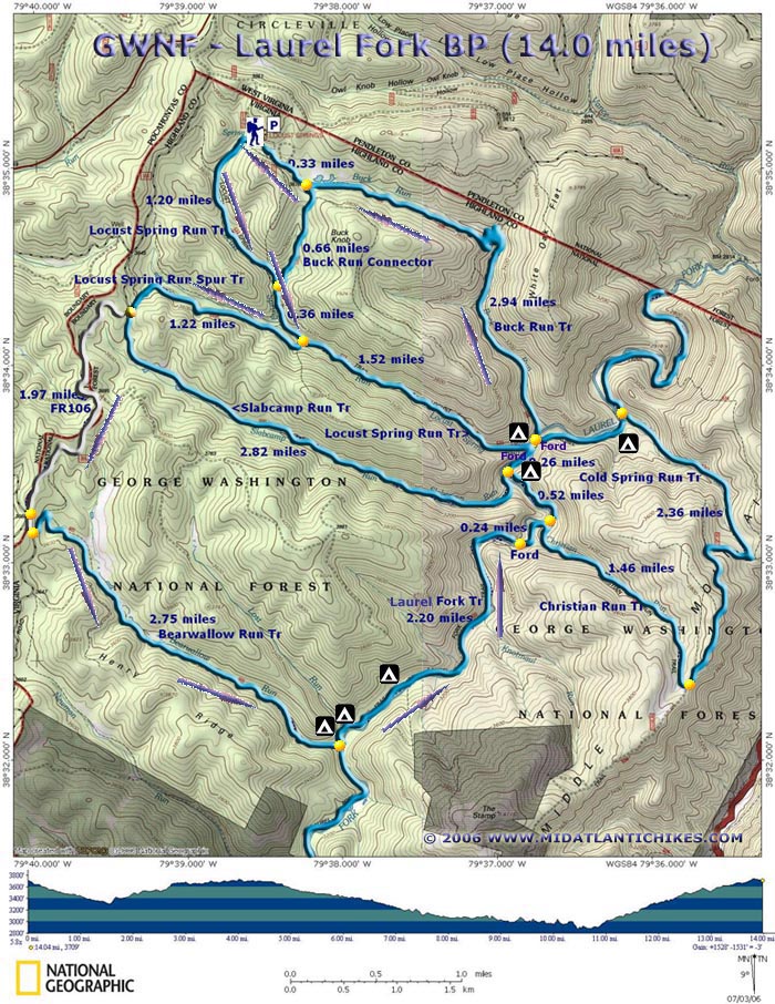
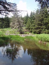
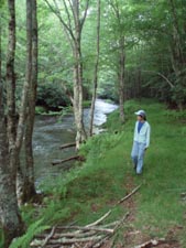
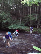
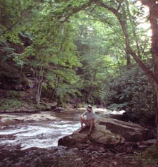
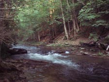
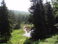
Description: The Laurel Fork trail system is a Special Management Area of the George Washington National Forest located on the VA/WV border. With elevations up to 4000 feet the forest supports vegetation more commonly found in our Northeastern states and Canada than in a central Appalachian forest. Beautiful stands of Red Spruce and Red Pine as well as different birch species can be found scattered among the more common Oak, Beech, Hemlock and Maple. The upper portions of all of the stream valleys support large meadows formed by beaver dams, past and present. Laurel Fork, a tributary of the Potomac River, is the focal point of the area. The trail along it is in rough shape but can still be followed by the experienced hiker with the proper map. The solitude and beauty that it offers is well worth the effort. This venue contains 28 miles of hiking trails, most of which are either old logging railroad grades or footpaths leading to them. For the most part any elevation change is usually pretty gradual except in a couple of cases. The hike described here is a moderate 14 mile backpack. Two miles are along a forest road but good time can be made along that segment. Several campsites are shown which will allow you to adjust the mileage covered each day to suit your needs. |
|
More information about Laurel fork can be found at this Warm Springs Ranger District link. Google Custom Directions
________________________________________ |
Zipped National Geographic. TOPO! GPS and Universal GPX Files |
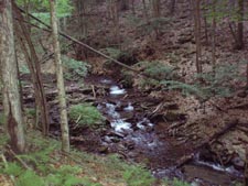
Trail Notes: All trail junctions are signed. All blazes are blue but are faded and infrequent. As you face the picnic area the Locust Spring Run trailhead is to the right. It begins as a grassy woods road. Descend through a mixed Hemlock and Red Spruce forest. In 1.20 miles pass the junction with the Buck Run Connector on the left. Continue downstream. Cross Locust Spring Run and then a tributary that comes in from the right in another 0.36 miles. There will be an old sign strapped to the post for Locust Spring Run Tr. Continue downstream and merge onto a railroad grade. In about 200 yards arrive at the junction of the Locust Spring Run Spur trail on the right. Turn here and climb steeply to another railroad grade. From here the grade is pretty gradual. Follow the grade for about 1.1 miles. Towards the end you will be able to see an old beaver pond down in the valley. Keep a sharp eye out for a footpath on the left. It is blazed and has a small arrow sign. Take it to the junction of Slabcamp Run Tr and Fr106. Turn left onto FR106. (This forest road is open to public access so walk single file on the side facing traffic.) In 1.97 miles pass the intersection with FR57 and FR58 on the right. Soon turn left onto signed and gated Bearwallow Run Tr. Initially the trail switchbacks gradually through a hardwood forest but soon finds itself tracing the edge of beaver meadows and ponds surrounded by Red Spruce. The trail will weave in and out of a couple of small side coves, one with two small bridges, before it begins to parallel the run. It will eventually connect to a railroad grade. Watch out! After about one mile the tread leaves the grade to the left and descends to the stream on a footpath to yet another RR grade. Follow this a short distance to the junction of the grassy Laurel Fork Tr and a small campsite. At this point you have hiked 7 miles. |
|
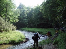
Turn left (downstream) and cross Bearwallow Run where you will find yet another small site. Immediately turn left as if you were going to follow the run and walk up through the remnants of a grassy road and watch out for a footpath on the right. It is buried in a thicket but it is there and marked by a very faint blaze on a tree. Turn here and again find yourself on a wide trail that parallels a Rhododendron thicket along the Fork. There are a couple of small campsites nestled in it. Continue downstream. In about 0.6 miles pass a huge campsite on the left. This is the last established campsite for the next 3 miles and there is some rough going and a ford of the Fork to negotiate before reaching the next one. There is a couple of grassy areas along the next mile of the trail that might do in a pinch but plan on getting a good workout before the next established site. After this last campsite the condition of the trail degrades rapidly. It will alternate from nice and grassy, to weedy and boggy, to hiking through Rhododendron tunnels and then holding on to the side of the bank where the Fork has washed away the old jeep road. At times You may think that the trail has crossed over to the other side and that you have missed the ford but you haven�t. At 2.2 miles from leaving the Bearwallow Run Tr the trail stops. If you look downstream you�ll notice that the valley on your side becomes almost a shear drop off. Look across the Fork. You�ll see what appears to be a small beaver slide tucked under the Rhodos. That�s the continuation of the trail! Switch to your stream crossing footwear and ford the Fork. Once on the other side walk through another Rhododendron tunnel. In 0.24 miles cross pretty little Christian Run and pass the junction with the trail of the same name on the right. This portion of the Fork is very scenic with flat rocks jutting out into it. Follow the rocks around the bank to pick up the trail on the other side. In 0.52 miles from Christian Run arrive at the junction of Slabcamp Run Tr. There is an old sign in a weedy clearing. (The ford for this trail has actually been relocated. It is now a few yards behind you. There is a new USFS sign on the opposite bank at that location.) Continue through this weedy area to arrive at a very large and grassy campsite surrounded by Rhodos and shaded by large trees. At this point you�ve covered about 10.5 miles. The next ford of Laurel Run is another 100 yards further downstream. Once across the Fork the rest of the trails you�ll be using are in pretty good shape. In another 0.26 miles cross Locust Spring Run. There are a couple of nice campsites here. The tread picks up an old railroad grade and begins climbing gradually above the Fork. In a couple of hundred yards the Laurel Fork Trail turns right on a footpath. There are other campsites on the other side of this ford. You don�t want to turn here but stay straight on the railroad grade which becomes the Buck Run Tr at this point. The grade will soon bend away from the fork and begin to follow picturesque Buck Run with its small falls and chutes. The grade is pretty gradual and requires little exertion. At about one mile cross a small stream and climb steeply for a short distance. In another 0.5 miles you�ll come to what appears to be a fork in the run. Cross the first fork, turn left and follow the blazes upstream. Soon come to a crossing made obvious by the placement of 3 logs to form a crude bridge ( really not needed most of the time) and a rock cairn on the other side. Re-cross the fork here and turn left at the cairn. In a few yards the trail will veer hard right and begin climbing high above the run via several well-placed switchbacks until it reaches another railroad grade. Follow the railroad grade. The next mile is nearly flat. At the end of the grade you�ll walk through a towering Red Pine plantation which borders a beaver pond on the right. As the trail curves around the pond it will climb slightly to give you a grand view of the pond from above. Soon reach the junction of an old woods road. To the left is the Buck Run Connector. Turn right and in 0.33 miles arrive at the end of FR142. Turn left and in a few footsteps arrive back at your car. Printable/Downloadable Directions and Trail Notes ________________________________________
________________________________________ Name: JNK556 Hike: Laurel Fork Backpack Date(s): 10/17-18/14 Rating: 4
Critique: Did
this hike as posted with Arfcomhkr, and one other friend.
Trails were clearly marked, and for the most part in good shape
except for parts of the Bearwallow trail, which is poorly marked
in spots, and narrow and rough. The small connector trail where
the Locust Springs Spur, cuts from the RR grade, and connects to
the forest road is hard to find, we ended up missing it, and
just bushwacked the 100yds up the hill to the road. Rest of the
hike was nice, except for the high winds that kicked up our
night on the fork. Laurel Fork trail looked to have been
recently blazed, and had zero trouble following it. Two tough
spots where the RR grade has been washed away, and you're trying
to tiptoe through were pretty tough, but not impossible.
Crossings weren't too bad, water was up just a bit, and running
fast, but nothing over knee high. Hike out on Buck Run was
long, and in some places pretty strenuous, but we've hiked
worse. All in all good trip, the bad spots on the fork give it
a 4 out of 5 rating. ________________________________________
Name: Lacy Hike: Laurel Fork Backpack Date(s): 08/30 to 09/02/13 Rating: 4
Set out early in the morning for a 2 night backpack. The directions were incredibly specific and easy to follow. We didn't get lost even with my complete lack of navigational skills. Some things to note, in the 3rd paragraph of the instructions, when you're looking for the footpath on the left with the small arrow sign--the tree marked with the blaze has fallen down across the path and the sign has come off the tree. We leaned the blaze against the fallen tree, but this may not be a lasting solution. We came across the rattlesnake area, but found the sign (still there!) after passing the "danger zone", so I guess we were walking the opposite direction of the hiker who posted the sign. We didn't see any snakes or signs of snakes here, but just be careful when you start walking on the rocks by the stream. The only snake we saw was a brown unidentified snake on the rocks prior to this area near where the trail erosion was. We saw him as we were trying to avoid a large fishing spider sunbathing with a full egg sack on the rock we were trying to cross. Strangely enough, these two were the only animals we saw on the trip (minus an alleged deer sighting by my partner and the millions of gnats constantly swarming us). It was quiet hike through the woods, rarely even heard birds. Only saw two other groups of hikers on the trail throughout the entire 3 days. Campsites are nice, some have seats built of river stones (some with backrests!) and most sites had extra wood the previous hikers hadn't used still sitting next to the fire pits. We really enjoyed our time out in the woods. Recommend bringing two pairs of shoes as we used one for hiking all day and crossing the rivers, but had a second pair at night for around the campsite. Thanks for the great directions and reviews! We will be using this site for camping trips in the future! ________________________________________
Name: Ben Hike: Laurel Fork Backpack Date(s): 06/29-30/13 Rating: 4
Critique: Three of us did the hike as described the last weekend of June, 2013. The area was beautiful and like much of that area looked more like Canada or New England in places. For the most part the trails were in good shape. The two exceptions were the Bearwallow Trail and a few parts of the Laurel Fork trail itself. The upper portion of the Bearwallow was hard to follow. The blazes were faint and the path was almost non-existent in the beginning. The trail does improve once you get on the grade by Bearwallow Run but be prepared to spend some time in the beginning looking for blazes. The Laurel fork trail was for the most part in great shape as it was worked on a couple years ago by the student conservation association. It had nice fresh blazes and they cleared out the rhodos. The only bad part was a couple sections where the side hill had washed out forcing one to walk in Laurel fork a little ways. The campsite by the intersection of the Laurel fork and locust run trail was great though. ________________________________________
Name: Bob Handelsman Hike: Laurel Fork Backpack Date(s): 06/19-22/13 Rating: 5
Critique: A few years ago, I did a post for this hike which I did in 1978 and again in 1979. I always wanted to go back and finally did -- after 34 years. It took us, a 54 year old, a 60 year old and a 65 year old, about 2 1/4 hours to hike down the Buck Run Trail and set up a base camp on the flat ground near the confluence of Locust Spring Run and the Laurel Fork. There are a number of very good campsites there. If you want to cross the Laurel Fork Trail and hike the trail there, it looked easier to cross by the campsite closest to the Laurel Fork and, if going north, easily bushwack over to the trail. The trail going north only goes to the Cold Spring Run trail which is a nice walk but no views on the top. Going south, there are 2 good campsites after crossing the Laurel Fork about 100 yards south of Locust Spring Run. We met a local guy who said he caught about 25 brook trout in the Laurel Fork in an afternoon, the biggest about 13 inches. To fish the Laurel Fork effectively, one needs wading boots for ankle support and a wading staff. CAUTION: IF GOING SOUTH (UPSTREAM) ON THE LAUREL FORK TRAIL, THERE IS A RATTLESNAKE DEN DIRECTLY ON THE TRAIL ABOUT 2/5 MILE SOUTH OF LOCUST SPRING RUN. AT THIS POINT, THE TRAIL GOES DOWN TO THE RIVER AND IS MARKED BY 2 ROCK CAIRNS. THE DEN IS BETWEEN THE 2 CAIRNS UNDER A LEDGE/STEP. When we were there, someone stuck a note on the first cairn warning of 2 "big" rattlesnakes and we saw a shed snake skin estimated at 3 feet in length. The note may not be there for the next hiker.
________________________________________
Name: Matt
Hike: Laurel Fork ________________________________________
Name: Bob
Handelsman
Hike: Laurel Fork ________________________________________
Name: Peter
Schultz
Hike: Laurel Fork Backpack (GWNF) ________________________________________
Name: Tony
Hike:
Laurel Fork ________________________________________ |
|
|