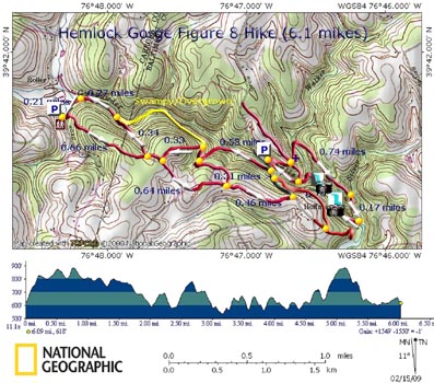
More photos of a 2003 Sierra Club outing

Photos from our 06/12/04 outing

Hemlock Gorge

Last Reviewed: 07/04

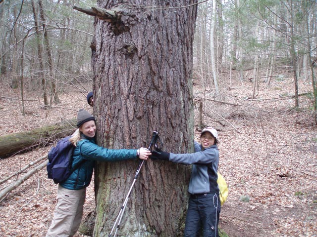
Description: Moderate 6-mile figure-8 circuit hike along the headwaters of the Gunpowder River above Pretty Boy Reservoir. Includes a particularly beautiful rocky gorge full of Hemlocks and cascades. Flora: Spirea, Meadow Rue, and Scarlet Pimpernel. Fungi: Old Man of the Woods, Russula Pulchra, Chicken of the Woods, Coral Mushrooms.


Warnings: There are no blazes or signs on this outing. Follow the directions carefully and be alert. Proceed at your own risk!


A couple of the areas on either end of Hemlock Gorge proper may get overgrown with thorns, Stinging Nettles and Poison Ivy. Wear light weight long pants preferably with zip off legs in the summer.

Google Custom Directions

Th  There will be a pull-over with two trails on the right followed by a corral for River Valley Ranch. Park on the shoulder but do not block the corral gate.

_____________________________________________________

Printable/Downloadable Map

Trail Notes: This is the first hike that I ever scouted alone. Although it is only of moderate difficulty one has to pay attention. There are no signs or official blazes. There are just enough cross trails to confuse you if you are not prepared.

From the parking area, look into the woods alongside of the corral. There is a trail going directly up the hill on your right. There is another trail going straight into the woods paralleling the corral. Take this route. In about 40-50 yards come to a fork in the trail. The left is your return route. Turn right and climb steeply to the top of the hill.

The next leg of the hike is either flat or mostly downhill. Follow this well-worn trail on an old farm road. At approximately 0.6 and 0.8 miles, look for trails to your left. You will use these on your return.

At about 1.2-1.3 miles from the beginning come to Gunpowder Rd. Turn left and walk down the road, staying on the grass shoulder. Cross the bridge over the Gunpowder River. To the left there is a gravel bar that supports a lush growth of tall flowering weeds in the summer. Several species of butterflies and moths can be observed here.

As you continue along Gunpowder Rd look for a trail at a pull-over on the right shoulder. Take this up and around the hill. It will soon become a forest road.

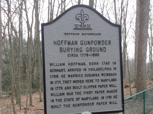
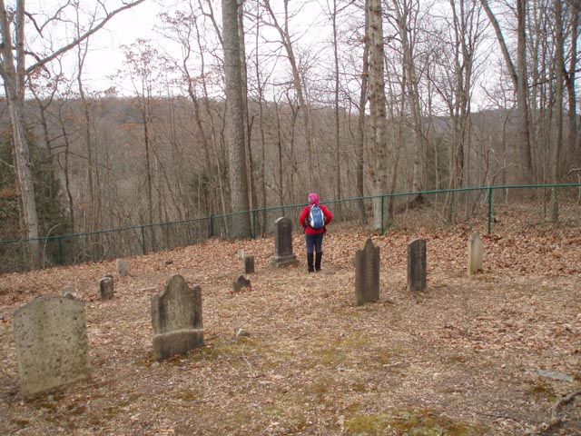
At a four-way intersection (about 0.3 miles from Gunpowder Rd), come to the original Hoffman Cemetery. Buried here is the founder of the Hoffman Paper Mill established in the 1700s along with other family members and servants.

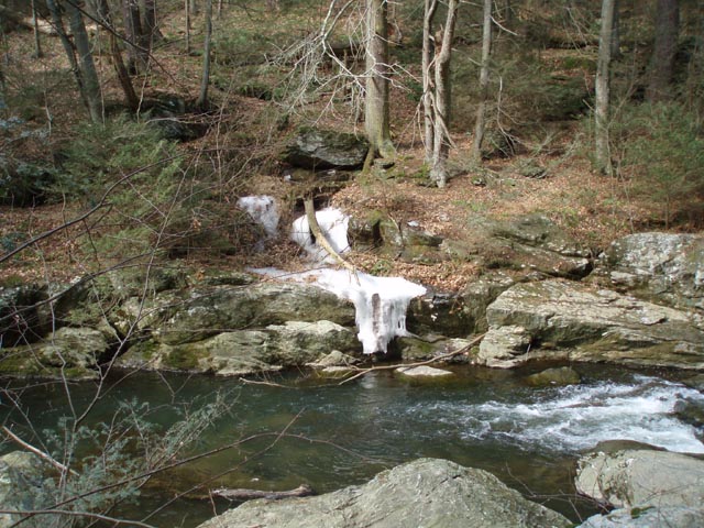
Continue straight through the intersection, down a steep hill, across a stream (Walker Run), up another steep hill and back down to another stream (Silver Run, about 0.5 miles from the cemetery). If you haven't noticed by now there is an abundance of Hemlock trees around you.

If you have a sense for history and a little imagination, cross this last stream and immediately turn right onto another woods road. Follow the stream down to its confluence with the Gunpowder. This is where the Hoffman Paper Mill was located. If you look to the left and downstream you can see a mound immediately in front of you, which is all that remains of the dam. Across the way, in winter, you can see the remains of an old out building. There used to be some old gears and other metalwork in the shallows but that has been recently removed.

Return to the last stream crossing and re-cross it. Follow the other bank downstream on a well-worn trail towards the stream juncture. The trail might get iffy when you arrive at a sandy but very weedy bench along the river. Turn right here and work your way up river until you find the trail again on the other side of the bench.

This is where Hemlock Gorge officially starts. In a few steps you will find yourself in a setting more like that found way up north than below the Piedmont Plateau. You'll be surrounded by close canyon walls, massive gray rocks, Hemlocks, and rushing white water. The trail is well defined at first but sections of it require that you find your way upstream the best you can until you regain the trail. Just don't get too high up on the wall.

In about 0.5 miles from the last stream junction you will come to the confluence of Walker Run with the Gunpowder and
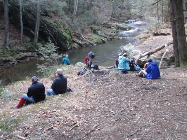
 the old swimming hole. This is one of the best lunch spots in MD on a hot July day!

After you've had your fill of relaxation, grab your gear and continue upriver, arriving again at Gunpowder Rd in about 0.3 miles. Turn left and re-cross the bridge. Immediately after crossing turn right, passing a forest gate, and walk along a forest road. Youll pass through more Hemlocks as you go along.

Near the crest of the hill the road splits. A grassy road goes straight and the main route turns sharply to the right. Make this turn. In a short distance the trail will make a sharp left and start heading down hill. Stop and look for another trail to your left just after your last turn. Make this left turn and walk uphill some more to the intersection of the trail you first started on.

Turn right here but in a short distance make another right on an old woods road that takes you down to the river one last time. Follow the river until you reach another small stream. Turn left on a well-worn footpath and return to your car.

______________________________________

name: Ian                                                                                                                   hike name: Hemlock Gorge

Hikedate: 3/29/05                                                                                                   Ranking: 5

comment: What a great spot, I've lived in the Baltimore area for 30yrs and never knew this was here - Thanks for the tip! On a Tuesday afternoon, I didn't see a soul the whole hike and there was minimal litter or evidence of vandalism. One of the more beautiful spots in MD I've seen. NOTE: in late March 2005, Cotter Road was closed due to construction. From Baltimore, it might be easier (and more scenic) to take Falls Rd N; turn right onto Graves Run; at the intersection with Hoffmanville Rd, continue straight and follow the last step in the directions listed for this hike. Beckleysville Rd also intersects Falls Rd just S of Graves Run so that's another option if you're coming from I83.

Mrhyker note: It seems like every spring now there is a problem with Cotter Rd.

______________________________________

name: Janet                                                                                                               Hike Venue: Hemlock Gorge*

Hike date: several times                                                                                         Ranking: 5

comment: This is my favorite hike in Maryland. The first time you enter the gorge is awesome

_______________________________________

name: Alex                                                                                                                 hike name: Hemlock Gorge*
Hikedate: June 26, 2005                                                                                          Ranking: 2

comment: First off, Cotter Rd. is still closed as of June 26, 2005 and doesnt look like its going to reopen anytime soon. We followed Beckleysville Rd. around for about ten minutes and then took a right on Gunpowder and followed the directions from there. The swimming hole is really nice and is someplace Ill probably go back to in the future but I will not use this hike to get there. If you just want to go to the swimming hole, you can park on the side of the road over a bridge on Gunpowder Rd. past the newer (but still fairly old) cemetery. This is actually where you cross over Gunpowder Rd. on the hike. From there you can go DOWN trails that lead from the bridge to the river and go from there. There are actually lots of cool places to jump in and take a dip or sit on the rocks and relax. We went on a Sunday and saw quite a few people, but one of the locals said that the weekends were the only time you saw a lot of people splashing around. The main swimming hole can be recognized by the presence of a few old ropes that are tied to some trees nearby in what looks like an old attempt to make a rope swing.

The bad news is that this hike isn't all that interesting. The hike is pretty clear before you cross Gunpowder Rd, the bridge, and hit the old cemetery. However, there really isn't much to see except for your typical hardwood mid-Atlantic forest scenery. The hemlocks aren't all that plentiful or impressive. Past the old cemetery the trail is fairly nonexistent at times until you get to the swimming hole. Something else to note is that a LOT of this trail is almost completely covered in stinging nettles and thorny bushes. We went in June and wore shorts and by the time we got to the swimming hole, my hiking partners legs were pretty swollen and cut up, so if youre going to go this route, wear some long pants and think about bringing a machete to cut out a better trail. Also, the way back after crossing over Gunpowder Road is tricky and the directions are a little vague. After taking a right at the crest of the hill, the directions say, In a short distance the trail will make a sharp left and start heading down hill. Stop and look for another trail to your left just after your last turn. What we found were two left turns within ten feet of each other. The first went uphill, the second went downhill. Based on the directions we took the sharp left that went downhill and we ended up in what the creator of this hike labels in yellow on the map as swampy. The map shows it connecting back up to the main return trail, but it doesnt. We got stuck in a bog that basically dead-ended into the river and were forced to turn back. With sunlight fading, we managed to catch a ride with some nice folks back at Gunpowder Rd. so I have no idea if the rest of the directions are accurate or clear. I do know that the directions should be updated and made clearer in regards to the return trip and the left he says to take at crest of the hill you hike up after crossing Gunpowder Road. My impression is that he means the first left that goes UPHILL, rather than the second left that goes DOWNHILL, because I can tell you that the second left that goes downhill leads to a swampy dead-end. I should also point out that at least in June, the bugs are pretty ferocious, so bring some repellent, and something to wave them off and swat them with, because they can be pretty heavy at times. Overall, Id recommend the swimming hole and the river, but this hike is not worth the effort given all the other wonderful hikes in the area.

M. R. Hyker note: Will try to clarify places where Alex made some wrong turns. I'll let the visitor read all of the critiques found here. Everbody sees a hike with different vision I guess. This is viewed by many hike leaders in the Baltimore area as a crown jewel especially being so close to a metropolis.

_______________________________________

Name: Bob Gabbart                                                                                                  Hike: Hemlock Gorge
Date: 1/29/2006                                                                                                      Ranking: 3

Critique: This was one of the better hikes that I have taken within an hour drive of Baltimore. The hike starts with a nice walk in the woods for a couple miles. You then come down to the gorge and walk through it for a mile or so. The gorge is very nice and is the high-lite of the hike. You then return to the woods and then go back down to the river for the last part of the hike. The directions were very good. Inf act, if you do not take the directions, you will get lost on this hike. The map by itself is not good enough. There is just one mistake in the directions. Toward the end where it says "In a short distance the trail will make a sharp left and start heading down hill. Stop and look for another trail to your left..." It should read "...In a short distance the trail will make a sharp RIGHT and start going downhill. Look for a trail to the left. Make this left turn and walk uphill..."

M.R.Hyker Note: I checked my data and I think Bob missed a turn. E-mail me Bob and we'll discuss it but:

After you leave Gunpowder road you walk parallel to the river but pretty removed from it. After a while the old woods road you're on goes straight into a grassy area and you turn right onto another well worn woods road. It follows a seasonal draw on the right. Sometimes it has a stream, other times its dry. As you near the river the road makes a "left" and begins to descend to the river. Right at that bend is another trail on the left that climbs up and over a small hill.

_______________________________________

Name: matt w                                                                                                            Hike: Hemlock Gorge
Date: July 8, 2006                                                                                                     Rating: 3.5
 

Critique: Great hike for being so close to the city. Took me 30 minutes from downtown Baltimore to arrive.

Followed the hike route from the trailhead to the gorge, then decided to take the same route back. The hike into the gorge as per these directions felt almost like a bushwhack, as we were waist deep in grasses and thorn bushes for about a quarter of a mile.

The scenery by this part of the gunpowder is really impressive. Although there isn't a large amount of hemlocks, the ones that are there are absolutely beautiful, with a few of them being absolute giants.

Highly recommended, a great day trip and picnic outing.

_______________________________________

VA Hikes MD Hikes WV Hikes PA Hikes Contact Us Home