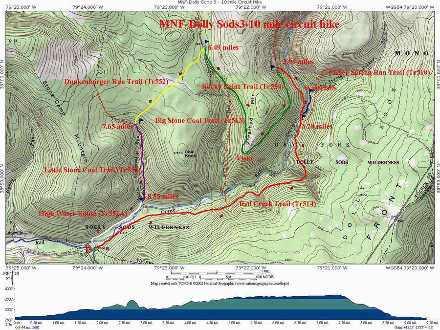
|
Red Creek/Dunkenbarger Loop
|
|
|
Description:
This is a moderate 10 mile circuit hike taking you through
some of the prettiest deciduous and coniferous forests, past
grand waterfalls, if you don't mind bushwhacking, and along
some very tranquil streams. There are a few hard parts. You
will have to negotiate four significant water crossings, at
least two of which will require either alternate footwear or
will leave the hiker walking in wet boots.Rocky Point
trail can be described as nothing other than ... rocky.
Overall, the sacrifices are worth the rewards.
Turn up the driveway for the old Wildlife Management Cabin. Park in
the rear or on the shoulder of the drive. |
|
________________________________________ |
|
Trail Notes: Before starting, take note that there are no blazes in Dolly Sods. Recently, sign posts have been re-installed at all trail intersections. I�ve done this easily as a day trip. Fulya and I did it 2 days after Hurricane Isabel. I knew the water was going to be high so we opted to do the hike in the reverse direction using an old high water route described at the end to avoid the worst stream crossing. It took us a little over 7 hours because we did a lot of bushwhacking to some cool waterfalls and the Lions Head Overlook. Having not been to the latter it took us a while to find the easy passage up. There is so much to explore here and there is such an abundance of good campsites around that a backpacking trip might be the preferred way to go.
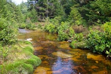
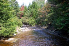
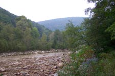
From the parking area, walk up Red Creek Trail. It begins as a wide forest road which stops at a backwater of Red Creek. Cross and immediately turn right on a narrow footpath, following close to the bank. Part of the trail has been blown out. This area will become apparent to you shortly. Bushwhack through this area and pick up a well-defined footpath on the other side. Follow it to a grassy clearing with a trail that comes in on the left. This is Little Stone Coal Trail. You may want to take the short trip out to the crossing to examine the ford for your return trip. If it looks too risky there is an alternate return route that will be described later. |
|
Stay on Red Creek Trail and proceed upstream, first traveling along a railroad grade and then climbing gradually up a footpath. At about 0.91 miles from the junction with Little Stonecoal Trail you will come to a cairn and a trail that goes to the left. This trail ends at a campsite. Continue straight on the main trail. Beyond this point to the left will be a sketchy trail marked with a cairn on the downhill side that descends through the Rhododendron. The trail is hard to find and steep but is a quick connection with Big Stonecoal Trail and the rest of Red Creek Trail. This is a popular campsite.
Shortly after your descent turn upstream (right) at the trail junction sign. You will join an old railroad grade for a while then bear right onto a footpath that will climb up above the creek. In 1.5 miles reach the junction of Fisher Spring Run Tr on the right. Descend to Red Creek. There are several campsites upstream from here on an old railroad grade. Follow it and pick the site of your choosing if you are doing this as an over-nighter. There is also a nice waterfall there. It makes for a good lunch spot. To continue, return to the crossing (marked with cairns), don the footwear of your choice and cross Red Creek. There is another good campsite on a bench sitting above the creek here and another one just a little further up the trail almost directly across from your lunch spot.
Continue up Red Creek trail as it climbs to a junction with Rocky Point Trail (0.7 miles from the ford). Turn left onto Rocky Point Trail. Soon the trail will become quite rocky as it becomes apparent that you are walking on an old railroad grade with the ballast still there.
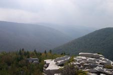
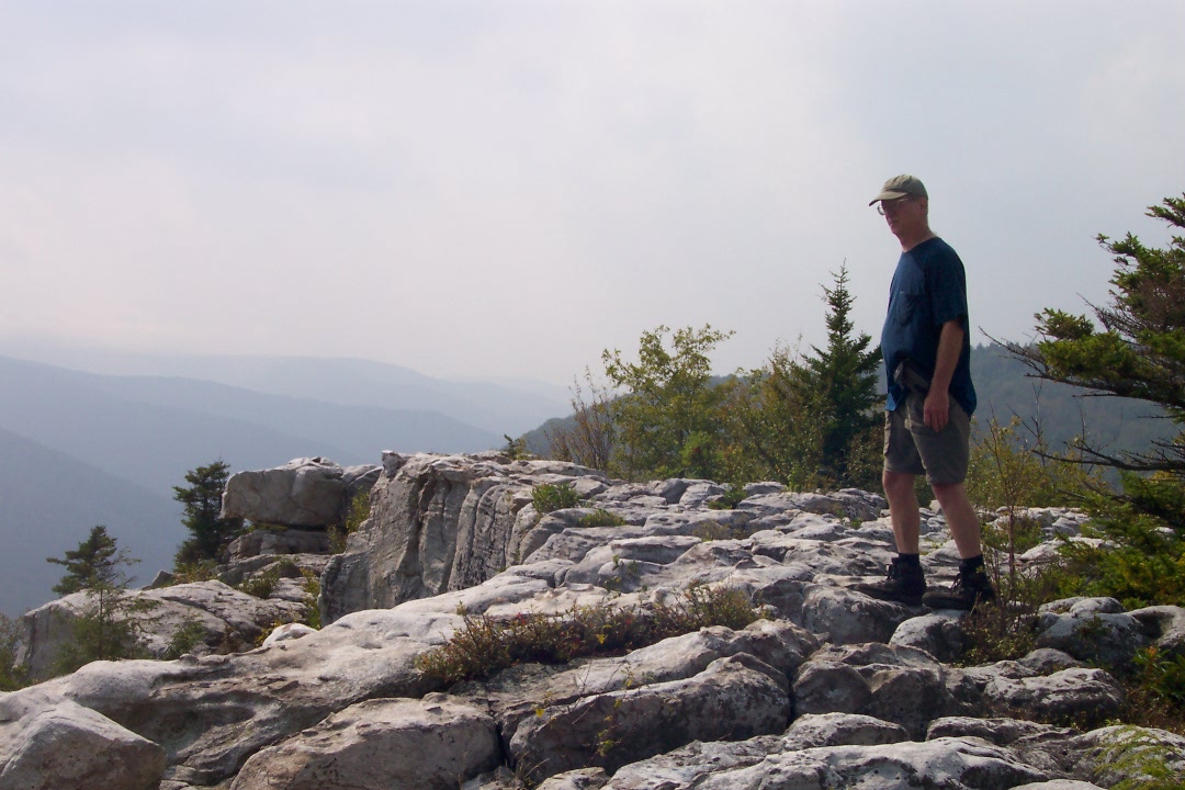
Pass several small Cairns on your right with hints of trails going up to the Lions Head. These are all difficult routes in comparison to the easier routes. Ignore them. For a bit you will find the path devoid of trees. At this point you are almost directly under the Lion�s Head. The trail will gradually turn north, paralleling the Big Stonecoal Drainage. As you begin to re-enter the woods watch for a cairn behind a log on the right marking a footpath. You may want to drop your packs here and bring your camera, water and snacks for the rest of this side trip. The trail weaves steeply, first through vegetation and then rocks. Cairns mark the way. Climb up through a fissure in the rocks to the top. Follow the Cairns on your left out to the edge to a grandstand view of the entire Red Creek Drainage. The Lion's head is to your right.
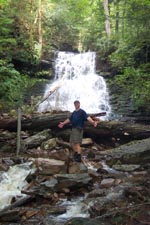
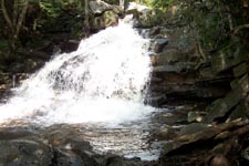
Return to Rocky Point Trail, recovering your gear along the way, and turn right. Rocky Point Trail ends at its juncture with Big Stone Coal Trail. Continue upward on Big Stone Coal Trail. Soon you will here a waterfall. It�s the one shown on this page. If you desire, drop your gear and bushwhack down for a great photo op. Note: the walls of the gorge are steep and slippery so take care!
Continue up Big Stone Coal Trail, descending to cross Stonecoal Run at about 0.5 miles from the previous trail junction. Travel a short distance up Big Stonecoal Trail to the intersection with Dunkenbarger Trail.
Turn left on Dunkenbarger Trail. In about 0.3 miles come to Dunkenbarger Run and a great campsite along the run . (I think there is a beer commercial about this place.) There is more camping on the other side and to the left, a short distance down stream. Cross Dunkenbarger Run and travel approximately 0.6 miles to the junction of Little Stonecoal Trail.
Turn left and descend rapidly along Little Stone Coal Trail as you get glimpses of the waterfalls to your right. Bushwhack to some of them at your own risk and enjoyment. The really big one that Fulya is standing in front of on the Sierra Club website is about 1/3 of the way down.
In
about 0.8 miles reach Red Creek. If the stream is fordable,
cross it and locate the
High water route from Little Stone Coal Run: Walk downstream from the ford. Sometimes you may be able to walk along the rocky bank. Cross what appears to be a stream. Actually it is a backwater of Red Creek. Shortly pass this point probe the brush for access to what appears to be an old overgrown road leading generally down stream. Eventually this will bear away from the creek and stop in a marshy area near a beaver dam that blocks the previously described backwater. If you look out beyond the backwater, over the beaver dam, you may spot an old forest road going up the side of the hill. This is the continuation of the road you are on. If you cannot easily make your way to it from the marshy area regain the creek bank as quickly as possible. Walk down the bank, searching the opposite shore for the confluence of that first backwater you crossed in the morning. When you find it turn your back on Red Creek and bushwhack in a northerly direction through some relatively open woods, crossing the backwater at a more manageable point and climbing steeply to gain the old forest road. Walk up the road keeping an eye out to the left for a well worn but narrow footpath. Follow it steeply down to the old steel bridge on Rt 45 which you drove acrossin route to the trailhead in the morning. Cross the bridge and walk back to your car. ________________________________________
________________________________________ Name: Person
Hike : Red Creek/Dunkenbarger Loop ________________________________________
Name: Ed S. Hike: Red Creek/Dunkenbarger Loop Date: 08/25/13 Rating: 4.5
Critique: This is a nice hike, especially with regards to water features. It's rather different than the meadows of Dolly Sods North. On the plus side are the waterfalls and cascades, plus some mountaintop views. On the minus is the lack of the expansive meadows to the north. I suppose the main issue I had with the hike (other than it taking longer than expected) was that many stretches seemed somewhat typical, and not too much different from other more nearby destinations. But that should not make one think that this is a bad hike. The waterfalls, and the views make this hike more than worthy. The different forest types, from dense pine and spruce stands, rhododendron lowlands, and mixed forests give it a wide variety as you move from trail to trail. The streams are different, from serene Dunkenbarger Run, roaring Big Stonecoal Creek, majestic Red Creek, and the cascading side runs of of Red Creek. Watch out for muddy trails, especially Dunkenbarger and parts of the Red Creek Trail.
________________________________________
Name: Bob Hike: Red Creek/Dunkenbarger Loop Date: 10/12/13 Rating: 5
Critique: There has been recent trail work on Red Creek. All blow downs that cross the trail have been cleared.
________________________________________
Name: Ben Hike: Red Creek/Dunkenbarger Loop Date: 05/25/13 Rating: 5
Critique: I did most of this loop as part of a longer backpack trip over memorial day. The trails were beautiful and the view from the Lion's Head was great. One word of warning. As of the date that I did the hike there are still a lot of blowdowns, probably from hurricane Sandy. They were particularly bad on the Dunkenbarger trail where sometimes every 50 feet there would be a another tree down. Since most of the forest on the Dunkenbarger trail was Pine and rhododendron it make getting through or around the blowdowns a little trickier than if it was an open hardwood forest. That being said I was able to get through but it took about twice as long as it normally would so just plan on taking extra time until these get cleared.
________________________________________
Name: Andrew Hike: Red Creek/Dunkenbarger Loop Date: 04/19-21/13 Rating: 2
Critique: Only rated so low because of the poor trail conditions. There was so much storm damage that I lost count of the downed trees after 100. The lower points of Red Creek were particularly undetectable - might as well just bushwack. The water level was also raging. We waded in waist deep, some opted to crawl over logs hands and knees. Once up on the plateau things got a little less hairy - snow must not have been as heavy up there. The nice group camp at Dunkenbarger and Big Stonecoal was still intact and beautiful as ever. ________________________________________
Name: mtc
Hike: Red Creek / Dunkenbarger Loop
________________________________________
Name: DAVID M.
WATTS
Hike: Red Creek/Dunkenbarger Loop
________________________________________
Name: WVwanderer Hike: Red Creek / Dunkenbarger Loop
Date: 06/16 to
18/06 Rating: 4 ________________________________________ |
|
|