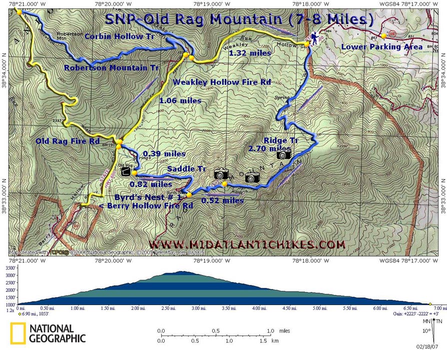
|
_______________________________________

_______________________________________
Name:
Eagle
Scout/Outdoorsman
Hike: Old Rag
04/26/14
Rating: 5
Critique: I do a lot
of Backpacking in the Shenandoah National Park (SNP). I've done Old
Rag about 7 times. I decided to do it this time as a Backpacking
trip instead of a hike. It was just as worth it, and the backpacks
made for an extra challenge while scrambling the rock faces. This
loop has gorgeous views, and excellent terrain. The rock scramble is
arguably one of the best in Virginia. Bring plenty of water (at
least 2 liters) and trail food. We got a late start (arrived at the
trail head at 9:45) and had exactly the right amount of time to make
it to a suitable area to camp along side the creek running by
Weakley Hollow fire road. For as long as I can remember, the parking
lot for this area fills up FAST. ESPECIALLY on weekends. I would
always recommend getting to the parking lot by no later than 8. This
hike can easily be done in 8-9 hours if you are in good shape. It's
one of the best hikes in the SNP in my opinion, and I honestly
cannot recommend it enough.
_______________________________________
Name: KCJones
Hike: Old Rag
05/17/14
Rating: 4
Critique: 4 Only
because the crowds...Screaming kids ...groups and a very full
parking lot...serves me right - nine on a
Saturday. However, the rock scrambles and the views are so so worth,
its like a giant play ground. I really enjoyed climbing scrambling
and squeezing though the rocks. I went alone was originally
concerned it was a bit to much for me... as I am athletic but not
super athletic...Little sore but finished in about 3 hours and 30-45
minutes (picture taking time included). The fire road was not as bad
as I thought it would be boring wise because I could hear and see
the water on the way down. I will be going again at some point but
as early as I can and on a week day. PS, its pretty well marked and
easy to follow due to its heavy use I went map-less and I was fine.
_______________________________________
Name: Ed S.
Hike: Old Rag
Date: 04/22/13
Rating: 5
Critique: I finally
made it down to Old Rag, having wanting to go there for probably
about 20 years now. It does not disappoint. From the open lot, the
hike is about 9-9.5 miles. The beginning is a long switchbacked
climb, sometimes near boulders, a couple of wet spots, some views of
what's to come. Then is the rock scramble. I've done Billy Goat,
Sunset Rocks, Potomac Heritage and other well known rock scramble
trails. They have nothing on old rag. Drop into crevices, shimmy up
another, jump and step over yet others. Take a short caving
expedition. Numerous views in all directions during this time. It
was a weekday, and so, while plenty of people were on the mountain,
I got to do the scramble fully by myself. There were plenty of
people at the summit, along with basically 360-degree views. The
return by the Saddle Trail is all downhill, with some views left,
one of a balanced rock on the southern part of Old Rag. Finally
comes the long fire road walk, the least interesting section of the
hike, but there were displays of white trillium along the way, plus
views of cascading Brokenback Run and the Hughes River, the last a
short side trip along the beginning of the Nicholson Hollow Trail.
_______________________________________
Name: Penny
Kennedy-Smith
Hike: Old Rag
Date: 10/14/12
Rating: 5
Critique: We are both in our mid 60's and had not climbed Old Rag
since living in Va in the early 90's. it was hard work but
absolutely fantastic and the sense of achievement when we got back
to the car was wonderful! It was very crowded and everyone was
(much!) younger than we were but people were so friendly and
encouraging over the more difficult bits. The scenery was every bit
as beautiful as we remembered and though I doubt we will climb it
again (due to living in England) it was by far the best climb we did
on our recent visit. It gave my husband's year old hip replacement a
good work out! Highly recommended!
_______________________________________
Name: Judith Hafner
Hike: Old Rag Mountain
Date: 6.4.2012
Rating: 5
Critique: I am 54 years old and this was my first hike of any level
challenge, other than a stroll in a local park or on flat ground. I
will admit it was a challenge for me but it was a suggestion from my
daughter as something we could do together. she attends and teaches
boot camps. So her having faith that I would do well was a very
great compliment. Though there were difficult spots the others on
the trail were very encouraging and helpful. She was patient with me
as I did have to stop many times to rest and drink. I do have
several health issues but she is a nurse and as said earlier she
thought I could do it. I did make the whole loop of the trail and
truly enjoyed the view from the summit. To feel like the birds and
experience the majesty that only God could create can only be
eclipsed by the birth of your own child. The views are fabulous and
beyond what is seen in the pictures we all share and take on this
hike. I have to say if my daughter did not suggest this trip for us
I would have missed out on an experience of a lifetime. I will be
forever in debt to my daughter for this outing.
_______________________________________
Name: Dave
Hike: Old Rag
Date: 4/7/2012
Rating: 5
Critique: This was my second time hiking Old Rag. My first was in
2009. This trail is fun, but it is difficult and not for everyone.
When we were walking past the trailhead after finishing the hike, we
saw so many people who were completely unprepared for the hike it
made us wonder how the ranger at the parking area could ethically
allow them to start the trail. Senior citizens wearing crocs, dads
with two year old kids on their shoulders, a little girl in glittery
shoes with a stuffed rabbit, etc. You can read the full description
of our hike on my
website.
_______________________________________
Name: kth-7
Hike: Old Rag
Date: 4/14/2012
Rating: 5
Critique: I don't have a lot of hikes to compare it to, except Bull
Run Mountain, which I would rate a 2.5. My sister and I did this
hike and loved it. We are the type of people who work out 3-4 days a
week, run a couple of races, and are usually active. We were pleased
with our ability to do the rock scramble and steep hike upward (at
times). We arrived at the parking lot at 6:30am. There were only a
dozen cars in a 200 car parking lot. Bring money. The fee is $15.
The climb up was just as interesting to look at as the climb down.
There was a lovely stream that flowed over huge boulders most of the
way down. Everyone should do this hike once in their life.
Just a note: if you want to do a part of this hike and not strain
yourself too much, just go up in reverse. Take the yellow blazed
Weakley Hollow Fire Road trail to the blue blazed Saddle trail and
up to the Old Rag shelter. Then come back down. This in itself is
about 4 miles.
_______________________________________
Name: Greg Romano
Hike: Old Rag Mountain / White Oak Canyon
Date: June 2008
Rating: 5
Critique: I took a group out and we backpacked Old Rag Mountain and
linked over to finish down the White Oak Canyon. This was a
fantastic hike! Old Rag is a classic and belongs in Cooperstown. It
is by far one of my favorite hikes. It is a strenuous climb but once
you near the top the bouldering is way too much fun. This is the
part that keeps me coming back and is a great place for the
adventurous type! We hiked on a clear and hot day and this did pose
some water problems for us. Make sure you bring plenty of it. We
then spent a day on some connector trails to get over to White Oak
Canyon. This was an unexpected surprise. I had not done much
homework on WOC, so to see the size of the waterfalls was a pleasant
surprise. The grade on WOC is steep and there are no switchbacks, so
be prepared for a climb.
I have been taking high schoolers out on backpacking trips for
several years, and this trip has been a favorite. I can't wait to go
back!
_______________________________________
Name: Greg S.
Hike: Old Rag
Date: 12/17/2011
Rating: 5
Critique: Background: My wife and I hiked this as one of our first
dates a few years ago, and it was memorable for the wrong reasons. I
wore the wrong socks and tore my heels open on the way down off the
mountain. By the fire road I had wrapped my heels with bandanas and
ended up limping the rest of the way back. We wanted to erase that
memory so we tackled this hike again a few days ago.
12/17: For a couple in their mid-20's, we found this hike to be
exactly what we were looking for. We moved quickly, and we were back
in our car exactly 4 hours after we started. We had time to stop on
the north summit, as well as the true summit, but other than that we
were hiking at a brisk pace. For December the weather was beautiful,
with clear skies and little wind.
Honestly, I can see how the rock scrambling could be difficult if
you're not in decent shape, so please be realistic with yourself
before you start this hike. If you're not much of a hiker and you
are just going for the great view from the top, you might need to
find a different hike. All in all however, this is a hike that
everyone should do at least once if they live in the DC Metro Area.
Totally worth it.
_______________________________________
Name: Rich Johnson
Hike: Old Rag
Date: 02/11/2011
Rating: 5
Critique: A friend and I set out to climb Old Rag. We set out from
the lower parking lot at 5:40AM. It was only 9 degrees. Going up
through the woods and the switch backs was pretty easy going. There
was a few inches of snow with a layer of ice beneath. We got up the
some of the first vistas just after sunrise and we had very clear
skies. Getting up to the actual summit was a little tough. Most
boulders were covered in ice and snow so climbing up and finding the
blue blaze route was a little tough. We managed to follow and make
our own route around the ice covered boulders. Awesome views from
the summit. Coming down the north side was very hard. I fell
countless times due to all of the ice. Finally I just did some
glissading. It was pretty fun. Once down the the fire it was easy
going. Awesome winter trip. Didn't see one other person from the
time we left the car till the time we got back.
_______________________________________
Name: Lydia
Hike: Old Rag
Date: 7/19/09
Rating: 5
Critique: My partner, Kate, and I went out and hiked Old Rag in the
morning to beat the crowds. The last time I was there, there was a
bus full of boy scouts and we went up the back way and missed part
of the scramble. I love this hike and think the upper body and mind
challenges it gives in addition to the leg workout, is awesome. My
heart is full and I'm waiting till I can walk without a cane again
to return.
_______________________________________
Name: Jos� Calvo
Hike: Old Rag
Date: 7/6/09
Rating: 4
Old rag is an
old favorite and I recently re-did the hike - it did not disappoint.
I would highly recommend getting there early OR LATE to avoid the
crunch in the upper parking lot. That might be the one downside -
the hike is so popular that you're unlikely to have your own space
or silence for long. The plus is lots of friendly faces or
commiseration if you're into that sort of thing.
Old rag remains unique for combining a difficult hike with some very
unusual rock formations that require scrabbling and even upper body
strength to lob your limbs up cracks and across a sheer cliff-like
face here and there. I would not do this hike alone unless you are
able to lift your body weight on your hands & arms (think push ups
or better yet "dips)." The rocks make this a really fun hike.
In the summer most of this hike is in the shade, but of course the
top 1/4 mile or so will expose you to a lot of sun.
Great views along the way so if you need an excuse to stop and pant,
you'll get them.
Biggest downside might be how long that fire road seems at the end.
It's easy to do, but by the time you get to it realizing you have
over 2 miles to go, and go, and go is just painfully dull.
J
PS thank you for
the fantastic web site - I've been neglecting hiking for many
months, but your site (still bookmarked in my browser) makes it
really easy to scope out the old haunts.
_______________________________________
Name: Jos� Calvo
Hike: Old Rag
Date: 7/6/09
Rating: 4
Critique: Hey! Hey!! HEY!!! This isn't really a critique so much as
an alert - your driving directions are wrong! The google maps link
works fine, but if you follow the route it sends you on you cannot
get to old rag at all. In fact, it's been wrong so long that some
VERY NICE PERSON put up their own homemade wooden sign at the turn
that says "Google maps is wrong!" and gives directions that will get
you to old rag.
So - yes loved the hike as everyone does, done it many times, but
please update your site to give directions NOT GOOGLE MAPS :)
Thank you!
MRHyker Note: More detailed
directions are in the Trail Notes. A suggestion to use them are now
noted after the Google Map Directions.
_______________________________________
Name: Rob
Hike: Old Rag Mountain
Date: 6-21-09
Rating: 5
Critique: I have lived in Wyoming, Colorado, and Idaho. While this
may not have the solitude of a hike into the southern entrance of
Yellowstone Park, it was one of the best hikes I ever had east of
the Mississippi.
I went by myself and got there at 1pm on a Sunday. This was a
perfect time and I was able to park in the upper lot.
The trail up to the scramble is a consistent incline and very easy.
The rock scramble was awesome and much more impressive in person
than described anywhere I have read.
However, I was not able to complete the circuit and I got rock
jammed at the minor summit. I spent 20 minutes trying to figure out
how to get through a crevice/fissure that was narrow, tight, and
slick on the sides. I tried over and over to put my back against one
side and use my feet to push up against the other side to no avail.
I was so pissed as I wanted to get to the top badly. I did not run
into anyone while struggling so I am not sure if I was lost or what
though the blue blazes were all over the walls of this thing. So I
turned around and went back.
Despite not summiting, I still enjoyed the trek!
_______________________________________
Name: Travis
Hike: Old Rag
Date: ?
Rating: 5
Critique: I have hiked this mountain over a dozen times starting
from when I was just a kid. I absolutely love it and never get tired
of it. There is always something to see when you're: there, bear,
deer, and of course the scenic overlooks. If you're into landscape
photography like I am I highly recommend a fall/winter hike. You can
get some really great shots during the winter season even though the
hike is a little more treacherous due to snow and ice.
All in All a must hike for any outdoor enthusiast.
_______________________________________
Name: Mark Raven
Hike: Old Rag
Date: 10/24/08
Rating: 5
Critique: Not that Old Rag needs another critique,
but this is a terrific day hike. We went on a windy, chilly Friday
afternoon and encountered barely a handful of people during the
hike. The views on the way up were fantastic, but we had no views
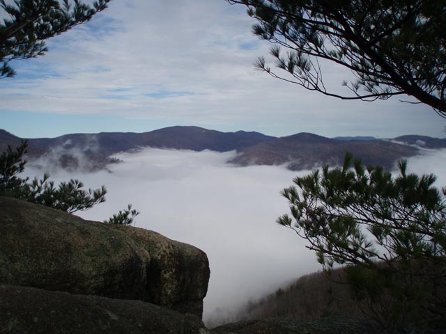
from the summit due to the clouds that had descended on the
mountain, but it was really cool nonetheless. The rock scramble
wasn't easy, but wasn't incredibly tough either. The loop as
described on this site took us about 4.5 hours, and we took hundreds
of pictures along the way. Tremendous hike, highly recommended.
_______________________________________
Name: Faye
Hike: Old Rag
Date: 7-29-2008
Rating: 5
Critique: Loved this hike...but very strenuous. I would not advise
for a person out of shape. The rock scramble was a great challenge.
There are some nice shady areas to enjoy your lunch. A lot of
different areas to look out over. Once you get to the summit its all
worth it. It was very breathtaking.
On our way down it was nice to stop at the two shelters to take a
breather. It does seem to take a while to get back to the parking
lot... It was the easier way to go but a little longer.
We did see one bear cub on the side of the fire road. So so cute. We
were sure the mother was close so we kept a steady pace.
I'm happy to say I hiked the Old Rag.
_______________________________________
Name: Andrew
Hike: Old Rag
Date: 12/31/2005
Rating: 5
Critique: Came up here with my wife and brother, camped up at the
camp line making the loop backwards. Then hiked up to the top to
drink a bottle of champagne at midnight on NYE. It was clear and
beautiful up there at night. The wind was blowing like crazy.
_______________________________________
Name: Josh Vaugh
Hike: Old Rag
Date: 11/23/07
Rating: 5
Critique: I live in Luray. My brother and I ran this with a kid from
his school, and it was really fun. We ran most of the way to the
top, walked the top, and then ran most of the descent. From the
lower parking lot and back, we completed it in 3 hours, .5 of which
were sightseeing. Not the best trail for running though.
_______________________________________
Name: Jeff
Hike: Old Rag
Date: 10/07/2007
Rating: 5
Critique: Very challenging but beautiful hike. For those that do it
with kids like we did please be careful as you do the rock scramble.
My 8 yr old son began to gain some confidence/excitement as we
climbed but I felt more comfortable leading as we got closer to the
summit. Great hike.
_______________________________________
Name: Kelly
Hike: Old Rag
Date: 9/14/07
Rating: 4
Critique: My first visit to Old Rag and I enjoyed the hike. I was
there on a Friday morning early to be ahead of the any crowd and was
able to park in the small parking lot closest to the trail head. The
hike to the rock scramble has a few picture opportunities. The rock
scramble area was a great experience very different from my other
hiking experiences as you pull your way up and boulder hop in a few
places. After reaching the summit the decent was uneventful on the
fire/service road until I spotted three bear cubs and bit further
came upon a ten point buck that was no more than fifteen yards off
the trail.
I will return again during the week.
_______________________________________
Name: brad
Hike: Old Rag Mountain
Date:09/01/07
Rating: 5
Critique: an astounding hike. I agree with my sister though, I
really just like the rock climbing.
_______________________________________
Name: Brad
Nicholson
Hike: Old Rag
Date: 28 July, 2007
Rating: 4
Critique: Having heard so much about this trail I decided to see
what all the buzz was about. The trail was a good hike with
wonderful views. However, obvious heavy use keeps the trail beaten
down and very wide. It was also very crowded but then again I was
there on a Saturday. At times it was easy to feel like a just
another coolie shucking a load for some Sahib. All that aside it was
a fun trail, the 3d class scrambling along the ridgeline at the top
was fun. Lunch in the shade of the rocks was perfect as well. I
think the best thing to do is go during the week or in the
off-season. Will be back in the fall and winter.
_______________________________________
Name: Joe
Hike:
Old Rag
Date: 4-6-07
Rating: 5
Critique: Amazing. Myself (an avid hiker) and a friend, who is a
surveyor for the state of West VA (i.e., he gets paid to hike the
state), were both amazed. Wow. We had stayed away because of the
crowds-what a mistake. A couple of quick notes-it seems that if you
arrive early (ie. sun-up) the crowds are non-existent. Secondly,
the upper body strength issue CAN be overcome with numbers (We
witnessed folks of all abilities making it up just fine.). The
height issue cannot-there are some places where it feels as if you
are atop a 3000ft cliff. All in all, it was simply an excellent
hike.
_______________________________________
Name: ElliottsKnob
Hike:
Old Rag Mountain
Date: September 23, 2006
Rating: 5
Critique: Old Rag Mountain is certainly on my list of "must hike"
trails. Every year I help lead our Church Youth on this challenging
adventure and we've been going since 1997. Throw in my own trips
[solo and with my own children] and... let's just say I can bring
some of the climbs clearly to mind as I sit here.
We had ten junior high and high schoolers and five adults. Heading
out early Saturday morning to beat the crowds from Washington, we
saw quite a few families with young children. The parents seemed to
be of the active, in shape persuasion and these families were having
a wonderful outing. A few adults who were out of shape and had been
coerced to go were huffing along but clearly were making it.
A couple of miles in you start working the rock. It is fun working
through crevasses and through a landscape of boulders that reminds
you of scenes from Lord of the Rings. I don't think I'd have been
too surprised if Elijah Wood and his band of Hobbits had met us in
one of the crevasses. You think you've made the summit only to
discover there's more climbing and scrambling.
The summit is a unique place and the huge granite boulders lend an
air of adventure to our lunch break. All too soon its time to head
down the Saddle Trail. The rocks are wet in places and my Vasque
boots slip out as I walk down a relatively flat part of the trail.
Turns out I'm the only injury we have this trip.
When we reach the trailhead parking area, a yearling Black Bear
wandered across the road. We got a great look and the kids loved it!
It's a great hike!
_______________________________________
Name: Scott
Hike:
Old Rag Mountain
Date:
3/10/01-Present
Ranking: 5 (Perfect)
comment: Old Rag was the first hike that
I had ever done. That being said, I had heard that it was a
challenging hike, but on that particular day, it was more
challenging than any of us thought it would be. Though it was about
50 degrees at the base of the mountain, the last third of the hike
toward the summit was all snow and ice. This makes the rock
scrambles a whole heck of a lot harder.
Long story short, I have
been hiking all over Georgia, North Carolina, South Carolina,
Maryland, and Virginia, and Old Rag is still by far my favorite day
hike, and I still try to get there once a month, regardless of
season.
_______________________________________
Name: Jean-Louis
Hike name:
Old Rag Mountain
Date: 7/2/05
Ranking: 4
comment: This hike is hyped way too much for
what it is. The boulders, a small part of the hike, are the main
attraction but they are smeared by the mark of hands and shoes
making it difficult to find peaceful solitude, even if you beat
the crowds. The rock trail provides a varied obstacle course
requiring hands in a few places and good balance. This in itself
is worth the hike. The trail and summit area are trash-free
despite the traffic and the views from the top are nice,
particularly when the morning humidity is rising in the valley.
The circuit took me 2:45hr starting at 7am and I was back in DC
for lunch.
_______________________________________
Name: Dawn
Hike: Old Rag Mountain
Date:
9-9-05 Ranking:
5
Critique: This is an awesome trail!! I have hiked this one
well over a dozen times, and only once did I not have a full
backpack. Upper body and arm stregnth were never an issue (as I have
little), and I rarely needed to remove my pack. The boulder field is
wonderful and unique. I've enjoyed a few beautiful sunsets from the
summit and hiking back down the boulder field in the dark is a
completely different experience. It has been a while since I have
been there, but I hope to get back again soon!
_______________________________________
Name: Greg
Hike:
Old Rag
Date: 9, 18, 2006
Rating: 5
Critique: A very challenging hike, as the
boulder scramble requires some low end climbing skills. I met 4 women on
the trail who were at what I would estimate was the half way mark (in
terms of the boulder scramble). It had taken them 4 hours to reach that
point and they looked tired. I think the lesson from that is be
prepared in terms of time and food/water.
_______________________________________ |