|
Otter Creek Backpack |
|
|
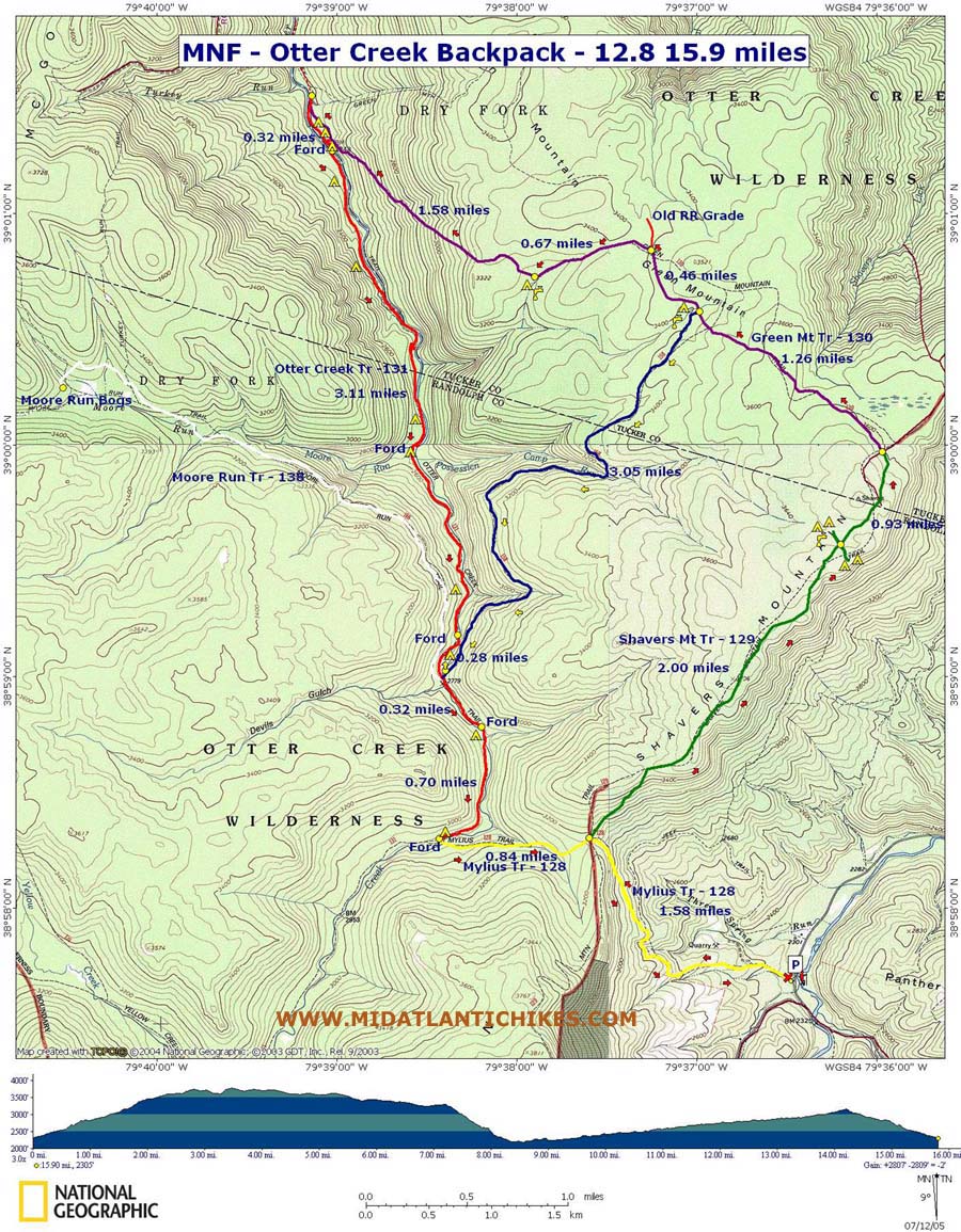
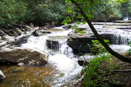
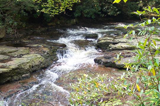
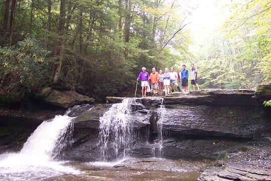
Description: This can be either a 12.8 or15.9 mile moderate backpacking trip (Base Mileage) through one of the prettiest wilderness areas in WV. Side out and back slackpacking hikes can be spun off of these loops. The hardest part is accomplished at the very beginning: hauling your packs up a 1300 foot elevation gain over 2.5 �3.0 miles. Once on the top of Shaver�s Mountain you will walk along a relatively flat ridge trail, weaving in and out of mixed hardwoods and conifer plantations. You�ll then descend via Green Mountain and Possession Camp Trails to Otter Creek, the focal point of any hike in the area. Here you�ll be able to explore the many falls, chutes and rapids along a 4 mile stretch of the creek, some without the encumbrance of your pack or explore the bogs of Moore Run on McGowan Mt., before climbing up and over Mylius Gap as you return to your cars. The route described here is the shorter route and uses Possession Camp Trail to descend into the valley. Use the Green Mountain Trail to the creek for the longer route. Tent icons mark some of the better campsites. |
|
GPS data is for this long route. Most of Possession Camp Trail is a railroad grade and pretty obvious. Being a wilderness area, there are no signs or blazes in the Otter Creek area. The trails are, however, well worn and the intersections, for the most part, are marked with cairns. Bring an accurate map and trail description when undertaking any outing here.
Directions from US33 at
Alpena Gap:
________________________________________ |
Zipped National Geographic. TOPO! GPS and Universal GPX Files |
Trail Notes: Mylius Trail (TR128) starts as an old gravel jeep trail. As the grade increases a grassy jeep trail bears to the right. Continue straight on the well-worn road. You�ll cross a power line swath and a wildlife clearing (I don�t recall the order.). Soon the grade will increase even more as it passes an abandoned pasture full of Hay Scented Fern enclosed in barbed wire on the left. At this point bare right onto an obvious narrow footpath that climbs Shaver�s Mountain at an angle. For a short distance near the top you�ll find yourself back on a pretty flat jeep trail before the final ascent to the top of Mylius Gap on another narrow footpath.
The intersection with Shaver�s Mountain Trail (TR129) at about 1.6 miles from the beginning of the hike is at a flat area under a canopy of large trees with little under story. All four directions are marked with cairns. You�ve climbed 900 feet so far. Turn right onto Shaver�s Mountain Trail and climb another 400 feet over the next mile or so. Only the beginning of this ascent is steep. The rest is pretty gradual.
At about 2.00 miles from the last trail junction come to an apparent four-way intersection. A left turn will shortly lead you to a grassy area and spring. A right turn will lead to the site of an old shelter which has been removed. Both are good places to camp should the need arise.
Continue on for another 0.93 miles (Includes side trips to spring and old shelter site so is actually less) to the junction with Green Mountain Trail (TR130). There used to be a sign hanging from above on Shaver�s Mt Trail noting �Trail Abandoned� for the continuation of that trail. I think the trail has been rerouted away from that junction and it now, more or less, merges into Green Mountain Tr. There is no sign. Bear left (North-west) and follow Green mountain Trail to the junction with Possession Camp Trail (TR158) in a Grassy area surrounded by conifers. This is another good mountain top campsite if the small stream that crosses Possession Camp Trail close by has water.
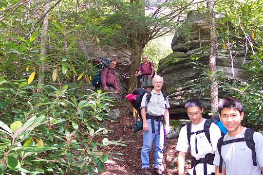
SHORT ROUTE: Possession Camp Trail is one of the most picturesque mountainside trails in the valley. Almost it�s entire length is along a railroad grade encapsulated either with Spruce and Hemlock or mature deciduous trees. At one point you�ll descend between some large rocks and quickly regain the railroad grade. |
|
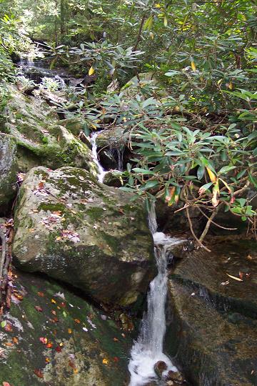
In about 1.2 miles from the last turnoff cross the headwaters of Possession Camp Run. As you reach the opposite bank look for a collection of lumbering artifacts that previous hikers have deposited on a large flat rock on the left side of the trail. In another 0.5 miles the trail will become exposed more to the sun and is the probable cause of a healthy growth of Green Brier in this area. This soon dissipates as a mature forest once again surrounds the trail. In another mile cross an un-named tributary with a nice set of mini-cascades and descend to Otter Creek (3 miles from the last trail intersection.
The intersection of Possession Camp Tr with Otter Creek (TR131) and Moore�s Run Trails (TR138 - on the other side of Otter Creek) occurs at a large rock. The intersection itself is marked with a cairn. Turn right and in about 0.2 miles reach a huge campsite. This is the first option for camping. There are other sites all along Otter Creek in either direction between Green Mountain Trail to the north and the Creek crossing south of Possession Camp Trail. When I lead this particular circuit we camped here and visited the many falls and slides between it and the next southern creek crossing on day one. On day two we left our gear and visited Moore�s Run (1.2 miles north of camp after crossing Otter Creek) and the falls in between before finishing our trip.
LONG ROUTE: From the junction of Possession Camp Tr and Green Mt Tr turn right (West) staying on Green Mt Tr. Initially you will be hiking on an old RR grade. In about 0.46 miles look for a cairn and footpath to the left off of the grade. Turn left here and follow the footpath for 1.58 miles to otter Creek. (You�ll pass one more campsite w/water at 0.67 miles after leaving the RR grade. This is the last campsite before the creek.) Turn left onto Otter Creek Tr. There are 3 campsites here. The middle one is hidden up on a hill and is not used much. The last is right at the creek crossing.
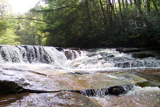
Proceed south on Otter Creek Tr. Fords are marked on the map. You�ll pass numerous waterfalls, rapids, chutes and swimming holes along the way. There is a short section a little after the first crossing where the trail leaves the RR grade and becomes a narrow footpath clinging to the side of a hill. There are a couple of bad blowdowns across the trail that can be tricky to climb over. Take your time and be careful!!! Make sure you visit the confluence of Moore Run with the creek. It�s the best break/lunch spot on the creek! At 3.1 miles from the last major crossing of Otter Creek cross one more time and arrive at a huge campsite along the creek. This also used to be a site of a shelter that was removed in keeping with wilderness regs.
If you get a chance visit Moore Run Bogs. Continue south on Otter Creek Trail for a few hundred yard to a cairn on the right just before Possession Camp Tr on the left (Big Rock). Cross the creek, climb a short hill to gain a RR grade and follow the trail for about 3.1 miles. (The trail continues further to the junction of McGowan Mt. Tr.) You�ll be able to see the bog to the left. Look for a faint trail covered with a few limbs to the left. Bushwhack at an oblique angle to the trail until you run into a Rhododendron thicket. Pick your way through this to eventually reach the bog.
CONTINUATION OF BOTH ROUTES: From camp head south (upstream) on Otter Creek Trail, passing Moore Run Tr on the right and Possession Camp Trail on the left.
Ford
Otter Creek at about 0.3 miles above Possession Camp Trail. In about
0.7 miles reach Mylius Trail marked by cairns. Turn left onto Mylius
and ford Otter Creek for the last time.
Climb steeply up Mylius trail for about 0.84 miles until you reach the gap and junction with Shaver�s Mountain Trail that you visited on the first day. Descend on Mylius Trail, retracing your initial steps back to your cars.
The origin of the el fresco industrial artifact museum: On the links (Otter Creek-SW and Otter Creek BP) that describe trips to the Otter Creek Wilderness area we make mention of this museum. We often pondered who started this on the bank of Possession Camp Run at the ford of the trail by the same name. Here�s the story: Hello MrHyker,
Printable/Downloadable Directions and Trail Notes _______________________________________
______________________________________
Name: Donna
______________________________________
Name: Steve Hike: Otter Creek Backpack Date: 04/14/15 Rating: 4
Critique: Awesome hike. The first two miles on Mylius are "straight up" (as told to us by a local that built the trail in 1969) and a good test to determine if your pack weighs too much. The Possession Camp Trail has several large fallen trees that will slow you down as you look for routes that will allow you to pass. In one case the only path was to climb the log and jump down. Crossing Otter Creek at Mylius can be a bit technical if it's rained recently. It was a gorgeous visit and I look forward to seeing more of the Otter Creek Wilderness. Thanks for the report.
______________________________________
Name: Wooly Bully, Shortstack, Christopher Robins Hike: Otter Creek Backpack (modified) Date(s): 08/16-18/14 Rating: 4
Critique: Having a base camp in mind we changed this hike to proceed
directly to the waterfall area. We originally planned to camp at the
Otter Creek / Moore Run / Possession Camp Trail junction, but ended up
proceeding further north to find an open site. Busy day, lots of
campers. But easy to why so many come here, the falls and deep pools of
Otter Creek make for great swimming in about as scenic a place as can
be. At this point we decided to ditch the base camp and proceed with a
regular backpack. We stopped at a really nice site, where Moore Run
joins Otter Creek. We spend most of our time hanging out on the large
flat rock, real nice views upstream, downstream, and to the side with
Moore run flowing toward us. Pretty cool having dinner practically in
the middle of the creek! Chris made a great campfire, and we hung out
real late to
9:30 or so. ______________________________________
Name: Kyle Hike: Otter Creek Backpack Date: 10/19/13 Rating: 5
Critique: Did the whole backpack loop. It was excellent. The trail damage has been cleared and is good to go. Only a few trees to duck under no big deal. The trail was great the descent on green mountain trail is steep and rocky a little rough on the knees but not to bad. Didnt see one person the whole trip!
______________________________________
Name: Michael Mac Hike: Otter Creek - Condon Run to Dry Fork Date: 06/17/13 Rating: 5
Critique: Hiked the entire length of the Otter Creek trail and, as noted already by Corey, there is approximately a mile and a half stretch near the middle of the trail that has yet to be cleared from the storms last year. Encountered only 4 people the entire hike: a couple hunkered down right in the middle of the aforementioned storm carnage, and 2 forest workers on their way to check out a significant landslide (on the Otter Creek trail, in the midst of the uncleared area). The workers informed me that this stretch of the Otter Creek trail, along with Green Mountain trail & Possession Camp trail are the only areas that remain to be cleared...and will be tackled in the fall most likely. ______________________________________
Name: Corey W. Hike: Otter Creek Backpack Date(s): 06/14-16/13 Rating: 2
Critique: **WARNING** *SECTIONS OF OTTER CREEK TRAIL NEARLY IMPASSABLE SUE TO FALLEN TREES AND LANDSLIDES* Our group of six began at Mylius trail head at 5pm. We climbed the moderately steep but charming Mylius and Shavers Mountain trails until we arrived at a nice flat grassy campsite near the edge of a cliff on Shavers Mountain where we found a mostly obscured view of the valleys and mountains in the distance. In the morning we filled up our water bottles at the spring at the campsite on the other side of the trail opposite our own, and continued on to Green Mountain trail. This trail was thick with vegetation, wet, rocky and steep as it neared Otter Creek. Some time after the first crossing we were forced to struggle through OVER A MILE OF FALLEN TREES, BUSHES, AND SOIL DANGEROUSLY CLOSE TO THE CREEK BANK which delayed us for several hours. Luckily we brought a small axe and WERE FORCED TO CHOP OUR WAY THROUGH SEVERAL FALLEN TREES TO GET THROUGH. We went on at a extremely slow and tiresome pace until nearly dark when we camped in a site surrounded by fallen trees. We were very worried we were not going to be able to make it out the following day, or if we would miss our turn altogether due to the fallen trees, and that we may have to go about 10 miles back the way we came. Thankfully, we found the next morning that we only had to travel about a quarter of a mile more through the fallen trees before we reached where the trail had been cut clear. From that point on the hike was pleasant and beautiful, but we were all so stressed over the hard trek over the destroyed trail that we didn't get to enjoy it very much and were just happy to have gotten out without more than cuts, bruises and fatigue. This hike would have been very enjoyable (5 out of 5 rating) if the trail had been clear, but as there was no warning of this danger at the trail head, I am writing this review to alert others of the adverse conditions to be expected. I for one would love to hike Otter Creek again, but not until the trail is cleared. Hike at your own risk and take care!
______________________________________
Name: Chris Hughes
Hike: Otter Creek Backpack - Lost Green Croc ______________________________________
Name: Androo
Hike: Otter Creek Backpack ______________________________________
Name: Steve Appler
Hike: Otter Creek Backpack ______________________________________
Name: Keith Lehman
Hike: Otter Creek Backpack The hike up from the Mylius trailhead was along a very well maintained forest road for about a quarter of a mile then turned onto single track. Shortly after crossing a clearing you go onto unmarked trail. At this time of year (mid-October) a lot of leaves are down and staying on the trail is challenging. My rule of thumb is if I walk about 200 feet and it doesn't look like a trail again, I backtracked. The right turn after hiking along the old busted up barbed-wire fence was where I had the most difficulty. Dont follow the old logging road, instead go a bit higher and look over a very large blow down to find the thinner trail going along the edge of the mountain. Further on there is another point of confusion where the trail splits off of another logging road. Look for a small cairn on the left. After the intersection with Shavers Mountain Trail its pretty easy going. I camped the first night at the ford about 7/10 mile north from the ford at the Mylius/Otter Creek intersection. There were several great sites at that intersection including one hard to find on a little side trail on the right off of Otter Creek Trail. Look hard for it as it appeared to be excellent (occupied when I got there). The next day we (me + dog) traveled north on Possession Camp Trail. The gentle railroad grade was super easy and there were several well-spaced water sources. The campsite at the intersection with Green Mountain Trail was not a good one. Its right along both trails in the open. There is a small site or two along Green Mountain Trail but they are rocky and of very low quality (no place to sit). The hike down the mountain is rather challenging due to a fair number of loose rocks and some pretty steep sections. It would be less fun coming up though I think. I camped the second night near the intersection of Green Mountain and Otter Creek Trails. The site was up over a hump on the left of the trail (not right on the water) and was pretty decent. There are better sites further down (or up actually) Otter Creek. Several great waterfalls and cascades will slow you down if you like scenery and picture-taking. Some of the water crossings were pretty challenging and you should take the time to switch shoes if you don't like wet boots. There were several manageable blowdowns but one small landslide took the trail away fro about 40 feet. When you get to this section backtrack a little bit and get down on the creek bed to bypass this section. The footing is very loose and dangerous (don't ask how I know this). The campsites near where Moore Run dumps into Otter Creek (not the trail intersection) look very nice and look to be near some good swimming opportunities (not tested). Overall, I can't recommend this area more highly. The scenery is very much like the lower half of Dolly Sods and there were far fewer people using the trails. I saw very little litter even though the trails seem pretty well used. I had a great time and plan to return regularly to explore more of the Otter Creek trail system. ______________________________________
Name: GaliWalker
Hike: Otter Creek Backpack (Day hike) ______________________________________
Name: Jim Leo
Hike: Otter Creek Backpack ______________________________________
Name: Ramesh
Hike:
Otter Creek Backpack ______________________________________
ame: WVwanderer
Hike:
Otter Creek Backpack ______________________________________ Name: Melissa Hike: Otter Creek BackpackDate: May 27-28 - 06 Rating: 4 Critique: Great info! We just got back from the same hike- although we hiked it in reverse order. I wish I had read this site before going. We spent quite a bit of time looking for the turn off to Shaver's Mountain Trail (from Green Mtn. Trail) only to realize we were already on Shaver's. Adding to our confusion was the "missing" Adirondack shelter. If you go on this hike, make sure to bring at least a good topo and compass.
______________________________________ Name: Michael P.
Bishton Hike: Otter Creek Backpack
Date: Sep 8,
2005 Ranking: 4
Critique: Thanks for the thoughtful effort you put into the information on your web site and to the service you provide the hiking/backpacking community in this area. The information on your web site really helped a lot in making this trip possible so that we would not get lost along the way and could enjoy the sights that Otter Creek had to offer. We plan to go back. We really enjoyed the varying landscape and microclimates that were a constant and changing feast for the eyes as we hiked along. From fern-covered areas under tall shading trees, through deep woods with fallen moss-encrusted trees and rocks, lovely meadows and the delightful walk along the creek. We camped on the edge of one of the meadows and watched the stars come out and fill in the arc that formed the Milky Way. We started late from the Mylius parking lot and hiked in a counter-clockwise direction, so we did not camp at the Otter Creek camp site that you show at the northern-most point on your map. We camped on the edge of a lovely circular clearing that exists at the intersection of the dark blue trail (on your topo map) and Green Mountain Trail. Your waypoints that shows camping/water sites came in really handy! I printed out your GPS text file and put your waypoints into my little GPS, which helped a lot because I knew when we were approaching the waypoints. My GPS agreed exactly with your waypoint locations but not with the total trip miles. Mine showed 14.9 miles with my tracking set on highest. I thought that was interesting. I printed out your hike description, which helped a lot as we went along so that we would know what to look for as we reached the important waypoints. I was able to help three backpackers along the way because of the information that we had taken with us from your web site (topo map, description and GPS log). Two of the backpackers took note of your web site - midatlantichikers.com - and planned to visit it for future hikes in this general area. ______________________________________
Name: Steve
Kelley Hike: Otter Creek Backpack
Date: Sept 17-18,
2005 Ranking: 4
Critique: If you want to experience a moderate, yet wild backpack, this is a good choice. While the hike up Shavers Mt. is nice, there are no views other than looking up under the tree canopy; the rewards are subtle, but the solitude is sublime. However, the star of this show is Otter Creek. At the north end of the trail, boulders the size of shotgun shacks litter the creek like play things. In the middle section of the trail, the water cascades off platters of stone. It is very hard to stray away from the creek once you reach it. One of my questions heading out was how long it would take to reach the trailhead. From Loudoun, we were able to arrive at the Mylius trailhead off CO 12 in 3:30, not including a 30 minute stop at Seneca Rocks en route. It's about 40 minutes from Seneca Rocks, crossing over the Eastern Continental divide We followed the directions for the loop up Shavers Mt. trail. The transition in the vegetation was quite interesting the further we advanced up the ridge. When we reached the rhododendron thickets, we thought "how interesting." Little did we know that they would become omnipresent for the remainder of the hike and give us a healthy appreciation for avoiding at all costs. The transition from the Shavers Mt. to the Green Mt. trail is gradual and not at all obvious as mentioned. Not traveling with a GPS, we relied on the description along with our map printout and a compass. The rest was dead reckoning, and with obstructed views of the surrounding landforms, this was, at times, a crapshoot. But we pressed on. By the time we reached the intersection with the Possession Camp trail, it was about 3 PM and we had been hiking steadily for 3 hours. We decided to set our sights on reaching the north end of Otter Creek continuing on Green Mt. trail. However, we ended up following several single-track paths through fern covered terrain, but the paths seemed a bit inconclusive - not quite sure of the railroad grade mentioned which we thought would be fairly obvious. We backtracked toward the cairns, then warily entered a trail that seemed to have what looked like a railroad grade berm on either side. I say warily because the rhododendron crowded in on the path, reducing it to a mere 12" of space at shoulder height. We gamely advanced through the thicket as the branches beat on our packs like a car wash. To say we weren't too certain this was the path would be an understatement. But the berm that ran parallel to our route indicated it was some residual railroad grade. Eventually, it opened up and we made it out of the thicket, but the thought of perhaps being wrong of the path was a source of some consternation, but the compass indicated we were headed in the right direction. The remainder of the trail followed the script all the way to the final toe jam section down to Otter Creek. We made it there by 4:30. We turned south at that point and set up camp about 150 yards north of the intersection. The campsite was very nice and offered privacy. Not having time to explore extensively, we set up camp and prepared to rest. The creek was pretty cold, but I managed to ice down my feet and legs in a shallow pool - it was very peaceful. The next morning, we dawdled a bit and didn't break camp until almost 10:00. Looking at the map, we thought the ford was at the far northern tip to where the trail is colored red. We headed right (north, or downstream) from our campsite, past the Green Mt. trail intersection, until we figured we could ford the creek. We crossed the creek, but on the other side there was no obvious trail. How could it be? We crossed back. Then went further south (up stream) and tried again. On the other side, the ubiquitous rhododendron embraced us like tourists on the wrong side of town. This was getting weird, we thought. We crossed back again. Finally, we walked back to our campsite - there had to be a trail across the creek! We crossed - no trail. We crossed back, but then I spied cairns upstream about 50 yards. The ford was marked with a tall cairn of rocks on either side. Chagrined, we went up stream, took off our boots and waded to the west bank. Nearly 2 hours after setting off we finally crossed the damn creek about 200 yards upstream (south) of our campsite. We had basically had camped on the Otter Creek trail without realizing it. We then had to hike double time to get back on schedule. We made it over/around blowdowns and muddy corduroy paths as the trail hovered over Otter Creek and finally took in some very picturesque waterfalls. A lost hunting dog adopted us along the way and we had lunch at the Moore Run falls. Around the time that we forded back to the to the east shore (this should be marked "Ford #2" if heading south) of Otter Creek at just south of the Possession Camp trail intersection, we ran into a group that was a little confused by the trail. We estimated we were near Possession Camp, but were pretty much opposite Devils Gulch. However, after leaving them behind, we crossed at a ford to the West Bank (ford #3 southbound) then ended up continuing upstream (south) some more. We ended up missing the cairn marking the Mylius Trail ford (#4 crossing from northwest to southest). We overshot it by almost a mile and had to retreat. We ran into the same group - also using your description. For some reason, they were just as confused by the Possession Camp/Otter Creek intersection as we were. The compass told us we were going west-southwest and we knew we had missed a turn. We went back to the cairn and crossed the creek. We found the Mylius trail up a steep embankment as described. The rest of the trail was a sprint back up the Mylius Gap and back to the car. We had made it out of the Otter Creek Wilderness Area. It was not easy, but we wanted a challenge. But the challenge was in interpreting the directions - perhaps more detail on the fords (cross to the east or west bank). I believe that we were thrown off by the ford (second from the north on your map) that we did not have to cross. A picture and reference to the Moore's Run falls would allow for one distinct landmark (it is listed simply as a ford on your map) Closer scrutiny of the directions revealed where we got off track, but the Mylius / Otter Creek intersection was obvious (traveled southwest more that 10 minutes!) once we realized our mistake. Without a GPS, compasses are an absolute must, but don't expect to make out landforms other than the creek - every ridge looks nearly identical to the uninitiated! While it would be nice to follow the Adirondack's definition of wilderness areas and, at minimum, identify trailhead markers, you get none of that help here. The water was low enough to allow us to "dry ford" all but the northernmost ford. While the water was cold, I can see how it would captivate kids of all ages to check out some of the chutes and slides and swimming holes. With kids (age 12+), I would suggest bypassing Shavers Mt. and going directly to the .28 Mile ford and setting up camp. Perhaps go another mile downstream (north) to the Moore Run campsites on the West Side of the creek. Use the time to explore the creek! You need to get wet! ______________________________________ |
|
|