| Glendening Preserve |
|
|
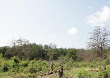
Description: The Gledening Preserve is a recent addition to the Jug Bay Wetlands Sanctuary. It does not have the �wow factor� that the big sister on the south side of Wrighton road has. Although part of the Wetlands Sanctuary you have to strain your eyes to get a glimpse of the wetlands through the trees, even in the winter, and it is considerably smaller than Sis. Still, it has several things giving it a nice up side: 1) It�s free. 2) It is open seven days a week and 3) It is pet friendly. (Our furry friends are not allowed at the Jug Bay Wetlands Sanctuary.) It even has a couple of unique features worth seeing that the main sanctuary does not have: a small sand barren with its Loblolly Pine, Horse Mint, Camphor Weed and Prickly Pear all growing mere feet from each other and a nearly impenetrable Pine Barren, so dense that a swath had to be mowed around it so the visitor can study this unique environment. Described here is a 3.5 mile circumnavigation of the venue. A bit more distance can be had by adding the Maple, Cedar Trails and the upper reaches of the Red Oak Trail. |
|
________________________________________ |
|
Zipped National Geographic. TOPO! GPS and Universal GPX Files |
Trail Notes: To the best of my knowledge the Red Oak Trail is the only trail in the system that is blazed (red) but all trails are obvious and most are signed at the intersections. From the parking area proceed up Red Oak Trail. In 0.2 miles cross a stream on a culvert and immediately turn left onto the Cliffs Trail. You may see some old trails to your right but these have been abandoned. In 0.4 miles come to a T intersection. A left turn leads to a dead end in 0.1 miles but offers the only chance at clearly seeing the wetlands of the Patuxent River. Some poking around in the brush and green briar might be necessary. Return to the T intersection and continue straight, soon passing the Dogwood Trail on the right. (Any right turn from the Cliffs Trail will return you to the Red Oak Trail if you need to shorten the hike.) In 0.3 miles pass the Blueberry Trail, also on the right. In 0.1 miles there is a set of steps carved into �the cliffs� that lead to the site of an old, unusable boardwalk. As of this writing (08/12) there appears to be a project underway to restore it as there are piles of new pressure treated lumber there and some signs of new construction. Maybe there will be a view of the wetlands in the future! In another 0.1 miles pass the Holly Trail on the right. (If you haven�t guessed it by now all but two of the trails are named after trees or bushes.) The trail leaves the sandy lane you�ve been hiking on to the left using a footpath for 0.1 miles before connecting with another sandy lane. At first you might think it is the same one you were on earlier but shortly after turning left onto it you will see the red blazes of the Red Oak Trail. The next 0.2 miles cuts through the sand barrens mentioned in the description. The trail bears off to the left and dead ends but you want to turn right under a lone tree with a picnic table to continue on the Beaver Rock Trail. At this intersection is the densest growth of prickly pears. In 0.2 miles the trail dips down into a trough of sorts. Turn right, climbing up a short hill to regain another flat, sandy lane. In quick succession you will pass Cedar Trail and Maple Trail (a potential shortcut if needed) both on your right. |
|
In another 0.3 miles you will find yourself standing in a mowed swath of grass with the Pine Barrens before you. Turning right is the shortest route but you want to turn left. Study the edges of the Pine Barrens for wildflowers. Birders would probably enjoy this area as well. In 0.2 miles an un-signed trail goes off to the left to the Plummer House. (It has a historical significance but, as of now I don�t know what it is. I hope to find out.) In another 0.1 miles the Blueberry Trail joins the swath from the right. Stay straight on the swath and in another 0.2 miles re-enter the woods, staying on the Blueberry Trail. Pass the Maple Trail in 0.1 miles and in the same distance turn left back onto the Red Oak Trail. Follow this for 0.4 miles back to your car, passing the Dogwood Trail on the right and the Spice Bush Trail on the left.
________________________________________ ________________________________________ Outing Critiques
Name: Adventure
Runner
Hike: Glendening Preserve ________________________________________ |
|
|