|
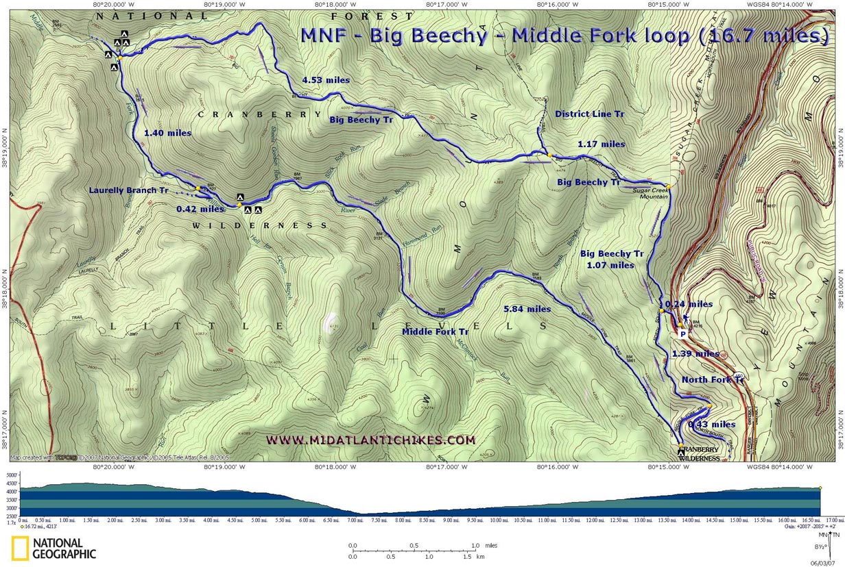
Big Beechy - Middle Fork Loop |
|
|
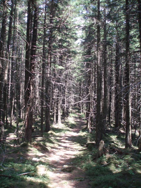
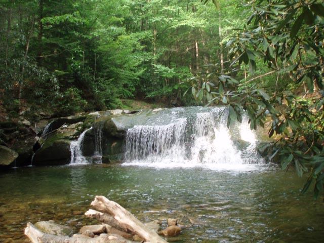
Description: The Cranberry Wilderness is a wonderful place to hike. Don�t go there if you are seeking vistas (You will see them as you drive to it!). If, however, mature forests with towering Red Spruce, Hemlocks, moss covered boulders, wildflowers and tranquil streams teeming with falls, rapids and pools are what you are searching for this is the place. The following hike is described as an over-night backpack. The distance can be extended by adding other trails to it. We used this particular route to set up a base camp and then did a modified version of the nice, leisurely 13 mile Little Fork � Middle Fork Loop described on this site as a day hike on the second day of a 3 day trip. The �Hall of Kings� encountered early on during the hike will set the tone for the rest of the trip. Your stay at the confluence of Big Beechy Run and the Middle Fork of the Williams River with it�s own waterfall and swimming hole will be equally memorable. On the final day try to develop your �sauntering� skills as you gradually climb out of this beautiful river valley visiting places with names like �Hell for Certain� and �Slick Rock� along the way. Take your time. Trailhead sign on the west side of Scenic Highway 150 reads "Big Beechy Trail, North Fork Trail. |
|
______________________________________ |
|
Zipped National Geographic. TOPO! GPS and Universal GPX Files |
Trail Notes: Trails that are totally within the Wilderness boundaries are not blazed. All trail junctions are signed with two exception (the lower terminus of Laurelly Branch Trail with the Middle Fork Trail and the Big Beechy Trail at North Fork Trail). Trails that extend beyond the Wilderness are blazed. From the parking area walk down the road and around an earthen bearm. This was once FR76 which is, like many other old roads in the Wilderness, now part of the trail system. It is now designated North Fork Trail. Pass a kiosk on the right. In 0.24 miles come to an obvious footpath with a vacant sign post. This is the Big Beechy Trail. Turn right onto it and ascent about 150 feet to an old jeep road on top of the ridge. This is the beginning of �The Hall of Kings�. For the next 15 minutes or so you will be surrounded by towering Red Spruce with an understory of moss covered boulders. The rest of the day�s hike will be mostly flat with some gradual hills and a final rapid descent to camp. In about 1.07 miles from the last turn-off the trail leaves the jeep road with a 90 degree turn onto a footpath. There will still be many splendid examples of tall Red Spruce but now they will be mixed with Hemlocks, Black Cherry, Beech and other deciduous trees. The understory will consist of Rhodendron and ferns. Parts of the trail will be lined in wildflowers in season. Keep an eye out for Yellow Clintonia and Mountain Sorrel. |
|
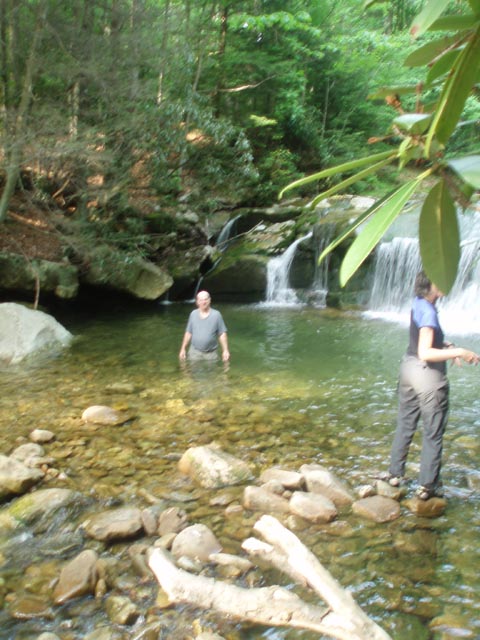
In another 1.17 miles reach the junction with the District Line Trail on the right. Continue straight on the Big Beechy Trail. There will be a couple of gradual climbs as you pass over to 4000 foot knobs. After the last you will begin a fairly rapid descent to the valley as the trail clings to the side of the mountain. Arrive at the junction with the Middle Fork Trail and Big Beechy Run at 4.53 miles from the last trail junction. There is a huge camping area just on the other side of the of the stream. If you are traveling alone or as a couple there is a very secluded campsite before crossing on the other side of the Middle Fork Trail. It overlooks the waterfall and swimming hole.
Assuming you spent the night at this place, recross Big Beechy and follow the Middle Fork Trail upstream. In 1.4 miles pass the junction of Laurelly Branch Trail on the right. There is no sign there as of this writing. Continue onward. In another 0.42 miles come to a small campsite on the right. If you look across the river you might spot the double waterfall of Hell for Certain Run. To its left, on the opposite bank of the river, is yet another great campsite.
Continue upstream. You will soon pass Slick Rock. Once you see it you�ll realize the name needs no explanation. Above this oddity of nature you�ll cross the river for the first time. Shortly after the crossing you�ll find that a large section of the old roadbed has been washed away. There are a couple of cairns here that will help you quickly reestablish the trail. In about another mile cross the river for the second and last time. Here you will also find the roadbed severely eroded in places. In a short distance you�ll find a nice rock jutting out into the river � an ideal lunch spot.
At 5.84 miles from the Hell for Certain camp the trail will make a sharp left and leave the valley. To the right at this point is yet one more nice, but small, campsite. In 0.43 miles merge with the flat and grassy North Fork Trail. Bear left and follow it for 1.39 miles back to the car.
Printable/Downloadable Trail Notes ______________________________________
______________________________________
Name: Ken Knott Hike: Big Beechy-Middle Fork Loop Date: 07/06-07/13 Rating: 4
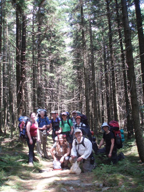
Critique: Another fantastic backpack through the West Virginia Monongahela Forest - this time in the Cranberry Wilderness. Beginning at the Big Beechy trailhead off WV150 we quickly summited following a brief 250ft climb to the enter the 'Hall of Kings', a spectacular stretch of virgin Spruce and moss covered boulders and forest floor. From here for the next 3 miles or so the hike is deceptively easy as hiking is swift on wide trail carpeted with thick spruce needles. Several sections are closely encroached by small spruces and fallen trees which gives a hint of the pain to come... Eventually the trail becomes a series of seemingly continual series of climbs, hops and ducks around, over and through fallen trees, encroaching greenery, thick rhododendron or laurel. Be prepared to take many a 'spruce to the face' as we came to call it. The trail can be difficult to follow at times but it often supplemented by well placed cairns. We lost the trail twice while dodging around fallen tree's and once needed to resort to the gps to backtrack to find the last sighting of real trail. The trail appears to have been rerouted at some point. A final steep hill side decent takes to to the confluence of Big Beechy Run and Middle Fork. The trail here is heavily surrounded by Stinging Nettles and pants are highly recommended in season of greenery. The campground is fantastic featuring many many sites and fire rings. The creeks itself features a beautiful waterfall and a terrific swimming hole. The return ascent up the Middle Fork Trail is a gentle grade of about 2000ft over the course of nearly nine miles. The trail is an old forest or logging road and is generally quite broad and easy to follow. The creek is crossed twice and is often marked by cairns at the rare difficult to follow sections. Again, warning that the trail is heavily surrounded by stinging nettles for at least the first third. Pants are highly recommended. Middle Creek is quite beautiful and features many more campsites, swimming holes, and places to relax. Near the end the trail merges with the North-South Trail for the find mile or so before closing the loop.
______________________________________ |
|
|