|
The next campsite on water is 2 miles and a
nice hill away. Besides the shelter and privy there are
several campsites on both sides of the stream. Perhaps
the largest and flattest is a little further down the AT
where it crosses the creek. It is marked with a sign.
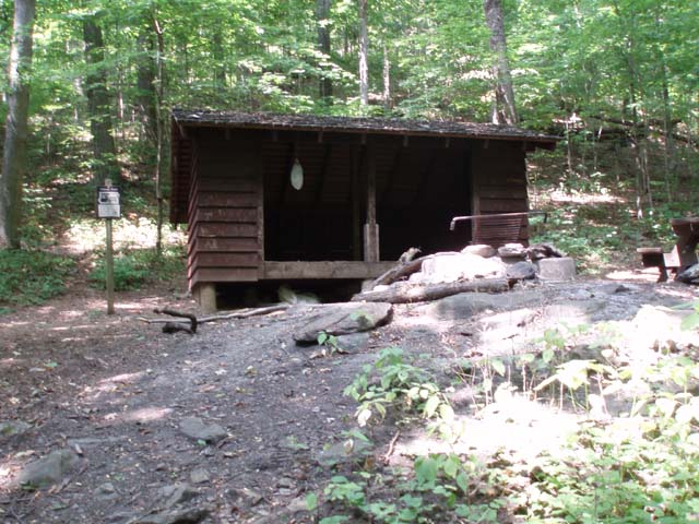
At the Harpers
Creek Shelter spur the AT makes a hard left paralleling the
creek a short distance before crossing it. Follow this route and
in 0.69 miles reach the junction with blue blazed Mau-Har Trail.
Turn right onto it. The trail will be mostly flat at first but
you will eventually climb up and over another ridge before
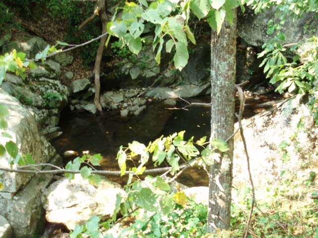
dropping down into the Campbell Creek canyon (1.55 miles from
the last trail junction). There you will find a campsite large
enough for about 4 tents and a yellow blazed spur trail to the
left that leads to a nice swimming hole and waterfall.
After a
refreshing break begin the climb out of the canyon. The trail is
pretty rocky with large boulders you have to step up onto. In
1.10 miles from the swimming hole cross the right fork of the
creek and turn left, following the left fork. You will get a
short respite from climbing, pass a small campsite on the
water�s edge to the left and cross the stream twice before
climbing to the Maupin Field Shelter. This is about 1.04 miles
from the last campsite.
From the
shelter take the main spur trail directly in front of it out to
the kiosk you passed at the beginning of the hike. Retrace your
initial steps back to Reeds Gap and your car.
Critique This
Outing
________________________________________


________________________________________
Name: WV Backpacker
Hike: AT-Mauhar Trail Loop
Date: 11/10/14
Rating: 5
Critique:
This loop was hiked
over two nights, and three days as a low mileage, fun early start to the
week. Approaching the AT trailhead close to sunset, day one was an
approach to the Maupin Field Shelter. Nice easy beginning hike in. Being
Veterans Day weekend, there were plenty of campers, surprising for a
40�F day.
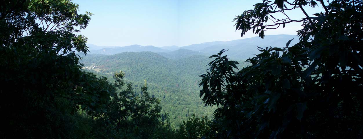
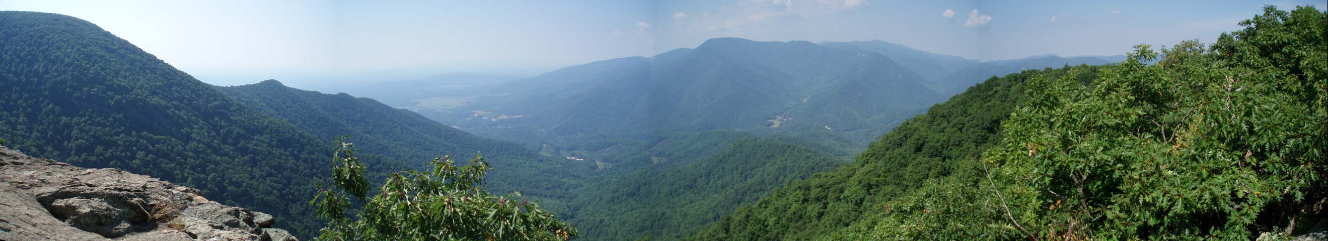
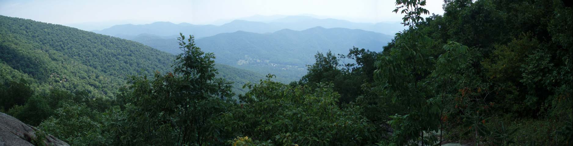
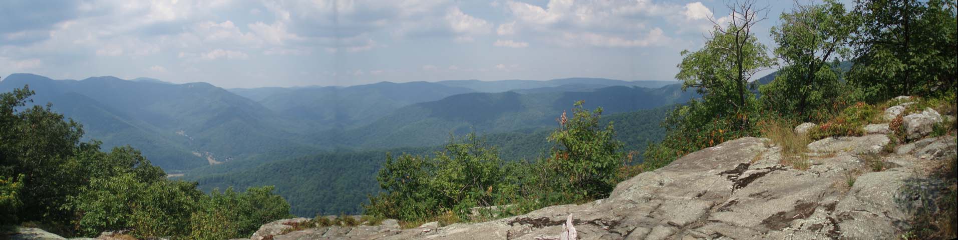
Day 2 began
ascending to Bee Mountain, and on to the first ridge. I feel
this is the best overlook over the entire trip, primarily
overlooking the Priest Wilderness to the south. The trail
continues along the Appalachian Trail, shortly ascending to the
second ridge, the highest elevation of the journey. This ridge
has little exposed areas for viewing. Following the ridge line,
it is another easy reach to the third ridge. I found two
separate areas with stunning viewpoints, both peaceful and
powerful. Note: both the second and third ridges have primitive
camp areas, but with NO WATER. Next comes a long descent. This
time of year makes this easily the most challenging part of the
hike. I highly recommend close supervision of new hikers,
especially those backpacking with weight on their shoulders.
Considerable amounts of leaves hide EVERY nasty rock on the
trail. Lots of Oak trees here drop their acorns, and it happens
to be a very sheltered, quiet area for bears to dine. Harpers
Creek Shelter is also sheltered well, both from the wind and the
sunshine.
The hike out is
easy going southbound on the AT, as well as the beginning of the
northbound Mau-Har hike. Beyond the waterfall/swimming hole
area, it becomes a hike that requires patience, and several
short breaks. All uphill. Once you start seeing a few firs, you
will find yourself approaching the Maupin Field shelter.
________________________________________
Name: Terry Reifsteck Hike: Mau Har Loop
Date: 11/3012
Rating: 5
Critique: Plan on 9 hours of the best Virginia Highlands hiking this
side of Interstate 81. I strongly recommend starting this trek from Tye
River, because what goes up will indeed descend. My trip took 10 hours
with 9 on the trail and 1 for lunch and stops. Since I'd been up Three
Ridges before from Tye, it seemed prudent to hike this loop clockwise,
if only to avoid the monster climb you'll encounter going against time.
Weather was perfect today, with temps in the low 30's at the start and
overcast sun for most of the day. Mau Har is interesting to say the
least. From the junction at AT south, plan on a park like lope for the
first 30 minutes. Then, the ridge in front of you begs for a tunnel but
alas...chug up this hill only to descend another 500 feet into the next
drainage. Mau Har must be Latin for Rocky, Steep and Unrelenting. But,
don't lose hope. As wild as this ride gets in the middle, on the other
end you get to lope through the park again. The rocks quit, the gradient
eases and you'll find yourself at Maupin Shelter within 4 hour of your
Tye River start. The rest is all down hill, with the exception of a
minor climb to the top of Bee Mountain. Nice overlooks, lunch spots and
not much water between the shelters. Go out there and enjoy this one.
That's why it's there.
________________________________________
Name: Sam A
Hike: AT-Mau-Har Trail Loop
Date: 9/23/12 Rating: 4
Critique: Nice hike! Got in late and slept at the Maupin Shelter. Woke
up at 530 to catch some stars and packed along the AT with a headlamp to
find a decent place to catch the sunrise. Though tough at times, I
thought it was not too bad if you're in shape. I got back to the shelter
via Mau Trail in about 7 hours (including a 1 hour roundtrip to go back
and get a knife I left at a vista), so definitely doable in a day if you
haven't much time and are up for a challenge.
Only place I really got lost was at the big campsite at Campells Creek.
I went along the yellow blazed trail to the waterfall then couldn't find
the Mau Trail again... it's dead ahead from the sign post, you'll see
the blue blazes on the rocks ahead of it.
________________________________________
Name: jenny s
Hike: Three Ridges loop
Date: 4/14 to 4/16/2012
Rating: 5
Critique: Did a 3-day loop starting at the south end on the AT by the
Tye River. Recommend the campsite on the ridge above Maupin Field
Shelter (on the AT side) for some nice breezes. Campbell Creek is
beautiful and beautifully cool. I'd prefer to do this counterclockwise
any day. Great views and sore muscles and healthy lungs at the end of
the trip.
I have not even one photo of any of it because I lost my camera on the
AT portion of the trail between Chimney Rock and Bee Mountain (probably
north of the high point). Offering a monetary reward for its return as a
functional camera. It's a pocket Canon SD1300 digital (http://reviews.cnet.com/digital-cameras/canon-powershot-sd1300-is/4505-6501_7-33975897.html)
and has about 200 to 300 photos on it. It's in a small black carrying
case with a thin shoulder strap. Find it and I'll put some money toward
a new camera for you. Contact me at [email protected]. Thanks.
For the plant and wildflower fans...saw HILLSIDES of trillium especially
along the Mau-Har, also dutchmen's breeches, pink ladyslipper (just
starting), dogwood, solomon's seal, fire pinks, blueberries starting to
bloom (!), LOTS of poison ivy, may apple, spider wort, wild geranium,
even a couple of fallen tulip poplar flowers, and showy orchis.
________________________________________
Name: Kelly and Linda
Hike: AT/Mau-Har Loop
Date: 8/8/2011
Rating: 5
Critique: My husband and I left the parking area after a big lunch and
water. We loved the hike but wish we had the trail map. It was very
strenuous but exhilarating!
We ended up hiking out about 3.5 and back. We were tired! We would like
to go back and do this trail in 2 days.
________________________________________
Name: Alex Dean
Hike: AT/Mau Har Loop
Date: June 17-19, 2011
Rating: 5
Critique: We started out with a group of Boy Scouts on Friday evening
from Reed's Gap parking lot. We hiked into Maupin Field Shelter and set
up camp around 11:30pm. Our plan was to hike up to Three Ridges and have
lunch, then down to Harper's Creek Shelter, restock on water, hop on the
Mau-Har and hike to Campbells Creek to camp at the waterfall, then hike
back to Maupin Field Shelter, meet up with the younger Scouts and hike
back to the cars at Reeds Gap. Well, when we got to the camping area at
the waterfall, the campsite was full. Do we turn back to Harper's Creek
Shelter or do we press on to Maupin Field Shelter? We chose to press on
to Maupin Field Shelter. Boy was that a strenuous hike!! We made it back
to the shelter around 6:30pm very tired. Early to bed and back out to
the cars Sunday morning. If I knew we would be making the entire 14.4
mile loop in one day, I would have just carried the essentials for a day
hike. It would have been a lot easier on the the four dads and the four
12 year old scouts carrying their full camping backpacks. The kids
actually held up better than the dads! The boys had a great feeling of
accomplishment and they will probably never forget this experience. I
know I won't!! What a great trip!
________________________________________
Name: Travis Martin
Hike: AT/Mau-Har Loop
Date: 10-13-09
Rating: 4.5
Critique: Started at six thirty as the sun was coming up. The first
several miles were easy and the up-hills weren't too steep. Saw a huge
pile of fresh bear pooh which had me a little bit on edge. The long
descent down Three Ridges is when it started to get a little bit tough,
because the trail is made up mostly of sharp, uneven rocks and roots.
Hardly a single footfall is on flat ground, so its crucial to have boots
that can take a beating.
Stopped for a brief rest at Harpers Creek shelter. The creek was almost
completely dry but it looked like a good place to camp if you are
backpacking.
Starting up the Mau-Har trail started to get really tiring and this was
the rockiest stretch, as well as steepest as you climb out of the Creek.
The leaves are turning up there right now so that made for some great
scenery. The final 3 miles were a killer on my feet and knees but I made
it back to the car at 3:30, 8 hours after i started. way faster than I
expected but I didn't make any extra long stops. I was going mighty slow
for the last mile though. I was pretty beat. This isn't a trail for
people who are out of shape or ill equipped.
________________________________________
Name: CRaig
Hike: AT- Mau-Har Trail loop
Date: Aug 10-12, 2008
Rating: 5
Critique: This was a great experience! MY brother and I hiked it (began
mid-day Sun and ended mid-day on Tues) and broke it up over 3days and
two evenings. This allowed us to stop when we wanted to and enjoy the
incredible views and scenery. This also allowed us to go hit the "hay"
early and wake up late each morning (later than a work day). Like the
other postings here, it is a tough workout on your legs (I couldn't
imagine doing it in a single day, unless you are hiking for a
workout/exercise and not for pleasure.
All the trails were marked well and all but two places were difficult to
maneuver due to a downed tree.
We took the AT trail first then met up with the Mau-Har Trail the second
part. The toughest part of the trail was between Harpers Creek Shelter
and second Campbell Creek campsite, then it leveled out on the way back
to Maupin Field Shelter.
We saw deer our first morning at the Maupin Field Shelter area (lots of
separated camp sites) and then in the same area the next afternoon.
Plenty of wild animals passed by during the night at Campbell Creek camp
site. Possibly due to Campbell Creek actually having cascading water for
us and the local inhabitants to drink from. My brother's dog alerted us
during the evening.
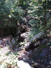
Due to little rain the previous weeks, Harper's Creek was virtually dry
except for a small pool of water due to light rains on our first
evening. IF the area doesn't get much rains you may want to stock up on
your water supply for the Hike along the AT.
IF you are allergic to bees, don't stop at Bee Mountain to see the
views, You don't want to have any medical conditions while on the trail.
Enjoy your hike!
________________________________________
Name: B. Gordon
Hike: AT-Mau-Har Trail Loop
Date: 5/10/2008
Rating: 5
Critique: As advertised, this is a very strenuous hike. We did it as an
overnight, staying at the Harpers Creek Shelter area and were the only
ones camping there. The creeks are really flowing right now so if you
can break free soon get out and see them. From other reviews it seems
that the creeks can turn to a trickle quickly as we get into the summer
months and no rain. The trillium and rhododendron are blooming and were
beautiful. Don't miss the yellow blazed side trail to see the waterfalls
on Campbell Creek on the way up the Mau Har Trail, a worthwhile side
trip. I highly recommend using trekking poles for this hike. An
excellent hike and even better done over 2 days.
________________________________________
Name: Nicholas
Hike: AT/Mau-Har Loop
Date: 2/16-17/08
Rating: 4.5
Critique: Great hike, tremendous overlooks, always going either up or
down. About half hour into the hike, while resting on a large boulder,
we were lucky enough to see a doe and fawn come into view and then
(mistakenly on their part) nearly run straight into us as they sensed
our presence, getting to within about 7 yards before veering off course
and into the woods.
There was good water at Maupin Fields shelter - we started very light on
water to conserve the weight for a bit, and then filled up there.
Campbell Creek was running strongly. Continued on the AT after Maupin
Fields, and the trail climbed almost continually, with a few flat spots,
up to the summit of Three Ridges. With the leaves gone, the views were
excellent along the way. Before the summit, we saw a print from a large
cat of some type, probably close to three inches long from heel to tip
of the claws, but we never saw the print's owner.
After the summit came the most difficult part of the day in the
switchbacks. The problem was that on large sections of the trail, there
were thick beds of leaves sometimes covering the trail up to a foot and
a half deep. They were very slippery, and covered up some pretty big
rocks. You almost had to shuffle your feet as you went through. Also,
this section of the trail was a bit difficult to follow because it was
invisible beneath the leaves and there were not many blazes from the
summit south to Harper's Creek.
Harper's Creek Shelter is in great shape. The creek was flowing
strongly. The only drawback was there was no firewood around, so rather
than two hours of gathering wood and carrying it some distance, we went
without a fire.
The Mau-Har was the most difficult aspect of the loop. There were a
number of major tree falls which completely blocked the trail. Tree
falls by Campbell Creek required some difficult detours, one of which
consisting of not-too difficult rock climbing. Once the trail moved away
from the water, it got easier.
Hike would have been a 5 if not for the tree falls which added
unnecessary difficulty to an already difficult hike.
________________________________________
Name: Ian
Hike: AT/Mau-Har, 3 Ridges Loop
Date: 8/07
Rating: 5
Critique: A friend and I did this loop. We started at the Tye, went
north on the AT and came back vai Mau-Har the next morning. This
direction is extremely strenuous. Get your pack as light as you can and
get ready for lots of switchbacks, unending relentless switchbacks.
First hike I've been on where my calves literally stopped working for a
while.
The trail has great views. There were a surprising amount of people on
it the weekend that we went but I must say it was a surprisingly
beautiful weekend to go hiking.
We split the hike at the Maupin Field Shelter where the AT and Mau-Har's
northern most intersection is, 1.6 miles from the Reed's Gap parking
lot. Taking the Mau-Har back the next morning was nice. Not nearly as
painful as the way up and over the three ridges.
________________________________________
Name: Jay GA>ME05
Hike:
AT - Mau-Har Loop
Date: 7/4/07
Rating: 5
Critique: This makes for a spectacular and rugged day hike. Shed the
heavy backpacking equipment, and all of this elevation change goes much
easier. We did it in about 9 hours, at a leisurely pace. Be sure to
climb down to the lovely swimming pools and waterfall on the Mau-Har
section. Thru-hikers, if you take the blue blaze and skip 3 ridges, I
think it'll give you a good taste of hiking in the north. LOVELY
COUNTRY!
________________________________________
Name: Treebeard
Hike:
AT-Mau-Har
Date: 4/21/07
Rating: 5
Critique: This was a great backpack. The one word that I have used to
describe the hike is "relentless". This is because you are either going
up or down (very little to no level walking) on some difficult terrain.
Just when you are catching your breath from a challenging uphill, down
you go. I guess this is what you need to do to cover the almost 8000
feet of elevation change over 14 miles. The vistas are numerous and some
are spectacular. Hiking upward along a cascade was beautiful with nice
waterfalls and flora along the way. It was also nice to see the
beginning of the wild flowers starting to pop.
________________________________________
Name: Tony
Hike:
AT-Mau-Har
Date: 4/21/2007
Rating: 5
Critique: This is an excellent hike with many beautiful vistas along the
AT, and small waterfalls and pools on the Mau-Har. The elevation gain
for the entire circuit is nearly 4,000ft, so with a backpack of 30+
pounds this is a very strenuous hike. However, definitely a must-do for
any serious backpacker in the Old Dominion. You just can't beat all the
scenery in this part of the state!
________________________________________
Name: Rick Hike:
Three Ridge Trail/Mau-Har Trail
Date: 10/13-10/15/06 Rating: 5
Critique: Thank you so much for this site. I went on this hike about 5
years ago and I couldn't figure it out until I found it here. So, thank
you first of all.
The map was helpful and your description was just as helpful. A couple
things for improvement. The Route marker is VA Rt 664 not 644.
However, mile marker 13 was precise. Also, we weren't sure if the
distance on the topo provided were crow's flight or actual distance in
steps.
It was a perfect weekend provided one had an adequate sleeping bag. I
did not but my buddies had great sleeping bags. Needless to say, I
froze, they didn't. I just didn't think it would be that cold. The
rest of the trip was great! We took pictures and videos of our
adventure and met a few people along the way. That's it for now. I'll
have to write more later. Thanks!
The Rt # has been changed. All trail
segment distances are "as walked".
________________________________________
Name: Mad Hatter
Hike:
Mau Har-AT
Date: January 01, 2000
Rating: 5+
Critique: Did this hike as part of a backpack on Y2K evening (on
the way down we heard Japan had passed into 2000 without
problems) to prove camp stoves are not affected by ushering in a
new century. We parked at a road at the Harpers Creek Shelter
end of the AT and camped near that shelter. On the overcast
second day we did the circuit with its strenuous climb up to
Chimney Rocks and along Three Ridges. Views were clear though I
could only remember Chimney Rocks. We ate lunch at the Mau Har
shelter, and ventured to the Mau Har Trail, not knowing it was
not the pleasant walk presupposed by the map. Yes, rocky
boulder-strewn footing, but a nice creek, with water at that
time. When we reached the southern end and wanted to exit the
drainage, it seemed like we went up, and up, and. I let out a
colorful word about the continued relentless uphill since at
that time we were tired. Finally the AT appeared and we
joyfully returned to our campsite. Though no rain, the over
cast kept the area warmer, and on our return day the sun
appeared. Since my friend relished steep uphills, I told her
The Priest, the next uphill south from where we parked would
suit her.
________________________________________ |