|
Hog Camp Gap to Reed's Gap Shuttle BP |
|
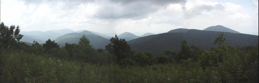
Description: This is without a doubt the most challenging trek on this website as of this posting (07/20/06). Over 24 miles (if you choose the short version described here) you�ll gain 5100 feet in elevation and lose 6300 feet. 3100 feet of this will be at the rate of 800 ft/mile as you descend the Priest. The rewards: outstanding views from places like Tar Jacket Ridge, Spy Rock and the Priest, a riot of wild flowers throughout the spring and summer, the Scenic Tye River and the rugged and serene gorge of Campbell�s Creek (short version). This trip can be completed over 3 days. Some have described it as a 4 day trip. We will note the places we stayed at over 3 days but feel free to adjust the daily distances to fit your desires/needs. Also, if you want more distance (about 2.5 more miles), elevation gains (Add another 1000 feet or so while subtracting 1000 feet of loss.) and views (at least 3 along the Three Ridges) you can forego the Mau-Har Tr and stay on the AT all the way to the end. |
|
Google Custom Directions to Car Drop-off at Reeds Gap The parking area is at the intersection of the Blue Ridge Parkway at VA RT664. Google Custom Directions to the Hog Camp Trailhead Use the following directions in conjunction with the above map to reach the trailhead.
________________________________________ |
11 X 17 best
Zipped National Geographic. TOPO! GPS and Universal GPX Files |
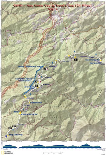
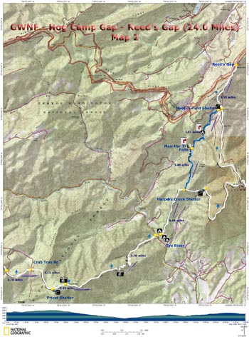
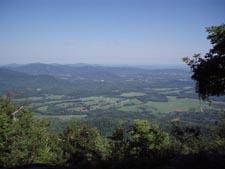
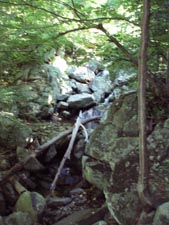
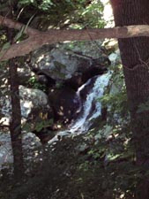
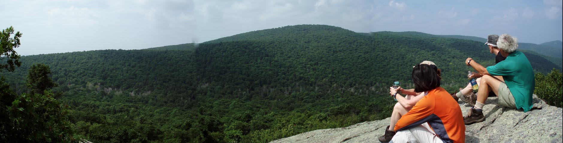
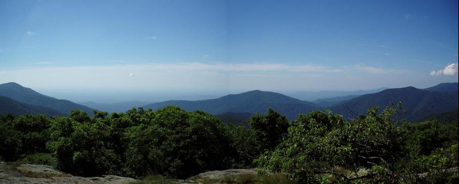
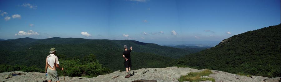
Trail Notes: As always, the AT is blazed white. Side trails and spurs are blue. All trail junctions are signed. All campsites and shelters have water unless otherwise noted. The shelters have privies. Map 1: From the AT crossing proceed north through an old orchard/pasture. You�ll begin ascending through some very young woods. Before too long you�ll break out into a grassy clearing and your first view of the surrounding peaks and ridges. You�ll soon be back in the woods but in a few hundred more yards you�ll come to another field with even greater views. [If doing this hike in the summer keep an eye out for a viney plant that carries small, nodding purple bell-shaped flowers along this stretch. It is called Leather Flower (Clematis viorna). You�ll also find some amazingly bright red Gray�s Lily.] Descend from the ridge and in 1.84 miles from the start pass through Salt Log Gap. Cross Wiggins Spring Rd and Rt634 and begin another ascent. In another 1.18 miles cross Alhambra Rd and in another 0.5 miles cross Greasy Spring Rd. Climb some more and soon pass blue blazed Lovingston Spring Tr on the left. In 0.97 miles from Greasy Spring Rd reach a nice but dry campsite on the left. A footpath beyond it takes you to a rock outcrop that offers a nice view of North Fork valley below and is a great break spot. It�s not marked on the PATC map so I named it after my nephew, Eric. If you know Eric you know he needs a rock named after him. Continue north on the AT. In another 0.78 miles descend to North Fork. There is good water here and a campsite to the left of the trail just after crossing the stream. Look for a big tree growing on top of a massive boulder. In 1.79 miles reach the Seeley-Woodworth shelter. This is where we camped the first night. It is a little over 7 miles into the trek. There is room to fit an army of hikers, a better-than-usual privy (as privies go) and a piped spring. Note: PATC map 13 shows the Livingston Spring Tr rejoining the AT further north. In actuality, if my memory serves me correctly, it rejoins the AT here. Continue north and in 1.11 miles cross an un-named road and in another 1.2 miles cross Fish Hatchery Rd. From here climb to the junction of the Spy Rock Spur Tr. There is good camping here and at the base of the rock but there is no water. Follow the spur (right or straight) and drop your packs at the last campsite. A short footpath to the right leads you to the rock scramble that culminates in a 360 degree view of your surroundings. You can see where you�ve been as well as where you will be. You can see all of the peaks in the �Religious Range�: The Priest, The little Priest, The Friar, Little Friar, The Cardinal �. If you brought your map and a compass up with you identification of at least some of them should be easy. Return to the AT and continue northward. In 2.18 miles cross Cash Hollow Rd Map 2: In 0.78 miles cross Crabtree Rd. If you wish you can stash your packs and turn left onto the road for a short distance (about 0.25 miles) and visit 200 ft Crabtree Falls. I�ve not been there yet but I�ve been told it�s pretty impressive. Expect it to be crowded almost year round. Continue on the AT. Climb for 1.11 miles to the Priest shelter. Stop here and get water. Take lunch and/or a break but another good vista is another 0.32 miles further up the peak if you have the energy to go a little farther. There are 2 unmarked but obvious side trail on the left. The second one is the best. It offers a 180 degree view to the west. |
|
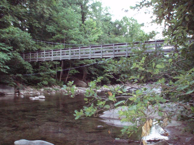
Shortly after this visit you�ll crest the summit of the Priest and begin a steep descent. For the next 3.7 miles you�ll drop at an average rate of 800 ft/mile. The upper part is the steepest and rockiest. There will be steep drop-offs on either side of the trail. There are 2 views of the Tye River valley as you descend. About halfway down cross Cripple Creek. This is a good spot for a cool refreshing break. In another 1.5 miles reach a parking lot and Rt56. Cross the parking lot on a diagonal to the right and then the road. You�ll see an obvious footpath that leads to the Tye River. Cross the river on a very well constructed suspension bridge. There are adequate campsites to the left (maybe 4 tents) and to the right (2 large co-joined sites that can hold about 8 tents each. These are adequate accommodations but, being close to the road, not the best. Logistically though it�s an ideal spot. You have already hiked about 11 miles if you started the day at the Seeley-Woodworth Shelter. The next campsite, if doing the short version, is about 3 miles further over some very rugged terrain and the camping is very limited there. If you don�t mind adding a little out-and-back mileage the ascent from the river to Harpers Creek shelter is about 2 miles but it is very steep. If staying the night at Tye River, expect local residents to campout nearby and visit the swimming holes. Things seem to quite down come nightfall. If you�re doing this trek during the non-swimming season this might not even be an issue. Assuming you spent the night at Tye River start a long, steep climb through the Three Ridges Wilderness. In 1.46 miles reach the junction of blue blazed Mau-Har Tr (short for MAUpin Field � HARpers Creek). To complete the long version stay on the AT and climb some more. You�ll pass the Harpers Creek shelter and visit at least 3 vistas before arriving at the Maupin Field shelter. To complete the trip as described here turn left onto the Mau-Har Tr. Initially the tread will be relatively flat but you will once again soon find yourself climbing steeply over a ridge. The trail will be quite rocky at times. Descend to Campbell�s Creek at 1.48 miles. There is a campsite capable of holding about 4 tents at this point and a small waterfall and swimming hole about 0.1 miles down a signed spur trail to the left. Continue up the Mau-Har Tr for another 1.51 miles. For the most part the trail follows the stream. In a few spots you�ll have to navigate up some big rocks and cross the stream 2 or 3 times. You�ll pass another streamside campsite along a relatively flat stretch of old woods road before turning right and climbing a steep footpath to Maupin Field shelter. The shelter is OK but you may actually find it more comfortable if you relaxed at one of the nearby, signed campsites. The spur trail that leads to the campsites (left and right joins the AT at a kiosk on a service road. Turn left onto the road but shortly turn right onto a footpath. Over the next 0.7 miles you�ll climb gradually over the last hill of the trip. The last 0.8 miles is either flat or downhill. You�ll know you�re close to the end when you find yourself walking along the edge of a large meadow to your left. Soon find yourself at Reed�s Gap and your awaiting vehicles. Printable/Downloadable Directions and Trailnotes ________________________________________
________________________________________
Name: Brad Hike: Hog Camp Gap to Reeds Gap Shuttle (modified) ________________________________________
Name: Matt
Hike:
Hog Camp Gap - Reeds Gap ________________________________________ |
|
|