|
|
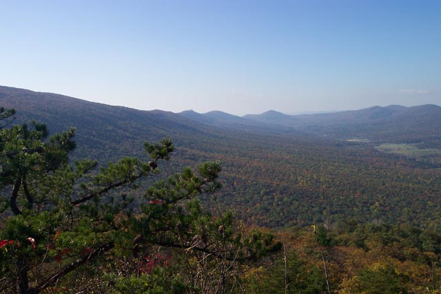
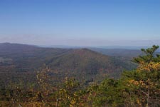
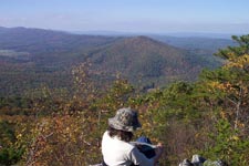
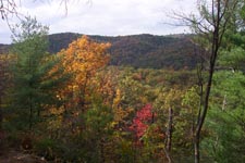
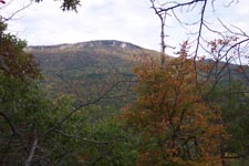
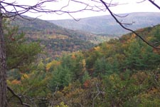
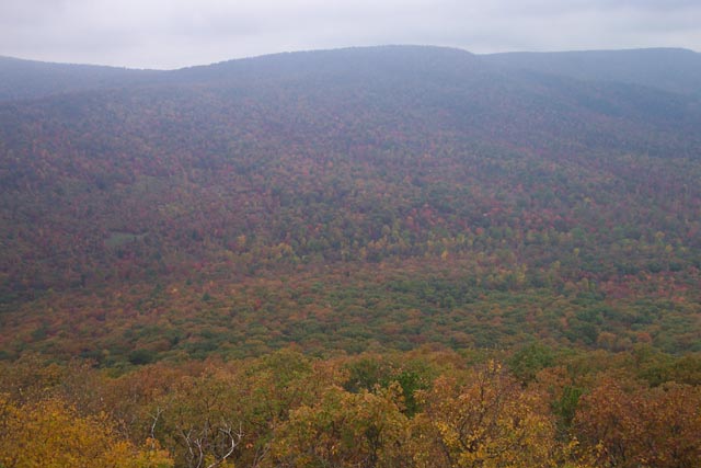
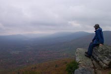
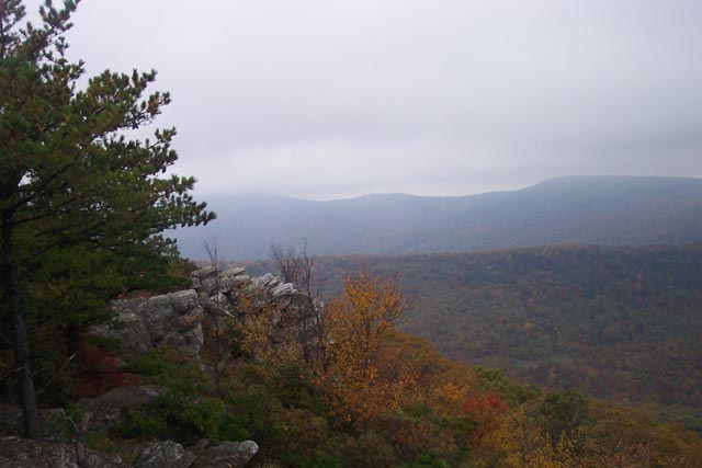
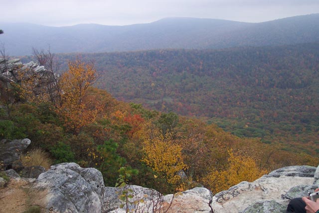
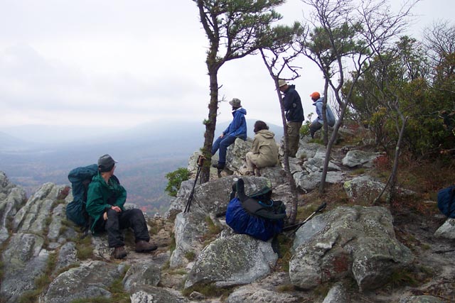
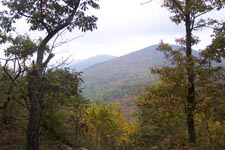
Circumnavigation of Trout Run Valley Description: This is a fairly strenuous 27 mile backpack on the Great North Mountain in GWNF, WV. The distance may be more if the need to deviate from the course to camp near water arises. There are many ridge-top springs and streams but these may be dry during the hotter months. Be prepared to take alternative actions. In all you will gain and lose over 3400 feet of elevation through the course of the trip. Your reward, weather permitting, Is a chance to visit up to eight grand vistas, six of which view Trout Run Valley from different perspectives. The hike starts at the kiosk in the Wolf Gap campground. The Mill Mountain Trail is part of the Great Eastern Trail (GET). |
|
________________________________________ |
|
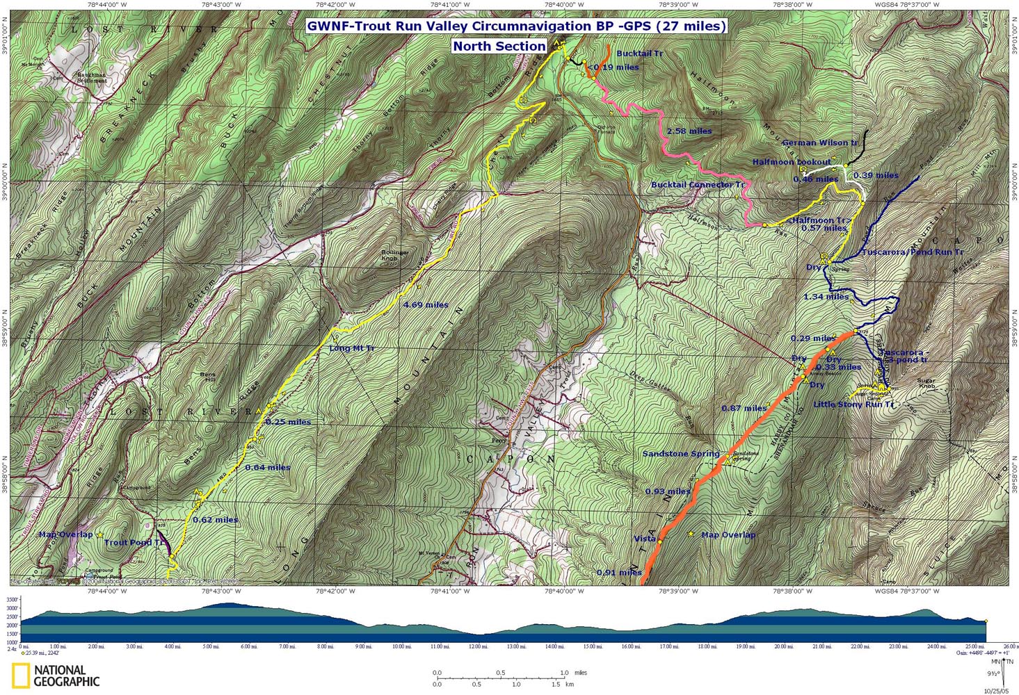
Printable/Downloadable North Section Map
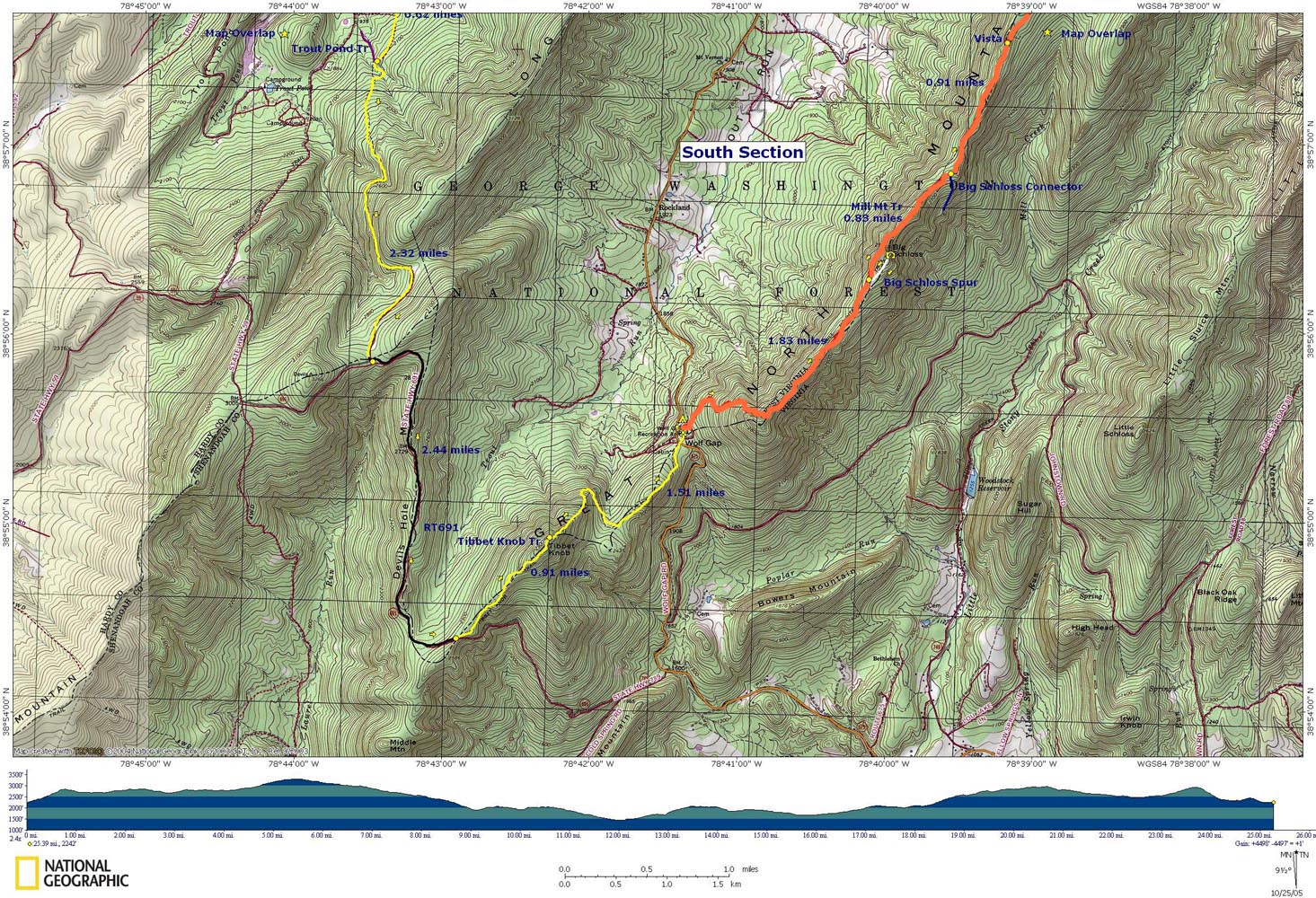
Printable/Downloadable South Section Map Zipped National Geographic. TOPO! GPS and Universal GPX Files GPS Text File For Non-TOPO! Users
|
Trail Notes:
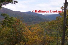
Day 1: From the day use area walk around the campground loop. Either direction will get you there but turning right out of the day use area is the shortest. If you go that way turn left onto the orange blazed Mill Mountain Trail. Climb, steeply at times, for about one mile before reaching a saddle in the ridge. Pass 2 vistas on the right with views of Little Sluice Mt and the Massanutten Mt further east. In 1.83 miles from the beginning come to the junction of the Big Schloss Spur Trail (White blazed). A 0.5 mile round trip will take you to a 270 degree view. Return to the Mill Mt Trail and continue north. In another 0.83 miles pass the blue blazed Big Schloss Connector Trail. In another 0.91 miles arrive at another vista overlooking Trout Run Valley. From there it is another 0.93 miles to Sandstone Spring where there is good camping and reliable water. More camping w/o water can be found 0.87 miles further and yet another dry site about 0.35 miles further. In about 0.29 miles from the last campsite arrive at the junction with the Tuscarora/3 Pond Trail (blue blazed). If you wish you can turn right and find camping at about 0.5 miles either on the Tuscarora or Little Stony Run Tr. There is a spring just beyond Sugar Knob Cabin on the latter. This hike has you going straight ahead onto the Tuscarora and in 1.34 miles arriving at a campsite above Pond Run, the junction of yellow blazed Halfmoon Tr and a short white blazed trail that leads to a vista. Water can be found about 1 mile down on the Pond Run/Tuscarora Trail from the campsite. Day 2: From camp turn left onto the yellow blazed Halfmoon Tr. In 0.57 miles arrive at the junction of the white blazed Halfmoon Lookout Spur. You may wish to stash your packs here since you'll be returning this way. Take the Halfmoon Spur Trail all the way to the end, passing purple blazed German Wilson Trail (no sign) along the way. There is also a cliff view below the main summit. Check them both out. Return to the junction with Halfmoon Trail, recover your gear, and descend about 1 mile to Halfmoon Run, water, camping and the junction with pink blazed Bucktail Connector Tr. |
|
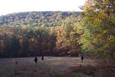
Follow Bucktail Connector Trail through mature forest, second growth thickets and grassy meadows for 2.58 miles and the junction of orange blazed Bucktail Trail. Turn left onto it and follow it to a forest loop road. Turn left, cross Trout Run Road and pickup yellow blazed Long Mountain Trail. Follow Long Mt Trail north for a few hundred yards and then turn sharply left (south) onto an old woods road. The trail will leave the road and pass through a grassy area near a campsite and cross Trout Run. Cross the stream on a newly constructed bridge. Climb steeply up a footpath. The trail eventually becomes a woods road and switchbacks up Cherry Ridge. At about 1.87 miles from the trailhead pass a grassy clearing on the right and an old woods road on the left (the old Crack Whip Furnace trail, I believe) before arriving at yet another large grassy clearing. The continuation of the trail is a grassy woods road on the right side of the clearing. In about another 1.2 miles the fun begins as you reach a 200 yard long rock field. There is no trail but the trees are blazed rather frequently. Take your time! Once across you�ll return to a relatively smooth footpath. In another 0.3 miles come to yet another grassy clearing. A woods road goes right and downhill. You want to turn left and follow the blazes. You'll cross a couple of streams (not always flowing) with a grassy area in between suitable for camping (There is no fire ring.). In 0.64 miles from the last stream there will be another grassy opening to the right of the trail. This is a great campsite under the shadow of Ben�s Ridge complete with a fire ring. There is a small spring in the woods behind the clearing (walking towards the ridge) that some one has damned up. A better water source is a stream that crosses the trail less than 100 yards south of the campsite. This stream is not shown on any maps I�ve found but it does exist although it can dry up in the hot summer months. Day 3: As you travel south from the campsite you will pass one more woods road on the right and begin to ascend Devil�s Hole Mt. at 0.62 miles from the campsite come to the intersection of purple blazed Trout Pond Trail. Turn left staying on Long Mt Trail. As you climb you will be following a narrow footpath. As you reach the crest of the mountain the trail will once again become a woods road. Pass several grassy clearings on the left and in 2.32 miles from Trout Pond Trail reach FR 691. Turn left on FR 691 and walk 2.44 miles to a parking area on the left with a campsite and fire ring. Look for yellow blazes marking the beginning of Tibbet Knob Trail. Follow the blazes (some will be on rocks) along the spine of the ridge until you reach the overlook in 0.91 miles. Long Mt will be to your left, Halfmoon Lookout straight ahead and Mill Mt with Big Schloss on your right. Follow the yellow blazes and scramble/slide/sush-on-your-butt your way down the steep face of the knob. In a hundred yards or so you will regain a more normal trail that descends to the Wolf Gap Campground and your awaiting vehicles (1.50 miles from the top). On the way down you will cross over a small summit which affords nice views of Big Schloss and Little Sluice. |
|
__________________________________________________________________________________
__________________________________________________________________________________
Name: Dave Outing Critique: My daughter and I just finished this hike, exactly as described, and loved it. We have very little experience and found these detailed descriptions extremely useful and accurate. It was very challenging for us, but very rewarding. We did encounter a rattlesnake near Half Moon. The thistles/thorns were very thick a little north of Big Schloss and we sort of wished we were wearing long pants on that day. Also, it rained very hard the morning of the third day, so as we climbed away from Trout Pond up Devils Hole the trail pretty much became a stream carrying all the rainwater down the hill. __________________________________________________________________________________
Name: Greg S
__________________________________________________________________________________
Name: Jake Hike: Trout Run Valley Circumnavigation Date(s): 10/17-19/14 Rating: 5
Outing Critique: Great hike, many beautiful views. The trail notes are spot on, and easily followed the trial. One thing to note is that the white-blazed short trial down to the vista at the first night campsite is not really blazed anymore, and we actually couldn't find the trail at first. From the intersection with the sign, turn left and pass between the two fire rings. Head straight down over the hill and you will start to see a small trail. I would also mention that there are not many good campsites on the Long Mountain Trail, other than the large field that was noted here (I couldn't find the spring it mentioned). There are spots that could work, but didn't really see any additional developed sites. __________________________________________________________________________________
Name: Mike G. Hike: Trout Run Valley Circumnavigation Date(s): 07/18-20/14 Rating: 4
Critique: We did this hike in the direction laid out in the narrative. Our first day, we left Wolf Gap at 9 am, and headed north. Be forewarned that the well pump at Wolf Gap is broken, and has been since last fall. After a steady, but not too grueling climb, we reached the side trail where the vista was awesome from Big Schloss overlook. Back on the main trail, we reached the Sand Spring area, which was the first water we spotted that day. The water was flowing well, but had an odd chalky taste despite being filtered. We then reached the Tuscarora trail intersection, where there was no sign pointing out the TT, but it was obvious to go straight since the blue blazes were easily spotted. There was a confusing intersection where a steep jeep trail comes down from the left. Do not go that way. Just a little ways past that jeep trail (perhaps a half mile tops), we arrived at Day 1 camping at the intersection of Half Moon and TT. Good campsite, and as noted below in another critique, plentiful water flowing just before the bridge you cross before getting to the camp. Day 2, we went on down the Half Moon Trail and a couple of us hung up our packs on nails in the tree at the intersection and went off on the Half Moon overlook trail, which was an easy mile each way...there was some sort of small outlook structure up there built of stone, and the view was nice, although not as good as the Big Schloss view. Continuing on, generally downhill, we reached a really nice campsite with a creek..this was the intersection of the Bucktail Connector Trail. I think this would be a great alternative Day 1 campsite if you wanted to push on a little further than where we camped. We followed the directions given, and reached the end of the Bucktail Connector. The left onto the orange blazed Bucktail trail is more like a merge, and that trail is a very wide grassy fire road. Go down just a quarter mile or so, and reach a nice set of benches and take a break! Once we got across Trout Run Road, we began a big ascent up Long Mountain Trail. Much of this trail is an old fire road, and there are lots of grassy clearings, as described...the rock field is pretty daunting, yet lots of fun. Eventually you will reach a creek (I believe the one MR Hyker says is the last creek .64 miles before the Ben's Ridge site). There is a really nice site on the right just after that creek, back in the woods a ways, with a big fire ring. It would be a great Day 2 site if you are too weary to make it to his Day 2 site at Ben's Ridge. We went on to Ben's Ridge, which was pretty decent. A big clearing, but definitely slanted slightly, with a fire ring to the right. No sign of a spring anywhere, but a nicely flowing creek is just south of the clearing. Not obvious, but as you walk south, you will see the creek getting a little closer to the trail (it never crosses the trail). Day 3...from the Ben's Ridge site, it's a pretty steady and long climb, but eventually we came to a forest road and turned left...there is a nice campsite at this junction, but no water. Hike about 2 miles on this gravel road, and you will come to a very unceremonious trail head for the Tibbet's Knob trail on your left. A trash filled fire ring, and space for tent are there. The trail is pretty rocky and gets sketchy, but it is well blazed...eventually you reach the Knob, and it is one of the best views I can remember. You then descend, very steeply for a while, then the trail becomes more gradual. Just when you think you are about to reach Wolf Gap, you have to make one more pretty steep climb up a hillock, with great views as your reward. Then a short downhill hike afterwards puts you back at Wolf Gap. A great hike overall, and I think going in the Fall for color, or in the early winter or late winter before the trees leaf out would make it even better as you would have great views from the ridges.
__________________________________________________________________________________
Name: Hard Core and Wooly Bully Hike: Trout Run Valley Circumnavigation Date(s): 10/19-21/13 Rating: 5+
Critique: We opted to do this hike as a clockwise loop (vs. the CCW loop in Mike's trail notes), as the CW direction avoids a steep descent from Tibbet Knob. Everything else - daily mileages, camp locations - stayed the same. Saturday started out cool and cloudy, and stayed that way. Leaving Wolf Gap a little before 10am, we reached Tibbet Knob in about an hour. Very steep in places, but the fantastic view made up for the hard work. From this vantage point, we viewed the entire Trout Run Valley and our route for the next three days. The far end of the valley seemed a long way off! The next sections went by fast, with a 2.5-mile road walk and then finishing the day on the sometimes-rocky Long Mountain Trail. We reached the Ben's Ridge campsite at around 3pm, logging 8.2 miles for the day. We decided to camp in the trees to provide some shelter from the windy and cold conditions. Overall, this was a nice spot, with a large clearing and nearby water. Just a few drops of rain before dinner, a blustery and cool night, with a very bright full moon. Sunday found us back on the trail by 9am, continuing north on the Long Mt. Trail, and then reaching Trout Run Road. Somehow, we got off track just before the road crossing, but taking a right and then a hundred yards or so got us to the Bucktail Parking area. We really appreciated the comfortable benches and informative maps at the trailhead, a very worthwhile outcome of an Eagle Scout project and a perfect lunch spot at the midpoint of our 12.6-mile day. From this point, the trail climbed steadily for the rest of the day. The Half Moon Lookout afforded a neat perspective of the Trout Run Valley; viewing Tibbet Knob and then tracing our route along Ben's Ridge helps us see our progress for the past two days. An impressive distance! We reached the campsite at the intersection of the Half Moon Trail and the Tuscarora Trail at around 4pm. Another nice site, on a narrow ridge, in the trees, with a small but flowing stream about 100 yards down the trail, just across the equestrian boardwalk. The calm and cool conditions let us enjoy Sunday evening's campfire while watching the full moon rise in the eastern sky. Except for a pair of barred owls meeting near our tents and exchanging a weird string of partial calls (two or three notes vs. the normal eight), we had a very quiet night. Fortunately, the temperature was warmer than the predicted mid 30's. The ridge top location provided a nice sunny breakfast spot for Monday morning. Monday started out on the Tuscarora, and then south on the Mill Mountain Trail. We passed Sandstone Spring (flowing nicely), toured the expansive campsite, and then proceeded south. During the section before the Big Schloss Cutoff, we passed three stones, maybe a half mile apart (about the size and shape of a 2' tall gravestone). We could make out a few engraved numerals - maybe these stones serve as some type of marker? When approached from the north, Big Schloss really appears fortress-like. The USFS did a nice job on the new bridge, complete with concrete footings, laminated wood beams, and sturdy side rails. Another great view! From Big Schloss we continued south, still climbing with more views of the mountain ranges to the east, and then finally descending back to the Wolf Gap campground to complete the circuit. This hike deserves a 5+ rating, and the trail notes are spot-on.
__________________________________________________________________________________
Name: Singlemalt Hike: Circumnavigation of Trout Run Valley
__________________________________________________________________________________
Name: Singlemalt
Hike: Circumnavigation of Trout Run Valley
__________________________________________________________________________________
Name: Andrew Wilson
Hike: Circumnavigation of Trout Run Valley
__________________________________________________________________________________
Name: Sparrow
Hike: Trout Run Valley Circumnavigation __________________________________________________________________________________
Name: Kyle Henson
Hike: Trout Run Circumnavigation
__________________________________________________________________________________
Name: Danny Doyle
Hike:
Trout Run Valley Circumnavigation
__________________________________________________________________________________
Name: Cham Green
Hike:
Trout Run Valley Circumnavigation __________________________________________________________________________________
Name: Jeff Hosken
Hike:
Trout Run Valley circumnavigation
__________________________________________________________________________________ |
|
|