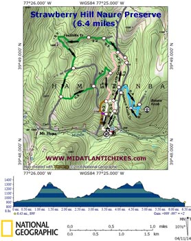
| Strawberry Hill Nature Preserve |
|
|
Description: Hans and Frances Froelicher began purchasing land in the Swamp Creek watershed in the 1960s primarily as a getaway from the urban hustle and bustle of their native Baltimore. After her husband�s death (1976) Frances created a foundation (1986) to help maintain the land as the Strawberry Hill Nature Preserve and Environmental Education Center. The 609 acres are open to the public to explore. Please follow all rules and consider making a donation or joining the effort. Google Maps Custom Driving Directions The hike begins across the road from the parking lot behind the pink cabin. |
|
________________________________________ |
Zipped National Geographic TOPO! GPS and Universal GPX Files |
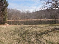
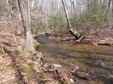
Trail Notes: Walk around the cabin. To the right will be a small pond. The white blazed nature Trail begins straight ahead through a towering stand of evergreens. The trail descends a couple of concrete steps and turns left onto an old road. You�ll catch nice views of Swamp Creek. In 0.3 miles from the cabin the trail crosses the creek on a bridge. Immediately to the left will be a section of the pink blazed Swamp Creek Trail. It is no longer maintained and, as such, is not shown on the Preserve�s map. It is still usable if you want to stay closer to the creek. Expect parts of the trail to be wet. Other wise continue on the white Nature trail. Either way you will arrive at another junction of the two trails and another bridge to the left in 0.2 miles. Continue to follow the Swamp Creek Trail for a similar distance. Turn right at a kiosk to follow the blue blazed Bakers Knob Trail. In a few steps cross a gravel service road and bare sharply left onto an old double track logging road. The trail climbs steeply for 0.6 miles. It forks at one point but the individual forks rejoin near the top just before a picnic bench and kiosk. You�ll pass a shortcut between the two should you decide to abort the climb. There is supposed to be a �leaf off� view from a rock outcrop about 200 yards south-east of the kiosk. I was harnessed to two Labrador Retrievers at the time so did not go looking for it.
Return to the Swamp Creek Trail and turn right onto it, enjoying the streamside views as you go. In 0.3 miles turn left onto that old service road you crossed while climbing the Bakers Knob Trail but only for a few steps before turning left off of it. Here you will rely mostly on the blazes as you cross a swampy area loaded with moss cover rocks and several rivulets. In 0.2 miles from leaving the road turn right for a few steps (the pink blazes will go to the left) and left onto the green blazed Foothills Trail. You will be on another old logging road but again just for a few steps before turning left into the swap again. Cross a fork of Swamp Creek and in 0.3 miles from joining the tree join another old logging road. In another 0.2 miles arrive at a 3X intersection with an access road. |
|
I think turning left onto it takes you to a private in-holding. Turn right instead, following the green blazes. The trail nearly loops back on itself before crossing a gravel road in 0.9 more miles. Take care as the trail will turn left onto an older logging road in 0.4 more miles and cross near an unnamed knob on the left before arriving at the same gravel road you crossed earlier. Cross it again. The trail veers sharply to the left. You might notice that most of the large trees are abnormally far from each other ( a result of �thinning�, a logging technique no longer used in PA) and that there is little in the way of understory (an indication of over-grazing by deer). The Preserve has planted numerous seedlings that need to be protected from deer with plastic tubes to help remedy the problem. In 0.4 miles the Foothills Trail ends at the pink blazed Swamp Creek Trail. Turn right onto it. In 0.5 miles this trail ends at a 4X intersection with the white blazed Nature Trail coming in from the left and proceeding straight ahead while the brown Quarry trail is on the right. Continue through the intersection onto the Nature trail. You�ll pass a shortcut to the quarry on the right in 0.2 miles. Continue straight on the Nature Trail arriving at the front of the pink cabin in another 0.3 miles.
________________________________________
________________________________________ |
|
|