|
Rockytop - Big Run Loop |
|
|
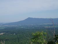
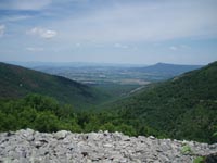
Description: This is a strenuous 13.8 mile Circuit over some of the most rugged terrain in Shenandoah National Park. If you are in extremely good condition and are contemplating doing this loop as a day hike choose a day during the summer when the days are long. Otherwise, consider doing it as an over-night backpack. The rewards are fantastic views of the Shenandoah Valley, the southern end of Massanutten Mt and the initial ridges of the Alleghenies as well as the beautiful Big Run on the return leg. There are several refreshing swimming holes along the trail.
Be prepared for steep, rocky terrain with frequent exposure to sun during the northernmost part of the ridge walk. Good footwear and sun protection are a must here. Much of the forest was destroyed in a huge fire in 1986 and it has yet to recover. There is no canopy along this section. The 1400 foot descent into the Big Run watershed is pretty steep (1400 feet in less than 2 miles) with sections of loose rock as the tread. The best camping near the mid-point is at the junction of the Big-Run - Portal Tr and the Brown Mt Tr. You'll find a couple of isolated sites along an unofficial trail right on the stream.
|
|
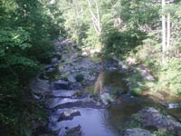
To add to the difficulty of the ridge walk there are 7 fords of Big Run and one of Rocky Mountain Run. Most of the time these may be rock hops but during/after periods of heavy precipitation they can easily become wades.
Save some energy for the end of the trek as you will have to climb 1500 feet over about 2 miles before returning to your car.
Special Note: Google Maps and other on-line mapping programs might suggest you use old fire roads that are no longer accessible by automobile. Use a real map to confirm your route. This trailhead is at the Brown's Gap Parking Area, 0.1 miles north of mile post 83 of Skyline Drive, on the west side. ________________________________________ |
|
Zipped National Geographic. TOPO! GPS and Universal GPX Files |
Trail Notes: All trail junctions are signed. All trails are blazed except the unofficial trail that leads to campsites near the mid-point of the hike.
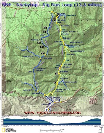
The northbound AT is in the back - right hand corner of the parking area. Follow the AT for 0.57 miles to the junction of the blue blazed Big Run Loop Tr. Turn left onto it. In another 0.67 miles come to a 4X trail intersection. Yellow blazed Madison Run Road Spur is to the left. The continuation of the Big Run Loop Tr (now blazed yellow for equestrian use) makes a sharp right here. You want to continue straight through the intersection onto blue blazed Rockytop Trail.
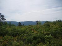
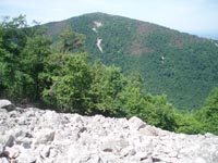
Pass the junction of blue blazed Austin Mountain Trail on the left in 0.42 miles from the last trail junction. In yet another 1.81 miles pass the junction of the blue blazed Lewis Peak Tr on the left. Up to this point the trail has been mostly flat or slightly uphill with a smooth or grassy tread and, for the most part, under a good canopy. For the next 3.5 miles or so the conditions change 180 degrees. The tread will become very rocky in parts with crossings through several talus rock formations, generally downhill and with frequent and prolonged exposure to the sun. This is where the views start.
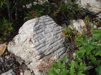
In 0.34 miles from the Lewis Peak Tr junction arrive at a large talus rock formation just off of the left side of the trail. This is "the back" of Rockytop. There is no view over the Big Run Drainage from here but you will find a westward view of the valley and Massanutten Mt bracketed nicely by Lewis peak to the south and an un-named peak (you'll walk around it in a bit.) to the north. This is a great lunch spot but be on the lookout for rattlesnakes and copperheads as they both frequent this and other talus slopes along the way.
After lunch continue north on the Rockytop Trail. Initially the trail follows the Lewis Run drainage at a lofty elevation, crossing a couple of large talus slopes. |
|
Lewis peak will constantly be in site until you veer away from the drainage and climb via some short switchbacks and travel along the northern slope of the previously un-named peak. Almost endless views will continue for the next mile. Some of the trail is terribly overgrown here but it is still easy to follow. As mentioned in the description, the last 2 miles of the ridge walk is a rapid 1400 foot descent over some pretty loose rocks. There are a couple of switchbacks but they are of little help.
At the bottom of the descent turn right onto an old jeep road. This is yellow blazed Big Run - Portal Trail. The first 0.1 miles is on private property but you are within park boundaries soon enough. Descend on the road for 0.47 miles and cross Big Run on a well constructed metal bridge. If you wish to camp for the night turn left and follow the trail to a signpost at the northern terminus of the Brown Mountain Trail. To the left is an un-marked but obvious footpath. Follow it for about 100 yards to a campsite with wading pool on the left. There is yet another one about 100 feet further down the trail. If these are taken continue upstream on the Big Run - Portal Trail. There are some small, hidden campsites off of the trail about 500 yards up from the bridge.
To continue the hike hike upstream on yellow blazed Big Run - Portal Trail. The first ford is about 0.27 miles from the bridge. Cross 3 more fords in another 0.47, 0.36 and 0.18 miles. I'm particularly fond of the swimming hole just above the last one. In 0.12 miles the trail splits with blue blazed Rocky Mountain Run Tr going to the left. Stay straight on the Big Run - Portal trail and soon ford Rocky Mountain Run. Just above this yellow blazed Patterson Ridge Trail comes in from the left. Stay straight on Big Run - Portal Trail.
Three more fords occur at 0.73, 0.24 and 0.19 mile intervals above Patterson Ridge Tr. In another 0.28 miles, to the left, is the best campsite in the area. It is on a bench paralleling the run under some still living Hemlocks. It wasn't mentioned as a potential campsite earlier because it is considerably beyond the mid-point of the hike. If you had the fortitude to continue on after reaching the drainage then this is your place. In another 0.68 miles you'll pass the last campsite along the trail. It is a flat area to the right of the trail. It is overgrown but has some pretty nice flat ground nonetheless. A hundred yards or so beyond that arrive at the junction of the Big Run Loop Trail. Turn right here (Yellow blazed) and climb steadily for 1.2 miles to a 4X trail junction. You walked through it at the beginning of the hike. Turn left onto the continuation of the Big Run Loop Trail (Now blazed blue.) and follow it to the AT. Turn right onto the AT and follow it back to your cars.
Printable/Downloadable Trail Notes ________________________________________ More Photos
________________________________________
Name: Hikermel Outing Critique: A beautiful August day in Virginia, hot, but not as hot as it could have been. We were three women in our 50s, experienced and avid hikers. Still, I was a little nervous when I had a hard time finding anyone writing of doing the trail in a day! We set out from Brown Gap at 9:44 am returned at 3:41 pm. So six hours altogether including half an hour for lunch under the bridge on the lower portion of Big Run Portal Trail. Overall it was an awesome hike! Rocky Top trail was quite overgrown with weeds and seedling trees, and the water bars had suffered much damage from bears. We did see one young bear on Big Run Portal Trail. I would definitely do this loop again as a day hike. We found it to be easier than Three Ridges (AT- Mar Har Trail starting at Reed's Gap) which is about the same distance. ________________________________________
Name: Tom
Outing
Critique:Beautiful area of SNP, among the best in the
park. Relatively underused trails; during the three day
weekend I saw seven people. ________________________________________
Name: John Yancey Hike: Rocky Top-Big Run Date(s): 10/03-05/14 Rating: 3.7
Critique:
I just finished hiking the Rocky Top/Big Run loop with another
father and our 11 year old sons and let me start by saying it
was a great trip. Your map and trail notes were spot on and
very helpful. I printed the map and notes and gave them to the
boys and let them guide us along the trip. It improved their
map reading skills and gave them a sense of where we were and
where we needed to go throughout the trip. We made the trip a
three day/two night back country experience. We camped the
first night at the bottom of the Rocky Top ridge at the junction
where it meets the Big Run loop at the campsite you listed to
the left after the steel bridge. It was one of the best
campsites I have used in a very long time. ________________________________________
Name: Dan M. Hike: Rocky Top-Big Run Date(s): 04/05-06/14 Rating: 5
Critique: I have spent a lot of time in SNP, and this by far has to be my favorite hike. I did this in early April as an overnight with my girlfriend. This hike has everything that SNP has to offer. Great views of the valley and rolling mountains. Talus slope crossings. Great wildlife. Stream crossings and a nice walk along a beautiful stream. The trail directions were spot on except THE LAST TWO MENTIONED CAMPSITES ARE NOT THERE. The last two campsites have no camping signs posted in them. I assume they were over used and the park wants to rehab the nature in that area. So if you do this as an overnight and do not want to stop 7 miles in. Make sure you understand there are no official camp sites on the hike. The other thing that I feel the writer left out is you will not come to an area where you can refill your water until the first set of campsites (midpoint Approx. 7 miles in). I did this in April so I was okay with the water I brought. But in the summer, if you don't have enough water this could be tough. You are exposed for a large part of the beginning of this hike if done as the writer dictates the directions. This is a MUST DO hike in SNP. Enjoy! ________________________________________ Name: Janet Emily Hike: Rocky Top/Big Run Loop Date(s): 08/07-09/13 Rating: 4
Critique: First - thank you so much for this site. It is the most helpful planning site I have found for any area of the US. We followed the route as outlined in the description, but made it two overnights so we could spend more time in the area. For the ridge section, I would add that the nice lunch stop appeared to be the only nice lunch stop. I mistakenly thought I would find another spot farther on, but eventually we hunkered down in some shade right on the trail. The campsites near the bridge were wonderful and we loved the wading pool. The water was warm enough for a refreshing bath. On Day 2 we took a side hike up Brown Mountain Trail. This is roughly 1000 feet over 1 mile so we left our packs at the camp site. There are no pre-made viewpoints, but at the .9 mile mark you'll see a fairly open area that you can climb up and perch on a rock outcrop for a wonderful view. We failed to discover the "best camp site" mentioned. We found one site that could have matched the description, but did not match the GPS distance. The site offered room for 3 tents and was wide, under some hemlocks. But the creek access along the full length of the site was guarded by lush stinging nettles. I found one path through them to collect water. Also, this site was completely hidden from the trail. You have to look for it to find the faint manpath to it. We liked the first campsite better. Also, the last campsite on the trail, just short of the connector to Big Run Loop trail, is bare minimum. It is on the creek side, but there is no water access. On the other side of the trail the site is marked "No Camping". Maybe the "best camp site" was one of these marked "No camping". We were glad we went back to find the "best camp site" and found a good one. We saw a school of Brown Trout, maybe 50 fish, in a pool 1/4 mile prior to our second camp site. Right after a ford. My husband caught 4 trout in a hurry, but they were not quite big enough to eat. It was August. We walked out the final 3 miles the next morning and loved the climb out. Just beautiful, and we were fresh enough to enjoy it.
________________________________________
Name: Melissa
Hike: Rockytop-Big Run Loop ________________________________________
Name:
Blackmamba549
Hike: Rocky top-Big Run ________________________________________
Name: Jason
Hike: Rocky Top-Big Run Loop ________________________________________
name:
WoodbridgeVa
Hike: Rocky Top - Big Run Loop ________________________________________
Name: Bryan
Hike: Rocky Top/Big Run Loop ________________________________________
Name: The Tick
Hike: Rockytop- Big Run Loop ________________________________________ |
|
|