|
Old Logger's Path |
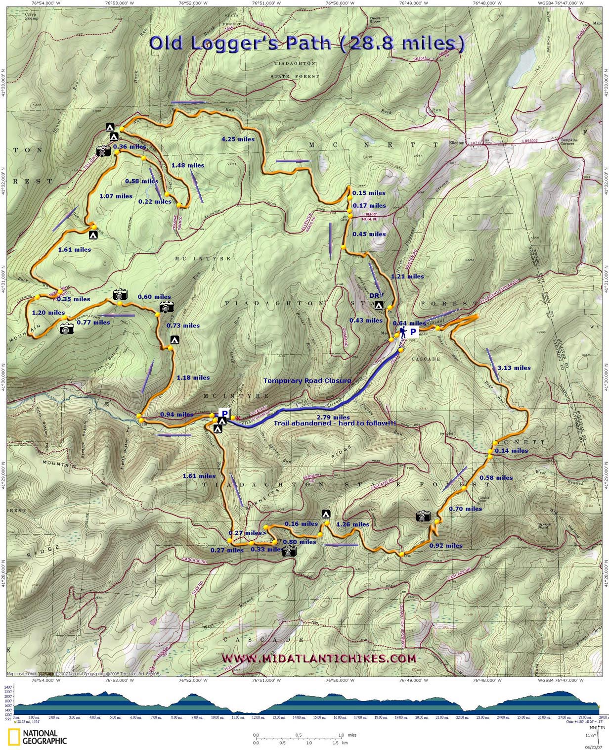
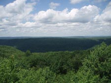
| Description: The Old Logger's Path is quickly becoming one of the most popular backpacking venues in the Keystone State. This 28.8 mile long (Some references, including the State Forest map, has the distance at 27.3 miles.) Is composed mostly of old logging railroad grades and haul roads interconnected by strategically placed foot trails. It's official start and end is at the old ghost town of Masten. If you use that as a location you can use any of the on-line mapware programs to get you there. The highlights of the loop are the many vistas, Pleasant Stream, Yellow Dog Run and, most of all, Rock Run and the gorge it has carved through the rocks through the millenniums. There are campsites at most stream crossings but the best are along Pleasant Run and at the confluence of Yellow Dog Run and Rock Run. If you don't have the time to do the entire thing or just want something shorter use the old railroad grade that connects the east and west sections as a cross-connector. The northern loop is about 21 miles long. The southern loop is about 13 miles in length. Note: This connector can become overgrown in the summer and difficult to follow. |
|
Note: The trailhead is at the large brown and white sign at the site of the old logging town. Travel Note: As of the above revision date a 3 mile portion of Pleasant Stream Road is temporarily closed for repair. If approaching the trailhead from the west one has the option of parking just before the barricades near Short Run and walking back on the road a few yards to pick up the OLP on the south side of the road. If hiking clockwise you will be about 11.5 miles south of the Rock Run Campsite. There is another campsite on Doe Run if you want a shorter first day. ________________________________________ |
|
(Sized for 11X17 stock) Zipped National Geographic. TOPO! GPS and Universal GPX Files |
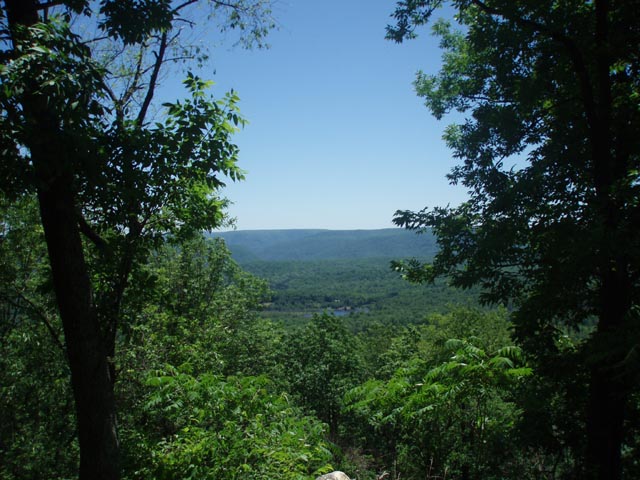
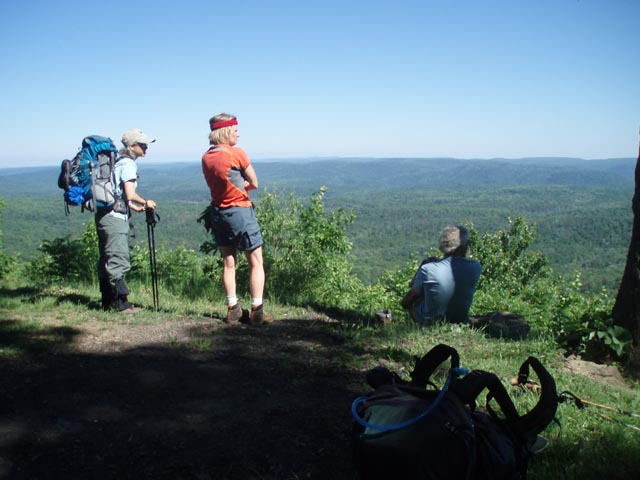
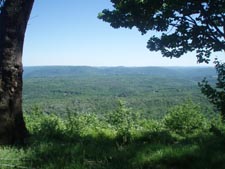
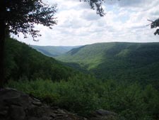
Trail Notes: The entire trail is blazed orange with arrows noting change of directions. Watch out for these as the route constantly jumps from one grade to another and it's easy to walk by a footpath with obvious blazes if you are , shall we say, engaged in conversation or perhaps letting your mind wonder. It's easy to do here. Believe me. From the trailhead proceed east on Pleasant Stream Road. Cross the stream on a bridge. In 0.64 miles from the beginning turn right off of the road onto a footpath. Climb steeply for a short distance to the first of many railroad grades. Turn left onto the grade, traveling east still. In about 0.5 miles you'll turn right and climb to yet another grade. Turn right again, traveling west. The grade will slowly climb and curve around the mountain in a more south-easterly direction. Descend and cross an old woods road at 3.13 miles from first joining the grades at Pleasant Stream Road. In another 0.14 miles cross a gravel road, jogging to the left a bit and proceeding down a driveway. Almost immediately the trail leaves the driveway to the right. Watch for the blazes. In 0.58 miles descend to the spur trail on the left for the Sproul Point vista. After checking out the views continue your descent crossing gravel Cascade Road in 0.92 miles after the vista. In another 1.28 miles the trail will cross a stream and bear left onto another railroad grade. There is a nice campsite here. Shortly after turning onto this grade turn right onto a footpath and begin a steady, long climb. In 0.8 miles reach another grade. Turn left onto it and follow it out to John Merrell Road and Sharp Point Vista. After taking in the views here proceed west on the road leaving it to the left in about 0.33 miles. Descend on a narrow piece of sidehill trail. The footing is tricky here and the slope to your left is very steep. In 0.27 miles cross the road and pick up another railroad grade. In 1.61 miles arrive at Pleasant Stream. There is a nice campsite before the ford and more on the other side. This is a good place to call it night. |
|
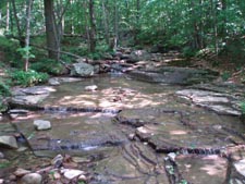
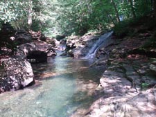
After successfully crossing the stream find a campsite to the right. There is also a spur trail which I think leads to more sites. In a short distance climb up to another railroad grade. Going right will take you back to your car. Turn left here if completing the entire circuit. In 0.94 miles turn right off of the grade and arrive at Pleasant Stream Road. Turn left on the road, cross Long Run on a bridge and immediately turn right onto the continuation of the trail. Here the trail picks up another grade and follows it up Long Run. The trail will leave the grade, as you descend to the run and climb up to the other side to another grade. The trail is blazed in both directions for some reason. Turn left here continuing upstream. In 1.18 miles from Pleasant Stream Road the grade meets the run. There is a small campsite here on and island. Cross the stream and turn downstream for just a few steps towards the camp to pick up the continuation of the trail on the other side. The trail continues upstream from here and soon comes to a large fern clearing. Turn left onto a footpath and climb steeply for 0.73 miles to the first of many vistas on Sullivan Mountain. This one isn't obvious. You have to slide between some mountain laurel to get to it. In another 0.61 miles there is an even grander vista and yet another in another 0.77 miles. In between there are other "partial" views. In 1.2 miles from the last vista turn right onto gravel Ellenton Road. Follow it for 0.33 miles and turn left onto another trail. Follow a railroad grade for 1.61 miles to a nice campsite on Doe Run. Shortly after passing the camp the trail crosses the run and follows its northern bank westward for a while before turning northeast again. In 1.07 miles from Doe Run come to a blue blazed spur trail on the left. Follow it for a tremendous view of the Rock Run Drainage. Continue on the Old Logger Path. In 0.36 miles cross a gas line swath.. After this crossing the trail descends for 0.58 miles to yellow Dog Road. Bear right onto the road and follow it for 0.22 miles. Turn left onto a footpath that runs into another grade. Follow it for 1.48 miles to the confluence of Yellow Dog Run and Rock Run. There is a large campsite here but even more places for tents on the other side of Yellow Run. This has got to be one of the best places to camp in all of PA. Enjoy the falls, chutes, swimming holes and water-sculpted rocks. The initial part of the grade appears to be constantly wet from a seep coming down from the hill. This only lasts for about 30 yards. Rock Run is very scenic but the trail leaves the streamside grade way too early. You might want to bushwhack further up the stream to visit some of what few have take the time to see. Climb steeply up a footpath to join another grade that is higher up the mountain. Eventually the trail will assume a very slight upward pitch but the climb up to it can be a bit challenging. In 4.25 miles from camp the trail will come out to what appears to be a frequently used logging road. Turn right onto it. In 0.15 miles turn left onto a footpath. Follow this a short distance to once again join Ellenton Road. Turn left here but when the road splits turn right onto another road. This is part of blue blazed Cherry Ridge Trail and is signed as such. Follow the road for 0.45 miles and turn left onto a footpath that quickly joins another railroad grade. In 1.21 miles arrive at a nice but dry campsite. Shortly after this the trail crosses a seasonal stream and in 0.43 miles arrives at Pleasant Stream Road once again. Turn left here and in a few yards arrive back at your car. Printable/Downloadable Trail Notes ________________________________________
________________________________________
Name: k8tlevy Hike: Old Loggers Path Date(s): 08/30-31/14 Rating: 4
Critique: We
did this as a two day fast and light backpacking trip over Labor
Day Weekend - loved it, even though it rained like crazy one of
the days! Didn't see the road to Masten was out until we tried
to drive in on it Friday night. Luckily, the detour was easy to
follow. ________________________________________
Date: 05/24/14 Rating: 5
Critique: We did this as a 3 day backpack over the Memorial Day Weekend, really enjoyed it, great views and streams, weather was mostly great except for a brief thunderstorm the first night. Pleasant Stream Road is passable IF and only IF you have AWD and decent ground clearance, our vehicle was a Toyota RAV 4 and we talked with another group who drove a Subaru Outback along the road, should not be attempted in a normal road car as there is a short "home made" detour where the creek washed the road out, it's only about 30 yards long but is very rough, with rocks and deep pot holes which would ground a road car, we scraped once but made it through. Plenty of water along the trail, mostly in good shape but some blow downs to get around/over/under. The beginning at Masten is a little confusing because it's hard to tell what direction you're going, we initally thought we were doing the loop clockwise, turned out we were going counter-clockwise, doesn't really matter that much but it would be nice if DCNR could put up a sign giving an indication of which way to go for each direction around the loop. There are also many more campsites than are listed on the map, although some don't have water. ________________________________________
Name: Chris R. Hike: Old Loggers Path Date(s): 04/12 to 13/14 Rating: 3
Critique: THE BRIDGE AT MASTEN HAS NOW BEEN REPAIRED. I wanted to inform hikers that the bridge is rebuilt. Pleasant stream road is still closed to traffic from around Masten for about 3 miles west to about Short run. According to the ranger at Hillsgrove, it is open for hikers to make a loop out of the southern or northern loop, but is undrivable. The road is now in the process of being repaired as well. Attached is a picture of the bridge if needed. Heading counterclockwise from Masten, there is a nice break spot at a campsite off to the right of the trail about a mile or so before the intersection of Rock Run and Yellow dog run. We discovered a seeping water fall below the small cliff below the campsite which was a pleasant surprise. After teaming up with a group of 6 guys from south Jersey we headed out to Rock Run for a one night loop hike. Due to time we made a small loop using Old Loggers Path clockwise from Masten to Rock Run/Yellow dog run. Then returned to Masten via Old loggers Path to Ellenton Road, to Short Run trail, Cherry Ridge trail back to Old Loggers path. It took about 3 1/2 hours to hike back from Rock Run campsite. Note: If you plan on arriving late into Masten contact the Hillsgrove Ranger Station off of Rt. 87 to get a camping permit in the C.C.C camp prior to getting going the next morning.
________________________________________
Name: Ryan Hike: Old loggers Path Date(s): 09/13/13 Rating: 4
Critique: We did
the upper loop and cut across Pleasant Stream Road (21.5 miles). Very
well maintained trail, blazes were freshly painted and someone very
recent was doing trail work since most of the brush was freshly cut with
shears. All the inclines are quite gradual and the vista's are quite
nice. We ended up camping at popular swimming hole. The water carves out
great swimming holes and the camp sites were quite large. The weather
was cooler this weekend and jumping in the water was not an option, but
would really like to check this out next summer for. Overall a nice
trail and had limited traffic. Our GPX can be downloaded from here.
http://www.trimbleoutdoors.
________________________________________
Name: Sam Hike: Old Loggers Path Date: 07/05-07/13 Rating: 4
Critique: Hard Core, Wooly Bully, Ted E. Bear and Shortstack did the OLP in the heat, thunder (but no rain during the day) weekend. We first stopped at the Forest Ranger Station at Hillgrove, PA to get information regarding parking at Masten Road, since the websites indicated the bridge was out and possible road closures. We parked at the campsite along Masten Road as directed by the Forest Service. There is parking just past campsite E, where the Forest Service mowed a small field for OLP backpackers/hikers� parking. Although the Park Service directed us to this parking area, we did not think to ask, and they did not advise us, how to get to the trailhead since the bridge across Pleasant Stream is gone and a new one is under construction (see photo). We planned to do the loop clockwise and wanted to cross the river to get to the trailhead using M.R. Hyker�s https://www.midatlantichikes.com/oldloggerspath.htm website. We lost an hour between forging the wide and fast running stream at the construction area and trying to find the trailhead. After we crossed and got on the road, we saw a roadway we might have used if we walked further up the road past the bridge construction. However, it appears to be private property, so we hesitated. Note to future hikers/bpers: ask the Forest Service if you can use the nearby driveway at Masten that crosses Pleasant Stream to get to the trailhead. The rest of the first day 12-mile trail was easy and well marked. We camped along Pleasant Stream at a large, beautiful campsite. Day 2 was another 12-miler. Although we had all day to do it, it took us considerable time due to crossing Pleasant Stream again, the heat and some hills. In addition, we lost the blazes at one of the scenic overlooks. Wooly Bully looked downed to admire the view and was about to climb down the rock outcrop when we saw two rattlesnakes on the rocks below. Beware! At that location, we lost the blazes and could not find the trail. This happened again at other locations along the vistas and beyond due to overgrown vegetation. Despite the trail conditions here, we got to the Rock Run and Yellow Dog Run campsite by late afternoon - enough time to cool off at the swimming holes. We had the campsite to ourselves but apparently, it is very popular with day-trippers on the weekends as there were many family groups hiking back up to the road as we descended to the run. Day 3 was a relatively easy 7.6-mile trek back to our car with a few spots that M.R. Hyker refers to, as �climb steeply�might be a bit challenging.� Fortunately, they were short. The OLP is a nice 3-day backpack. The trail was very wet and muddy in many places so we appreciated the warm weather. We logged 31.9 miles according to the GPS due to the first and second day trail mishaps.
________________________________________
Name: Big Mo
Hike: Old loggers path
________________________________________
Name: Greg Romano
Hike: Old Loggers Path ________________________________________
Name: Ed Duguid
Hike: Old Loggers Path ________________________________________
Name: Tom Tulenko
Hike: Old Loggers Path ________________________________________
Name: Bob Handelsman
Hike: Old Loggers Path
________________________________________
Name: Tim C
Hike: Old Loggers Path ________________________________________
Name: Big Dog David
Hike: Old Loggers Path-13 Mile Loop ________________________________________
Name: John
Hike: Old Loggers Path ________________________________________
Name: Steve
(hikingff77)
Hike: Old Loggers Path ________________________________________
Name: paknees
Hike: Old Loggers Path ________________________________________
Name: MDRaven
Hike: Old Logger's Path ________________________________________
Name: Bob
Hike: Old Logger's Path ________________________________________
Name: Kyle Henson
Hike: Old Loggers Path - North Section ________________________________________
Name: T Mainzer
Hike:
Old Loggers Path ________________________________________ |
|
|