| Mid State Trail Backpack Shuttle - Blackwell to Little Pine State Park |
|
|
Description:
The Mid State Trail is a 313 mile trail that when complete (325
miles) will extend from the New York state border to Maryland at
Green Ridge State Forest. Described here is a 26 mile shuttle
backpack from the original northern terminus in Blackwell to
Little Pine SP. It is considered by many to be the most remote
section of the trail, passing through Tiadaghton State Forest,
two parcels of SGL 75, Wolf Run Wild Area and Cabin Run Natural
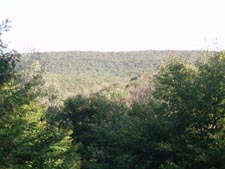
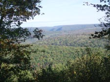
Area. You�ll pass three vistas , including
the
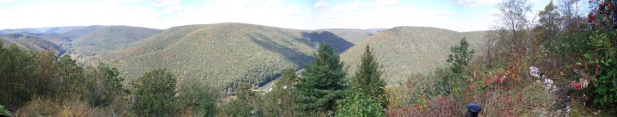
180 degree view of Gillespie Point overlooking Pine Creek
Valley, the beginning of the Grand Canyon and Babb Creek Valley.
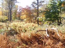
The treadway is a combination of footpaths, old grades and
grassy maintenance roads/trails that pass through hardwood
forests and wonderful Eastern Hemlock groves.
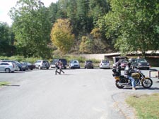
Leave a vehicle at the overnight parking area at Little Pine SP campground. Be sure to register at the admission station. The hike starts at the canoe access parking area on Rt414 just before the large bridge over Pine Creek. The following Google Maps shows the shuttle: Google Maps Custom Driving Directions
The Mid State Trail is part of the Great Eastern Trail (GET). |
|
________________________________________ |
GPS Text File for Non-TOPO! Users
GPS Text File for Non-TOPO! Users
GPS Text File for Non-TOPO! Users Zipped National Geographic TOPO! GPS and Universal GPX Files |
Trail Notes: The MST is blazed with orange paint rectangles and usually well signed.
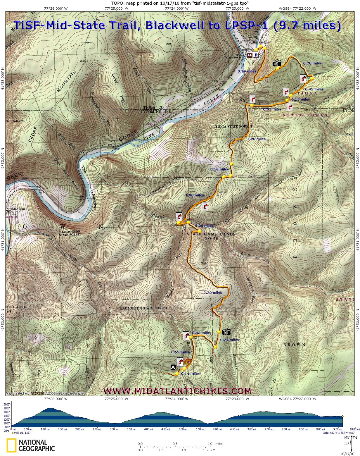
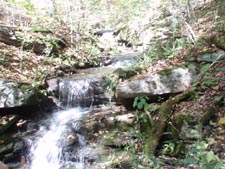
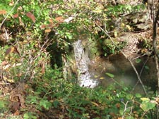
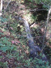
Day 1 (10 miles and 2400 feet E.G.): From the parking area turn right onto Rt414. Cross Babb Creek on an open grate bridge. Turn right onto gravel Big Run Road. As the road bears to the right bear to the left onto a footpath and climb steadily for 0.99 miles to Gillespie Point. This is a good place to take a break and reward yourself with the 180 degree view. The initial descent to Brill run is pretty steep but soon moderates as it reaches to bottoms. As you descend you will cross a logging road. In 0.78 miles from the vista cross the stream and turn right onto an old railroad grade and follow it for 0.43 miles to Big Run Road. Cross the road, jogging to the left a little to pick up the trail again. Cross Brill Run at it�s confluence with Big Run and then Big Run itself. After the crossing bear right onto another old logging grade and follow it for 0.61 miles to a small campsite overlooking the run in a rocky ravine. Cross a small tributary on a narrow bridge. Here the trail climbs to the left a bit to join yet another grade that parallels the tributary for 1.28 miles. Cross a dirt road. In 0.10 miles enter SGL 75 (NO CAMPIMG), turn right onto a grassy maintenance road but in just a few steps turn left onto a footpath and descend along a tributary of Trout Run passing two 10 foot waterfalls before it drains into the run. 1.00 miles after the grassy maintenance road. the trail switchbacks to the left off of the grade to Trout Run. Cross the run and bear left, climbing slightly to an old road in .10 miles. Turn left on the road, cross Brown Fork at a vehicle ford and pass another road on the right. Almost immediately turn right onto a footpath and climb to a grassy management road in 0.20 more miles. Turn right onto it and ascend gradually, passing a vista at 2.20 miles from the last turn. Watch carefully for blazes on the right and turn onto a footpath in another 0.24 miles. Follow a shallow draw and part-time stream for 0.43 miles to a turn around area. Bear left onto double track Brown Fork Road and follow it for 0.52 miles to a driveway on the right. Follow the driveway, passing a hunter�s cabin and crossing streams on 2 narrow bridges. Here you will find a dense copse of Hemlocks and your home for the night.
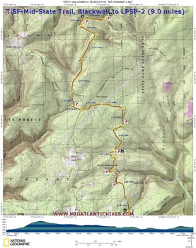
Day 2 (9 miles and 1400 feet E.G.): Continue to follow the orange blazes above a stream. At 0.53 miles pass a potential campsite on a bench on the other side of the stream. In another 0.28 miles the trail will make an abrupt left turn to climb steeply out of the drainage. Reach the top and a nice window-sized vista in another 0.55 miles. From here the trail descends gradually for 0.92 miles. Turn left onto yet another grassy maintenance road (There will be a large wildlife clearing to the right.) and follow it for another 0.92 miles. Cross Barrens Road and enter Wolf Run Wild area. Cross the headwaters of Sebring Branch in another 0.42 miles and in 0.24 miles cross Silver Spring Road. Cross a power line swath in 0.64 miles. In another 0.55 miles the trail will make a 90 degree right turn to follow the boundary of SGL 75 (NO CAMPING.) marked by white blazes and heavily posted. There is one small campsite just outside the boundary. This continues for 0.47 miles before turning right and descending to Silver Branch in another 1.00 miles. This is a vey large group campsite nestled under a canopy of Hemlock. Shortly after the campsite re-enter SGL 75. In 0.31 miles turn right for a short distance onto a maintenance road and then right to continue on. The next 1.68 miles is perhaps the most sublime part of the hike as you walk an old railroad grade above pretty streams and crossing the likes of Bark Cabin and Bennys Runs, the entire time under a canopy of Hemlock. Cross a power line swath and enter Cabin Run Natural Area (NO CAMPING). In 0.47 more miles leave the natural area and cross Ott Fork. You are now on legally �campable� ground. As the trail turns right to begin a climb watch for a bench along the stream protected by a stand of White Pine to your right. This is your home for the night. There�s nothing quite like several inches of pine straw to set your tent up on and a gurgling stream to put you to sleep!
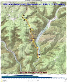
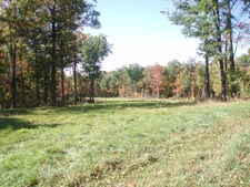
Day 3 (6.42 miles, 700 feet E.G.): After a hardy breakfast climb gradually out of the Ott Fork drainage and in 0.69 miles cross Hackett Road. Descend quickly to Hackett Fork and cross the stream near a very small campsite. The trail continues to follow another fork for 0.81 miles, crossing it several times near the top. In 0.81 miles from the small campsite cross Schoolhouse Road. In 0.53 miles the yellow blazed Panther Run Trail comes in sharply from the left. There is a partial view of Little Pine lake here. Continue straight as you follow dual blazes for the next 1.27 miles. There will be a couple short but very steep descents before arriving at the junction of an old quarry road. Drop your packs here and continue straight to an old quarry site with views of the surrounding hills. Return to the quarry road and follow it for 0.30 miles as it descends to Love Run Road. Turn left and arrive at a hunter�s cottage in 0.46 miles. The continuation of the MST is behind the cottage and requires a very steep climb up the Pesto trail. Since I had already hiked it (See the MST-Little Pine SP Loop elsewhere on this site for info if you are a purist.) and we had already hiked 5 miles in a fairly heavy rain we continued for 0.97 miles on Love Run Road as the stream of the same name babbled to our right. Once you arrive at Little Pine Road cross it, turn right and follow the shoulder for 1.10 miles back to the campground where you left your vehicle. There is a pretty picturesque view of Little Pine Lake and the valley around it as you crest the hill. It�s worth a short visit.
|
|
________________________________________
________________________________________
Name: Ben
Hike: mid state trail - Blackwell to Little Pine ________________________________________ |
|
|