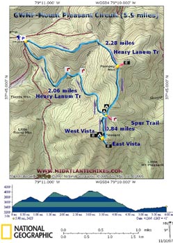
Mount Pleasant Circuit

Description: This is a fantastic 5.9 mile moderate circuit and one of the favorites of local hikers. The 1200 feet of elevation gain 
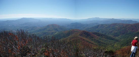
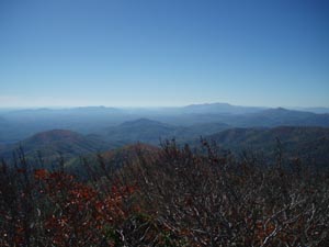
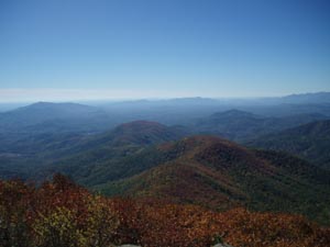
rewards the hiker with some of the best views in GWNF! It's a shame it is so short. We highly recommend combining this one with the Cold Mountain Loop to form a more rigorous, yet even more rewarding, 12 mile day hike or perhaps even a backpacking trip. If the skies are clear it will be one of the most memorable trips in the region, guaranteed.

Google Custom Directions

The trailhead parking area is off of Wiggins Spring Road (FR 48) just beyond the AT parking area. It is signed.

________________________________________


Printable/Downloadable Map

View 3-D Map

Zipped National Geographic. TOPO! GPS and Universal GPX Files

GPS Text File for Non-TOPO! Users


Trail Notes: Since the Henry Lanum Memorial Trail is a loop it has two trailheads. Either one will get you to where you want to go. This description has you taking the left one to Pompey Mt first, doing the loop in a clockwise direction. All trails are signed and blazed with blue paint.


From the trailhead pass through a horse gate and start a gradual climb on an old woods road. In o.68 miles you will reach the top of a false summit and descend into a low spot on the mountain. Again begin a gradual ascent. The final climb to the top of Pompey Mountain (0.45 miles from the low point) is steep and rocky but, fortunately, it is also short lived. At the top look for an unofficial trail on the left that leads to a minor vista. We missed it but others have told me that it is there.


In another 0.68 miles you will reach the junction of the two parts of the Henry Lanum Memorial Trail and the Mount Pleasant Spur Trail. Just prior to this  is a large area suitable for several tents. You will also pass a signed spur  trail on the left that leads to a seasonal spring. Begin a steep, rocky ascent. Pay attention! at one point the old Summit trail continues straight ahead  while the blazed trail switchbacks sharply to the left. Follow the switchback. In about 0.6 miles from the last junction the trail splits. Going left will take you across flat rocks to the East Vista. Going right takes you to the West Vista and requires a bit more effort ending in a scramble up a large rock outcrop. The extra effort is paid back with a 270 degree view.


Return to the Henry Lanum Memorial Trail and take the left fork. The initial descent will be steep and rocky. Keep an eye out as a trail comes in from the left. This is an old section of trail that is no longer used. It will rejoin the trail again as the real trail joins a woods road at a sign. Follow the blazes straight ahead. From here it is a very gentle 1.2 mile climb back to the trailhead parking area.


Critique This Outing

________________________________________

________________________________________

Name: Scott_R                                                                                                           Hike: Mt. Pleasant
Date: 12/18/11                                                                                                         Rating: 5

Critique: This is quite close to home and I can't believe I've never gone before!

As described, the terrain was moderate; we are both avid hikers and in good shape, so we didn't find the climbs difficult at all. We did the whole loop in about two and a half hours. The trail notes and suggested loop rotation seemed ideal to us. Going counter clockwise would have involved a pretty steady long climb up to the peak, and is not advised unless you specifically want a workout.

The road in was well marked, all the way from US-60, and we had no difficulty finding the trailhead.

Views were just fabulous - completely worth it. The two vistas from the Mt. Pleasant peak were phenomenal. Campsites were as advertised and there were signs for water sources which were pretty handy if you're camping. We'll be going back when the weather warms up a bit for just that. This was just a fantastic gem!

________________________________________

Name: Leslie Ann Jones, DVM                                                                                 Hike: Mount Pleasant
Date: 10/4/08                                                                                                            Rating: 4

Critique: Wonderful, but a bit challenging. We really enjoyed the Mount Pleasant 6+ mile loop, however, we found out the hard way that the road from 60 that should take us up to the trail head (North Fork Road- VA Rte 635) has been washed out about 4 miles up. That left us to hike in an additional 2.5 miles to just get to the trail head! Now that we've done some serious Google-Earthing of the region and the topography, I think we have figured out how to get to the trail head off Wiggins Road, but DON'T try to get to the trail head from North Fork Road, as what should have been about a 3-4 hr hike was the bulk of 6 hrs and we almost got lost after dark! yikes!

Looking forward to trying some more of these hikes soon, but need to recover from Saturday first!

________________________________________

Name: John S                                                                                                              Hike: Mt. Pleasant Loop
Date: 9/27-9/28/08                                                                                                 Rating: 5+

Critique: An absolutely fantastic, excellent hike. I think Mt. Pleasant might have the best vistas of any hike I've done to date. I believe it blows other hikes I've done, i.e. Gregory Bald and Mt. Cammerer (in the Smokies), out of the water, and it's a much easier, more rewarding hike. I'd highly suggest this hike for those fellow backpackers who find it impossible to get a significant other to tag along or find it hard to find a nice hike because of their dogs; it's not terribly difficult (but no spring chicken) and it's incredibly rewarding. Hike this one as suggested - starting towards Pompey mountain first. Once you head down Mt. Pleasant, you'll understand why - the trail is pretty demanding in the opposite direction.

I would highly suggest that anyone wishing to do this hike consider doing it as an overnight. It is short, but there are at least four EXCELLENT campsites at the summit of Mt. Pleasant. The trail summary here and on hikingupward.com make it seem as if there is only one campsite at the summit, but there are indeed four! Some reviews have said that the campsite along the sister hike to Mt. Pleasant, Cold Mountain, is the best site in GWNF, but I think I disagree. We stayed at an awesome site just below the east vista. There were two sites near the west vista and two near the east vista. All sites had their own fire pit, and enough room for a 2/3 person tent + fly.

When the weather finally cooperated, the vistas were amazing. The west vista is slightly better, but the sunrise can only be seen from the east vista, and it was fantastic. Make sure to see all of the west vista, as there are a couple extra trails in the area to other rock vistas. The east vista is about 180� and the west vista is about 270�. There is plenty of room at both vistas for people and animals - it is impossible to hog these vistas (contrary to the other review) so don't worry about this. The only better vista I can remember better than this one might be atop Flat Top at the Peaks of Otter (and only because it is 360�). Again, I can't express the beauty of the vistas, they were fantastic. I am a backpacker/hiker that enjoys mountain hikes to good vistas, and this one is the cream of the crop!

________________________________________

Name: Galen                                                                                                                Hike: Mt. Pleasant loop
Date: 2-9-08                                                                                                                Rating: 2.5

Critique: Did this one on an abnormally nice February day. Drove 3+ hours to get out of my normal hiking area. (closer to DC) After seeing the photos and hearing about how great it is, I was looking forward to this one.

We accidentally started off going counter-clockwise on the Lanum trail, which was really confusing. It was fine though, it all goes to the same place and is a well-maintained trail. Definitely not too tough on the legs but it's no walk in the park. The climb up to Mt. Pleasant is a little rougher and has some neat vegetation changes on the switchbacks. The west vista is really nice. I can't imagine you'd get a much better view from anywhere else. And the campsites at the top must be the best around, just steps away from the summit view. Never got to see the east vista because someone was hogging the rocks with their UNLEASHED dogs. (I have two dogs on leashes.) Heading back along Pompey Mountain and back to the car, there's not much to see. The terrain is your standard tree-shrouded mountain with a few tiny streams here and there. It's a fine walk in the woods but I wouldn't call it a classic.

NOTE: Thanks to the trail maintenance folks who were doing their thing that day. We appreciate your work. Also, I have to say that the road to the trailhead can get a little rough for some cars.

________________________________________


VA Hikes MD Hikes WV Hikes PA Hikes Contact Us Home