|
Morgan Run Loop |
|
Description:
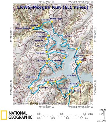
The Morgan Run Loop is an easy to moderate 8 mile circuit around
the upper reaches of the west branch of Liberty Reservoir. The
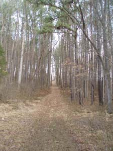
tread is composed of wide fire roads over rolling terrain. Any
steep hills are of short duration. The east side of the hike
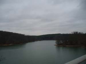
offers several
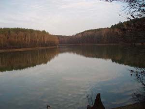
nice views of the lake. The northern end features a nice
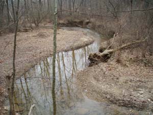
walk along pretty Morgan Run and a tempting looking
swimming hole created by an over-zealous beaver. For the
most part, the western leg stays away from the lake except in
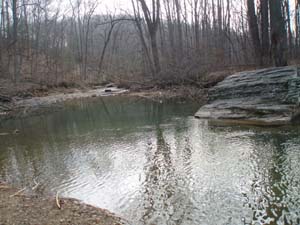
two places where it literally "kisses" the bank. Along this
stretch you will encounter two
stream crossings which are usually rock hops or shallow
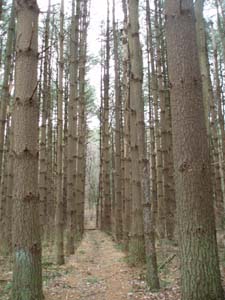
fords. As with most reservoir hikes you'll spend a lot of time hiking along the edges of or through giant pine groves with deciduous forest in between. The only down sides are a brief walk along a power line swath and the crossing of the Rt 32 bridge at the end of the trek. |
|
________________________________________ |
|
|
Trail Notes: As stated in the description the entire hike except for the bridge crossings are on wide fire roads. They are not signed or blazed but quite obvious. There are a few places on the eastern leg where a wrong turn will either take to out to a community or down to the shore of the lake with no where to go. Should this happen merely back track and choose another fire road.
From the parking lot cross the orange cable gate. This is actually what remained of old Rt 32 after the reservoir was impounded. In a few yards make a right turn. The fire road will descend to the reservoir and follow its banks, often at a slightly higher elevation. In 0.52 miles a trail will come in from the right. This leads uphill to some homes. Continue to follow the fire road around the lake. Shortly after crossing the remains of Poole Rd (This might be impossible to identify. It is now just a wide, weedy grassy area.) the fire road straightens out and climbs up to a power line swath. This is 1.34 miles from the last trail junction. Turn left and follow the road downhill as it veers to the left back into the woods.
In 0.23miles from turning onto the power line swath cross a small feeder stream and find yourself walking along Morgan Run. You'll pass a beaver dam and swimming hole and in 0.25 miles from the stream crossing reach London Bridge Road. Turn left and cross the bridge. Immediately turn left onto a footpath along the run. This remains a footpath only until it begins to bend away from the stream.
In 0.53 miles arrive at a 4X intersection with a couple of small trees growing in the center. This is the continuation of the old Poole Rd. A left turn takes you back out to the run. Straight ahead is a trail that ascends a hill to join our hike later. It passes the relic of an old, unidentifiable car. It's numerous log ramps suggests that this trail is maintained by mountain bikers. My personal preference is to turn right. My reason will become obvious soon enough. |
|
In a mere 0.08 miles you'll pass through an orange cable gate and arrive at maintained Poole Road. Turn left here towards another gate. You have the option of either walking the edge of a pine plantation planted in perfect rows or walking between them. The trails come together in a short distance. In 0.37 miles you'll have some homes, fields and corrals to your right. At this point the "biker" trail encountered at the last intersection comes in on the left.
Continue for 0.09 miles and arrive at the junction of another fire road on your left. To shorten the hike by about 1.1 miles you can continue turn right and pick up the these trail notes in anther 0.2 miles. To complete the hike as described turn left and descend to the lake shore. In 0.53 miles the road disappears at the bank in an area made swampy by a small part-time feeder stream. follow the edge of the lake for a few yards to pick up the forest road on the other side. Climb and in o.68 miles arrive back at the last fire road you were on. You can see a house through the trees across from the trail junction.
Turn left and in 0.10 miles arrive at paved Powder Road to the right and a paved private drive straight ahead. There are two fire roads here. The one to the left descends to the lake and stops at a cove were there was once a farm. During periods of low water you might see the foundation of a barn towards the back of it. The other fire road is straight ahead and parallels the private drive past its end. Take this one to complete the hike as described. After hiking pass the house at the end of the drive the trail splits. Its location is not marked on the map but it is pretty obvious. Take the left fork. The fire road then descends, crossing a small stream on a culvert and some fields on a hill to the right. In 0.78 miles cross a small feeder stream and then Little Morgan Run. The trail will turn right following the run for a short distance before climbing a hill.
In 0.67 miles from the stream crossing a faint trail goes off to the right and leads to the backyards of some homes. Stay on the fire road. In another 0.12 miles the fire road ends at another. Turning right takes you quickly to a cul-de-sac at the end of Hodges Road. You want to turn left instead. This road goes back down to the lake if you follow it to its end. You just want to follow it for a few yards and turn right onto another forest road. Almost immediately a footpath takes of to the left. Ignore this unless you want to add to your adventure. We didn't follow it to its end so can't comment on what's there. Stay on the original course (right fork) and in 0.61 miles arrive at another forest road. Turning right leads to Irving Ruby Road. You want to turn left and follow the road to its end at the lake.
Turn right and climb steeply to the junction of another fire road. (Note: if you want to try to do this hike in reverse it may be very difficult to find this access point.) Turn left onto it and in 0.24 miles arrive at Rt 32. The last few feet are reduced to a footpath and is not maintained. If you lose site of it simply follow your ears to the sounds of traffic. Turn left onto Rt 32 and follow the shoulder for 0.54 miles back to the car, taking in a final view of the lake as you cross the bridge. (Remember to always walk facing traffic!)
Printable/Downloadable Trail Notes ________________________________________ More Photos
________________________________________ Outing Critiques
Name: Tim Hike: Morgan Run Loop Date: 06/17/14 Rating: 5
Critique: What
day is it? Work it, work it... ________________________________________
Name: Mike Hike: Morgan Run Date: 02/09/14 Rating: 4
Critique: The trail description is excellent, very helpful towards the end of the loop, as trails can get pretty confusing. Did this trip after an ice storm came thru the previous week and found numerous trees down across the trail, mountain biking trails will need major clean up. The poor/snow covered trail conditions lead to a very isolated experience, as I did not see another person the whole trip. Wonderfully quiet, came across a large Red Fox, numerous Hawks and four deer. A snow storm made the last 1-1/2 hours even more amazing. Less the sprint back across the bridge to my car, that was a little sketchy ________________________________________
Name: Jay Neale Hike: Morgan Run Loop Date: 06/16/13 Rating: 3
Critique: I did the loop in reverse order today, (Clockwise). I cut out the loop in the center of the west side for a total hike of 6.8 miles. Recent high water has taken out several of the fire road culverts on the east side. Little Morgan Run had a lot of fresh washout, which made for a good place to sit and eat lunch. Afterwards I took my boots and pant legs off, got in the creek and scouted it out. because the first crossing was so muddy, I walked up the feeder creek to where the trail crosses. There I found sandy soil and a nice log to put my boots back on. Watch out for muddy patches and poison ivy in the low spots. Otherwise it was a very enjoyable outing!
________________________________________
Name: Glenn
Hike: Morgan run ________________________________________
Name: Colleen
Palmer
Hike: Morgan Run Loop ________________________________________
Name: Carol
Hike: Morgan Run Loop Thank you! ________________________________________
Name: Austin
Hike: Morgan Run Loop ________________________________________
Name: pat
Hike: Morgan Run ________________________________________
Name: Ian
Hike: Morgan Run Loop ________________________________________ |
|
|