|
Loyalsock Trail BP Shuttle - Brunnerdale Road to World's End State Park |
|
|
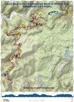
Description: The 59.2 mile Loyalsock Trail weaves its way through the State Forest bearing the same name (previously the Wyoming State Forest). It utilizes footpaths, old logging roads and railroad grades. This linear trip features steep climbs and descents, beautiful waterworks, nice campsites and five vistas. The last 2.1 miles are on the Worlds End Trail. If you are a purest and prefer to take the Loyalsock Trail all the way back to the park visitor center see the Loyalsock-Link Loop on this website. Google Maps Custom Driving Directions to World's End State Park Visitor Center Directions from World's End SP to the Brunnerdale Trailhead Make sure you register the vehicles you leave at the Visitor Center. If you don�t they will be towed. |
|
________________________________________ |
Zipped National Geographic TOPO! GPS and Universal GPX Files |
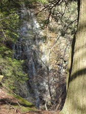
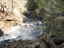
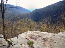
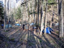
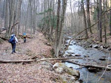
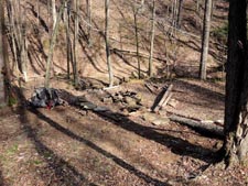
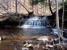
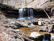
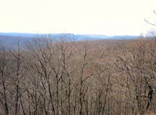
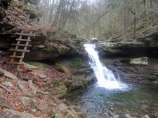
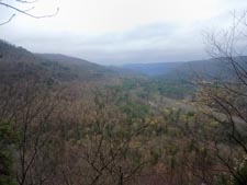
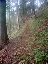
Trail Notes: The Loyalsock Trail (LT) is blazed with yellow disks with red LTs painted on them. The hike begins by following Ogdonia Creek downstream for a bit before turning right onto an old logging road. After the first switchback the hiker might feel that this will be an easy climb as the pitch of the road is very gradual. In 0.7 miles from leaving the parking lot the trail makes its first �jump� between levels of the road, turning sharply to the right and climbing very steeply for 0.1 miles. Turn left on the road again but in a mere 0.1 miles �jump� again, this time climbing steeply for 0.2 miles before finally reaching the junction with a blue blazed spur that leads to seventy foot Angel Falls and Springs Window. I strongly recommend dropping your pack and carrying your camera the 0.3 miles to take in these sights. There is more climbing to do but it is much more gradual. Keep a sharp eye out for blazes. As in during the initial climb, the trail might make use of a jeep road, but just for a few steps before leaving it for a footpath. The trail ascends and descends a southerly extension of the ridge before arriving at a beautiful vista overlooking Kettle Creek in 1.4 miles from the Angel Falls spur. There is a nice campsite here as well and a seasonal spring cascading over the rock face to its south. The trail descends 0.6 miles and then crosses Kettle Creek. This crossing can range in difficulty from a mere rock hop to a technically challenging rock hop. Turn right on an old railroad grade and almost immediately turn right into a nice campsite. There is a nicer one a little further up the trail. In 0.3 miles the trail turns abruptly to the left, leaving the grade, and climbing steeply. After leveling off you�ll cross an old dirt road in 1.0 miles and then descend 0.5 miles to beautiful Dutters Run. You�ll find a spacious campsite and a series of small waterfalls and cascades each with their own personal Jacuzzi. The trail crosses the stream several times before climbing back to the ridge and reaches Mary�s Window in 0.8 miles. A nice view of the Dry Run drainage is had here. Cross Dry Run Road in 0.5 miles. Here there is a stream and more potential camping areas. The trail follows the shadow of Nettle Ridge/High Knob for 1.6 miles. At least in the spring it can be very boggy. To your left will be a forest of hemlock. |
|
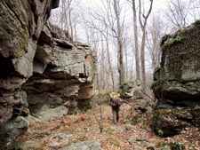
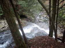
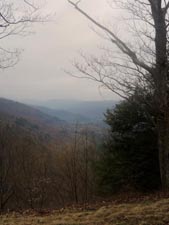
The LT turns right and climbs steeply up the face of High Knob with a few switchbacks at the top. Once at the top you can decide if you want to turn left on the road and walk the 0.3 miles to the official vista. Oh, did I mention there are vault latrines there? To continue cross the road and in another 0.6 miles cross it again (it�s a one way loop!). Here the LT follows a wide and grassy multi-use trail. In 0.1 miles the trail splits. Bear right, following the blazes. In 0.5 miles turn right onto a footpath that merges with another woods road. The trail leaves this to the left in another 0.2 miles. Cross the west fork of Cape Run in 0.2 miles and turn left onto another grade. Turn right onto a footpath and climb steeply, crossing the east fork of Cape Run. At the end of the climb turn right onto another woods road. Turn left. As the road turns to the right the LT stays straight on a footpath to visit Split Rock. If you wish to by-pass this just stay on the road as the LT will rejoin it shortly. In 0.4 miles from Split Rock the trail turns left onto another grade and descends for 1.0 miles to Ketchum Run. This particular grade is quite appealing as parts of it are lined with hemlock. Cross the run. To the left is a nice campsite but the ground is kind of �bumpy� with mounds here and there. Proceed downstream for another 0.2 miles to a much nicer site under the hemlocks and surrounded on three sides by water. If you continue on the LT you�ll arrive at the top of Lees Falls. A connector trail used to descend here and cross the run at the base of the falls but the trail on the other side has been obliterated by frequent flooding. It is no longer maintained. Here the trail turns right, away from the run, and climbs a short distance. In 0.6 miles from the last campsite the trail splits with the high water section being straight ahead and the low water section turning sharply to the left. I recommend taking the low water route but keep in mind the fact that the trail is narrow, oscillates up and down and is eroded in places. Also note that you have to make up for any elevation lost by taking this route. As you approach the run the trail goes in both directions. To the left is the remnants of the decommissioned connector trail. It leads to a nice set of mini-falls. To follow the LT turn right. Take your time so you don�t get hurt as you enjoy the cascades and Rodes Fall. The trail will climb and re-connect with the high water trail in 0.5 miles from leaving it. Turn left and in 0.4 miles arrive at the Lower Alpine Vista and its views of Loyalsock Creek. From here it�s 0.6 miles to the Alpine Vista. The first half is a tough slog up a steep, eroded trail. The remainder is on an old logging road. After taking in the view continue on the logging road passing through several hemlock groves. Cross Coal Mine Road in 0.3 miles. The LT will then cross a power line swath and turn right to parallel it, arriving at the junction with the Worlds End Trail in 1.0 miles from the road crossing. Turn left onto the wide dual blazed (blue and yellow) multi-use trail. In 0.4 miles find yourself once again standing on Coal Mine Road (It�s a loop!). The yellow segment continues across the road as a footpath. Turn right on the road and follow the blue blazes for 0.4 miles, turning left onto the continuation of the trail at marker 14. In 1.3 miles the yellow and blue trail segments meet ach other again. Turn right and follow the yellow blazes as it rapidly descends for 0.7 miles through a series of steep and narrow switchbacks to the visitor center below.
________________________________________ Photos by Craig Ross
________________________________________ |
|
|