|
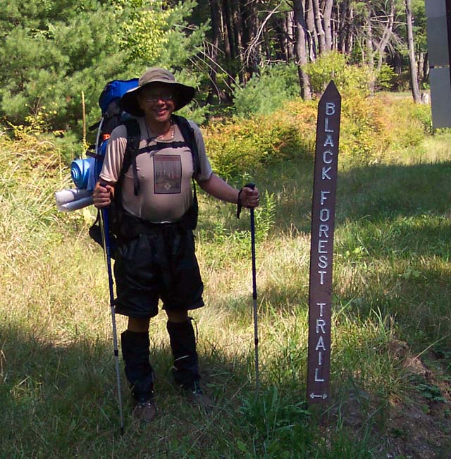
Black Forest Trail - North
I would like to thank Scott Adams of
http://www.pahikes.com and
some hiker dude called Pennsy for their guidance as I researched
this trip. |
|
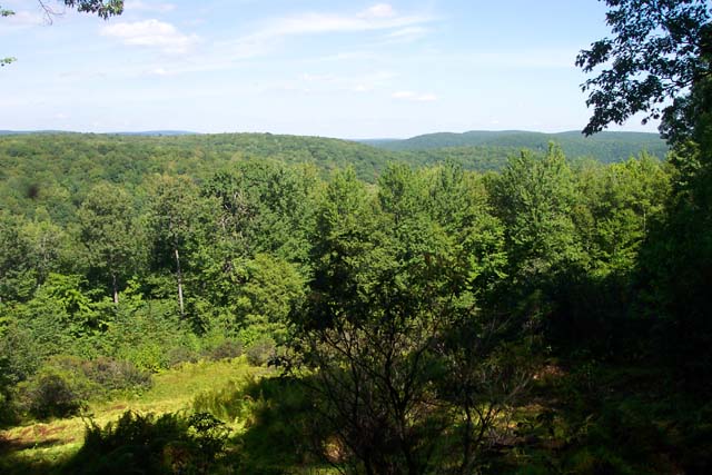
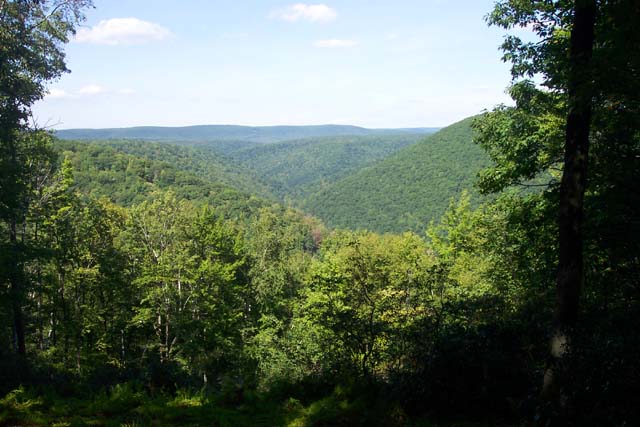
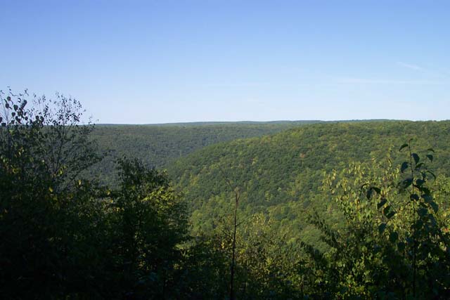
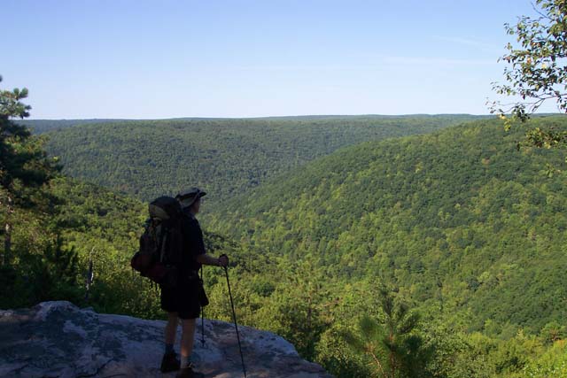
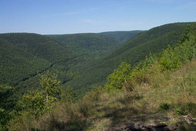
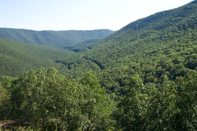
Description: The Black Forest in PA is a small part of the Tiadaghton State Forest. It is to PA what Dolly Sods is to WV, one of the prized gems of that state�s crown hiking jewels. The Black Forest Trail proper (BFT) is a 42 mile circuit that takes you through valleys and along ridge tops. It is interspersed with easy flat walks and rocky steep ascents and descents, some averaging 1100 feet elevation change in less than 0.7 miles. That�s steep! The hiker is rewarded by his/her effort with astounding views of the surrounding peaks and valleys and an assortment of forest types ranging from Pine Plantations, giant Hemlocks and Red Spruce to a mixture of Hardwoods and other deciduous trees. Wildlife you might encounter include, but is not limited to, turkey, grouse, deer, raccoon, porcupine, screech owls and black bear.
As this description implies, it�s not necessary to hike the entire 42 mile circuit to enjoy the Black Forest. You can either setup a shuttle or use the many additional ski trails, forest trails and roads to form shorter loops. The following describes what I consider to be the northern section of the trail which is connected by the Pine Bog Trail, Blackberry Trail and less than 0.5 miles of forest road walking. Maps and details for the southern section, using the same cross connectors, can be found here. Google Custom Directions |
|
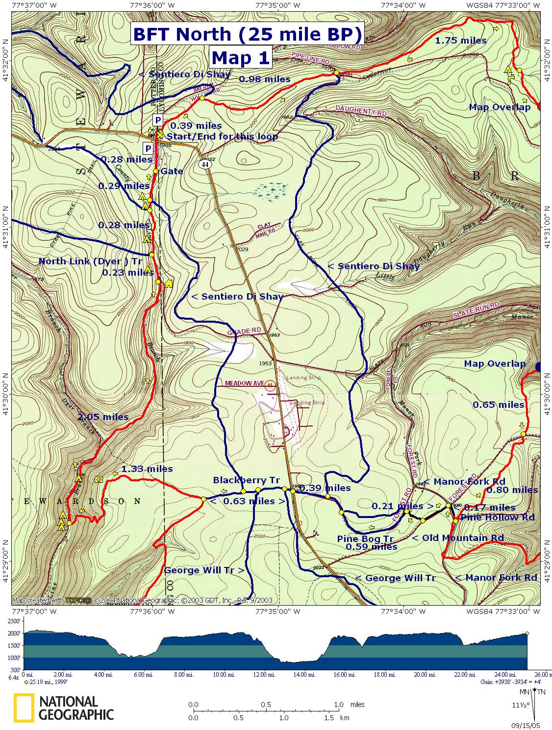
There is parking on either side of Rt44.
DO NOT PARK IN FRONT OF THE WHITE HUNTING CABIN ON BIG DAM
HOLLOW RD DURING HUNTING SEASON!!!
The hike begins at a set of steps between the cabin and Rt44.
Look for the orange circles. _____________________________________ |
|
Zipped National Geographic. TOPO! GPS and Universal GPX Files |
Trail
notes:
The Black Forest Trail (BFT) is blazed with orange circles (shown in
red on the map). The cross-country ski trails and other footpaths
are either blazed in blue circles or blue rectangles. The mileage
breakdown for a 3 day trek is 5.6 � 6.4/ 10.1 � 10.9/8.5. The exact
distance traveled for day 1 and 2 depends on where you camp. You can
vary the distances but beware: There is only one unreliable water
source after you climb out of the first valley until you descend
again to Slate Run. This source is not near a
campsite.
Day
1: Walk down the steps and follow the trail as it parallels Big Dam
Hollow Rd. Pass another Hunter�s cabin on the right. In 0.39 miles
the Sentiero Di Shay Ski Trail comes in from the left and shares the
tread for a bit. You will witness three nice views between here and
the first night�s camp. In another 0.98 mile the Ski trail leaves on
the right.
In
1.75 miles arrive at a camp w/small stream. Continue on. In 1.56
miles you will descend to Francis Rd. Turn left on the road. In
about 0.36 miles turn right onto a RR grade. Soon leave the grade
and descend on a footpath to Morris Branch Rd. Turn right here,
passing a kiosk on the right and crossing the Francis branch of
Slate Run on a concrete bridge.
Turn
right off of Morris Branch Rd onto a footpath that leads to a
footbridge over Morris Run. A nice campsite is to the left, before
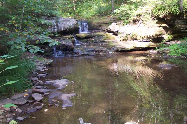
crossing, right beside a waterfall.
If
you wish to continue, cross the bridge and climb steeply for a few
yards to a pretty level RR grade. In the next mile you will pass 3
nice campsites before reaching a steep rocky climb out of the
valley. Before these sites there is an unmarked trail to the right that goes
down to the stream. I do not know if there is a campsite there.
(A recent
site visitor insures us there is.)
Two
campsites will be on the right and the third is right at the base of
the hill on the left, across a stream. Unless you had gotten an
early start and plan to reach the lower portion of Slate Run by
day�s end I would go no further until the next
day.
Day
2: From camp climb approximately 700 feet in less than 0.7 miles to
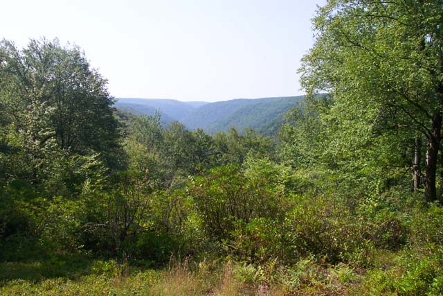
the top of the eastern ridge. Almost immediately you will be
rewarded with back-to-back views of the Slate Run valley and
surrounding ridges. Continue on for about 0.48 miles. The junction
of blue blazed Alcinda trail will be on the left. You can use this
as a short cut but you will miss another great view. Stay on the BFT
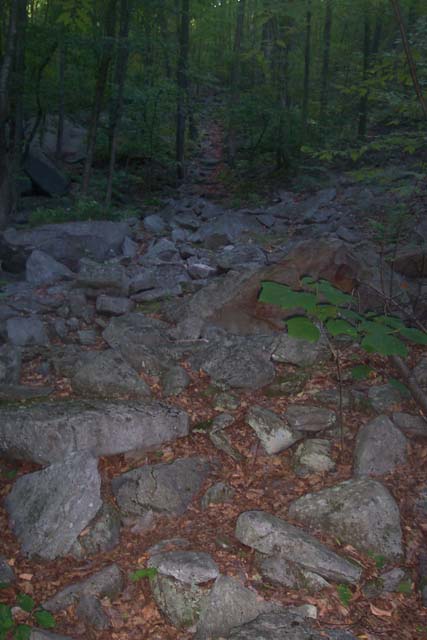
and descend along a boulder field to this view. Continue on and in
0.68 miles from the last trail junction pass the Alcinda Tr on the
left again.
In
about 0.4 miles you will pass some unmarked trails on the right that
lead to some gigantic table rocks. Continue straight on the BFT for
0.67 miles to the junction with blue blazed Algerine Tr on the left.
Make a hard right to stay on the BFT. In 0.74 miles pass a small
spring on the left and in another 1.22 miles arrive at a dry
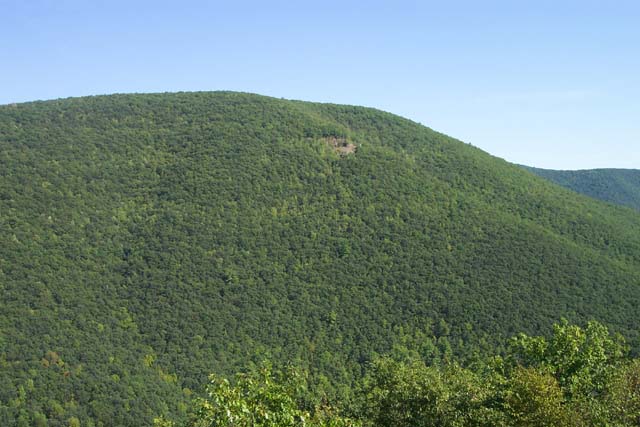
campsite and the remains of a quarry. From here you can enjoy a 180
degree view of the forest.
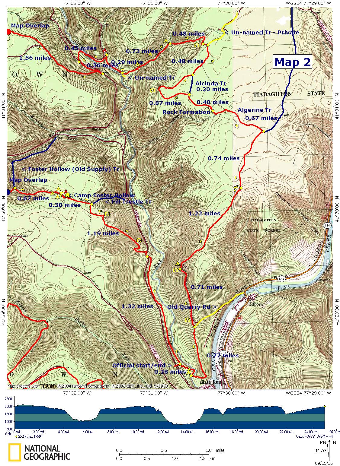
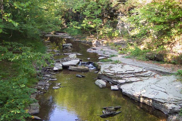
From here the tread follows the old quarry road to a smaller quarry w/view. In about 0.71 miles from the upper quarry the road will rap around the mountain to the left. Leave the road, descending steeply on a footpath. Near the bottom the grade will lessen somewhat and switchback to a wide ford of Slate Run at 0.77 miles from leaving the quarry road. |
|
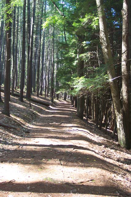
Here you may find a sign leaning on a tree directing you to turn left to a footbridge during periods of high water. As of this writing that bridge is not usable, having been severely damaged by high water. Cross the run and turn right to pick up the trail which passes through a huge camping area before climbing to a RR grade. You will follow this grade through beautiful pines on the left and Hemlocks on the right.
Pass a orange blazed spur trail on the left (0.28 miles from the ford) that leads out to parking and the official 0.0/42.0 BFT trailhead. Continue straight. You will descend on a footpath to another RR grade. Turn left onto the grade. The trail will leave and then rejoin the grade before finally climbing on a footpath to Slate Run forest road 1.32 miles from passing the official trailhead spur. Turn right onto the road and then left back onto a footpath.
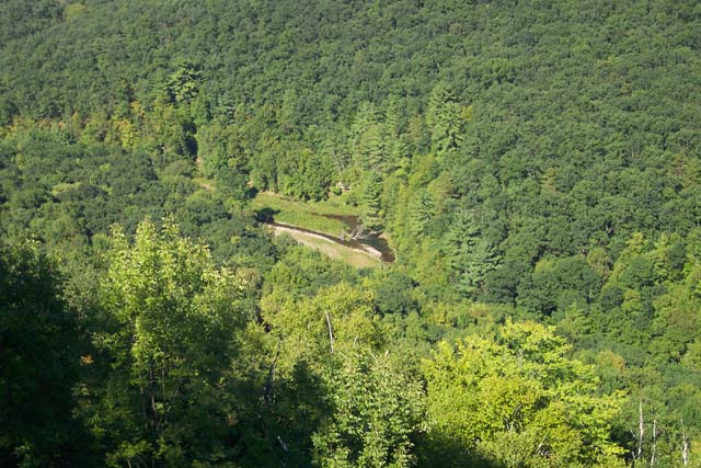
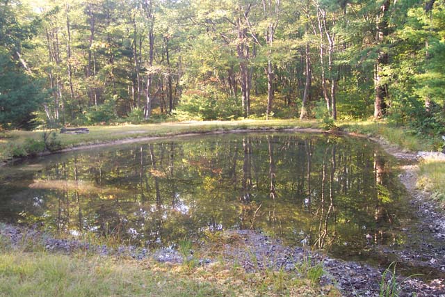
Switchback through High Trestle Hollow to the spine of the ridge. Climb steeply through the rocks of � The Lemon Squeezer�, passing 2 great vistas before reaching yet one more just beyond the summit. In about 1.19 miles from leaving the forest road pass High Trestle Trail on the right. In 0.3 miles arrive at camp Foster Hollow hunting cabin and tonight�s campsite. DO NOT CAMP NEAR THE CABIN!!! There are places to camp around the pond plus more sites hidden in the woods that can be reached by short spur trails. The pond water is potable after filtering/treatment.
Day 3: Follow the trail around the pond and descend along a steep rocky trail for 0.67 miles to the junction of the Foster Hollow Trail on the right. The old sign still calls it the Old Supply trail. There is a campsite at the confluence of 2 streams. I didn�t show it on the map since both streams were dry as of this writing. Make a hard left turn here, continuing to follow the BFT, and climb steeply along another rocky drainage to the top of the plateau.
In 0.65 miles from the Old Supply Tr junction, cross Old Mountain Road (no sign here). The BFT will parallel this road for about 0.8 miles before arriving at the signed junction of Pine Hollow and Manor Fork roads. Turn right onto Manor Fork Road. Soon turn left onto signed Old Mountain Road. In 0.2 miles arrive at a driveway on the right that leads to a green hunting cabin. On the other side of the cabin there is an obvious footpath that crosses a stream on a split log bridge before connecting with blue blazed Pine Bog Tr (Left and right, no sign here). Either direction will get you out to Rt44. I have you turning left here. In about 0.59 miles both sides of the Pine Bog Tr will come together. Continue straight, passing the unsigned junction of Senterio Di Shay Ski Tr on the right. In another 0.39 miles the trail joins a driveway before ending at a parking area near Rt44.
Cross Rt44 and follow the Blackberry /Sentiero Di Shay Trails west. Almost immediately the George Will Trail will join in from the left. It will soon also leave on the left. Continue straight. The Ski trail will leave on the right. (Note: If you know in advance that the water level on County Line Branch will be high or treacherous or if you prefer a quicker route back to your car for other reasons turn right here and follow the Ski trail until it reconnects with the BFT about 0.5 miles from Rt44.) Stay straight. In about 0.63 miles from crossing Rt44 the orange blazed BFT will come in from the left. Stay straight to continue on the BFT. The Blackberry Tr ends here.
In about 0.7 miles you will arrive at the last vista of the trip before descending through a field of huge boulders. Cross County Line Branch in another 0.6 miles. There is great camping here and further up the stream. Turn right onto a RR grade and follow it upstream. Follow the blazes carefully. There are places where the trail leaves this main grade on the west side of the stream and crosses the branch to the east side only to rejoin the main grade at other places. At some point the trail will leave the main grade for good as it (the main grade) turns more westerly and up the Dyer Branch. The trail will follow another grade due north. Follow it. Including the initial crossing you will cross the County Line Branch 20 times. This can be tricky during periods of high water.
At 2.05 miles from the first ford arrive at a forest road. Turn left
here. Pass a spring on the right and then a leased hunting cabin. An
orange blaze is mounted on a game trellis. Cross a small stream on a
bridge. In 0.23 miles pass a campsite in the pines on the left and
Dyer/North Link Tr also on the left. In another 0.28 miles pass
junctions of the Ski trail on first the left and then the right.
Walk around a forest gate at 0.29 miles and in another 0.28 miles
reach RT44. If you parked near the hunting Cabin at the start of the
trek cross the road to get back to your car. Printable/Downloadable Directions and Trail Notes Critique this outing ______________________________________
______________________________________ Name: Steve Outing Critique: This was mine and my wife's first backpacking trip. We decided to make it a two day trip instead of a 3 day. Day one we went from 44 down to Slate Run. We ate lunch at the suggested first nights campsite. We made our way all the way down to Slate Run curious if there was a usable bridge there. THERE IS A NEW HIKING BRIDGE THAT CROSSES SLATE RUN NEAR THE HOTEL. It is very nice, no need to worry about fording the run. I used this webpage as our guide for the trail, and it was spot on (thank you!!) It started raining @ 12:30 at night, and it rained for almost 12 hours (supposedly 3" that night!). The streams were so high and fast, we felt they we not safe to cross, so, we cut the trail short and walked the roads back to the car on 44. One other thing worth noting, there is another parking area on 44 (looks newer). Coming from the south, it's just before the "God's Country" sign on the right. Other then the rain cutting our hike short, our first 13ish miles were awesome! ______________________________________ Name: Dan Hike: Black Forest Trail-Total Date(s): 06/28-29/14 Rating: 5
Critique: Did the entire loop over 2 days. Absolutely beautiful and I saw no over night backpackers anywhere. Be prepared for a lot of ups and downs but they are well worth it. The vistas, creeks, waterfalls are just outstanding and I'll definitely be back to hike some of the sections I really liked with my son. I had planned on a three day hike but since I did 19 miles the first day and there were possible storms Sunday night I figured I could do the last 24 miles Sunday. I paid for the 24 mile Sunday hike with sore quads and hips that night. My recommendations for anyone doing this is to go light and enjoy. No need for heavy boots and packs that weigh 40+ lbs. I cowboy camped Saturday night under the stars and listened to the bubbling brook for music. I would not do this hike clockwise do to some of the ascents. Counter clockwise is the way to go. Be alert for the wildlife. I almost got it from a rattle snake by not paying attention to what I was doing. Go out and do this hike. Its a true gem of Pa and take Pictures!
______________________________________
Name: Dick/Roger Hike: Black Forest Trail - North 05/11-13/13 Rating: 3-4
Critique: We delayed starting out by one day due to weather, but still passed through rain in Williamsport on the way! In total the Williamsport area received 1.80 " of rain from 5/09-12. View this as the lower limit for defining the trails as being "high water"! Checking the rainfall in the area, particularly in the Spring, is a must before going! This is critical because during Day 2 you have to ford Slate Run... there is no bridge left because it continually was washed out! If you can't ford it you have to backtrack up to the Old Quarry Road and go right down to an old steel bridge on Pine Creek, then up Rt44 for over a mile to the Black Forest circumnavigation parking area above Slate Run. We forded Slate Run in high water (mid-thigh running around 6mph). Neither of us will ever do that again...extremely dangerous and foolish! On the positive (and sane) side, it's a really nice hike! The ridges have oceans of mountain laurel. Next year we'll go back around the first week in June when it reported blooms up there! The lower elevations have very nice conifer groves. The vistas are pristine in terms of seeing no signs of civilization! The trails are well maintained with only a couple of rocky spots! The first night we camped at the furthest campsite up Morris Branch before the climb out of the valley! It would handle 3-4 tents, the second site was also nice, but smaller (2 tents). The first along the branch was not as good! (We didn't go down the initial path to see whether there's a good site there)! The second night we camped at Foster Hollow! Multiple level sites near the pond including off trail in the woods! The pond water was very clear and flowing through from and into a creek! Whether this continues thru the summer is a question, but it looks as if it would! Because of high water we chose to take the Sentiero Dishay ski trail (marked as the "high water alternative") back up north instead of going further west to the BFT on County Line Creek! It had some bogs and places where it was hard to follow. The Dishay is now clearly marked off of the Blackberry Trail! However, where it meets Meadow Rd. the road crosses and now continues west. When widening the road they apparently wiped out any visible blue blazes. Go right on Meadow Rd for about fifty yards to the other side of the creek where you'll see ample blazes on the left side of the road Also, there is a new road that you'll cross before coming to Gravel Rd. We're guessing that they're getting ready to "frack" in the area! Oh yes, by the way, it was snowing and sleeting while hiking (13th of May).. not detrimental to enjoying the hike though!! Bottom-line: With less rainfall immediately before it, and with the laurel in bloom, this would be a really outstanding hike! It was a very nice one as it was! Stopping at the Bullfrog Brewery in Williamsport on the return provided closure!
______________________________________
Name: Jordan Abbott
Hike: Black Forest Trail - North
______________________________________
Name: .com
Hike: Black Forest North ______________________________________
Name: John
Hike: BFT (total loop)
______________________________________
Name: Chris
Hike: Black Forest Trail - North ______________________________________
Name: Tim Marshall
Hike: BFT (total loop - 42 miles)
______________________________________
Name: Reid
Hike: BFT (total loop - 42 mile) ______________________________________
Name: Gerard Viau
Hike: Black Forest Trail - complete
______________________________________
Name: zach
Hike: Black Forest Trail North and South
______________________________________
Name: Jonny
Hike: Black Forest trail
______________________________________ Name: Ron
Hike: Black Forest Trail North ______________________________________ Name: Hitman
Hike: Northern Section BFT ______________________________________ Name: PowderKeg
Hike: Black Forest Trail - North ______________________________________
Name: Bob Tarabula
Hike:
Black Forest North ______________________________________ Name: Scott Adams Hike: Black Forest Trail - North Date: 9/16/2005
Ranking: 5 Critique: Nice job on your TR of the Black Forest Trail. Glad you liked the hike and the region: the BFT is my favorite trail in all of PA. Hope to catch up with you and hike along next year when you return to finish the remainder of the trail. ______________________________________ Name:
Bob Gabart
Hike:
Black Forest - North M.R. Hyker Note: Bob may be right for fall/winter hikes but I like to be near water in the summer and am opposed to carrying any extra weight on my back unless I have to. Re: the campsite down in Foster Hollow: The streams there are quite seasonal so beware. ________________________________________
Name: Craig
Hike:
Black Forest Tr - North BP ______________________________________
Name: Mike
Hike: Black Forrest Trail - North Loop ______________________________________
Name: Stefan
Hike:
Black Forest Tr-North ______________________________________ |
|
|