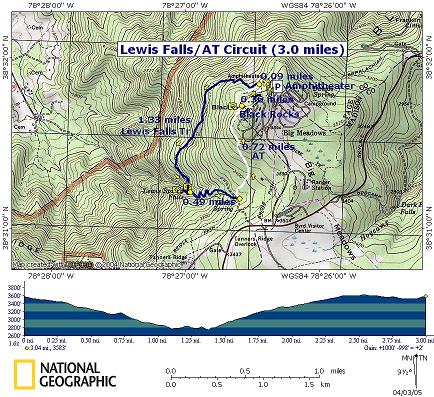
|
Lewis Falls/AT Loop |
|
Description: This is a 3 mile moderate loop in
the SNP. If this hike was 2 miles longer or done in conjunction with
the
Rose River/Dark
Hollow Loop also described on this site I would probably considerate it to be
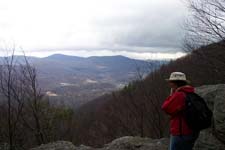
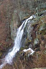
strenuous. It includes a couple of great viewing platforms along the
Lewis Falls Trail, one along the AT at Black Rocks and spectacular
|
|
______________________________________ |
Zipped National Geographic. TOPO! GPS and Universal GPX Files |
Trail Notes: From the amphitheater take the spur trail on its left down to the AT.
Turn left onto the AT and in about .09 nine miles arrive at the junction with blue blazed Lewis Falls Trail on the right. Take the Lewis Falls Trail. At first the trail is easy to walk but as you get closer to the falls it becomes much rockier. Near the end you will have to walk over a couple of large boulders.
In 1.3 miles arrive at the falls spur trail straight ahead. Follow it, crossing the stream as you descend to the viewing parapet. A handrail has been installed to assist you should the rocks be slippery. After viewing the falls return to the junction with the main trail. Turn right and ascend steeply for about 0.5 miles.
The trail switchbacks up the side of the mountain and then widens into a gravel road. From this point walk another 70 yards, passing an enclosed pumping station on the left, to the junction with the AT. Turn left onto the AT, still ascending but on a much more gradual grade and reach Black Rock Overlook in another 0.72 miles. You�ll pass a side trail to Big Meadows Lodge on the right before reaching the overlook. After taking in the view continue north on the AT and in another 0.36 miles arrive at the original junction with Lewis Falls Trail. Retrace your initial steps back to the car. |
|
________________________________________
________________________________________
Name: Duane C
Hike:
Lewis Falls/AT Loop ________________________________________
Name: Michael Eckert
Hike:
AT/Lewis Falls ________________________________________ |
|
|