|
Bull Run Mountain Conservancy |
|
|
Description: The
Custom Google Directions Hike begins at the Mountain House at the end of Beverly Mill Rd. |
|
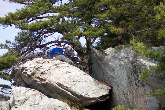
For Immediate Release November 25, 2024 Contact for info, photos, and interviews: Amanda Scheps, (540) 347-7727 x227, [email protected] Virginia Outdoors Foundation announces closure on portion of Bull Run Mountains Natural Area Preserve The High Point cliff area on the Bull Run Mountains Natural Area Preserve will be closed for an indefinite period of recovery and restoration starting January 15, 2015. The cliff area at High Point is a particularly fragile and significant natural community known as a Pine-Oak / Heath Woodland. Both the vegetation and the geological formation that supports it represent important natural resources in Virginia that have been damaged by trampling. Sensitive species such as the eastern timber rattlesnake and the Table Mountain pine have been disturbed by high numbers of visitors. Six miles of public access trails in the preserve will remain open for hiking. The cliff area is part of the 2,500-acre preserve, but is privately owned. Access is managed under a license agreement that enables the Virginia Outdoors Foundation (VOF) to provide natural resource protection for the habitat while permitting the public to visit the cliffs. The closure will be implemented by VOF in accordance with a recovery plan designed in collaboration with the Virginia Department of Conservation and Recreation�s Division of Natural Heritage, whose staff will monitor the effects of closure on the damaged habitat. The duration of the closure will depend on the rate of recovery and the public�s adherence to current and future use guidelines. Visitors to the preserve must respect the closure of the High Point cliff area. At the time of closure, the Bull Run Ridge Trail beyond its juncture with Fern Hollow Trail and the Hickory Trail beyond its juncture with Quarry Trail will be closed. Ninety percent of the preserve is owned by VOF. The properties were officially dedicated as a State Natural Area Preserve in 2002 in recognition of their significant natural resources. The preserve straddles the border of Fauquier and Prince William counties. For questions and more information, contact Amanda Scheps at (540) 347-7727, [email protected]. ________________________________________ |
|
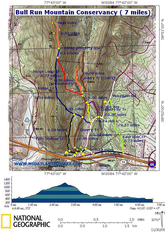
Zipped National Geographic. TOPO! GPS and Universal GPX Files |
Trail
Notes: The conservancy uses a unique trail marking system
designed and installed by Boy Scouts. Each trail intersection has a
post with colored discs.
Note that there are
still blazes on the trees. These are from previous management and
may not match the color on the post. Post color has priority! Also,
as of 11/05 the color coding of some trails have been changed and
some trails have been combined. Unofficial, unsigned or unblazed
trails are shown as orange on this map. The following description
uses these changes. Some, but not all, of the
intersections have signs. What is there is correct. Also note that
the section of Ridge Trail north of the BRMC boundary is not under
the Conservancy�s jurisdiction and is not blazed or maintained.
Finally, the map shows an �un-named� trail that parallels the Old
Quarry Trail (Blue) and follows the northern portion of Cattlet�s
Run. This is not an official trail but one worth exploring.
Starting
at the trailhead kiosk cross the railroad tracks. Soon come to the
intersection of
Turn right at this junction and soon come to the ruins of another old mill as the Fern Hollow Trail (Black disc)turn right and begins a gradual ascent. At 0.52 miles from the last mill arrive at the Ridge Tr (Blue disc). Turn left on the Ridge trail and continue to climb, steeply at first. As you reach the ridge line the trail will bear right onto an old woods road. In 0.9 miles pass the junction of the Ridge loop Trail (Red disc but might look orange due to fading) on the right. The trail post is on the left. In another 0.16 miles you�ll be off of Conservancy property. Continue to follow the old road for another 0.33 miles. |
|
You�ll
have to work your way around some fallen trees but keep bearing
to the west to find the trail. Shortly after leaving the
conservancy the trail splits, just behind a fallen tree. You
want to bear to the left, staying in sight of the ridge. As you
near the crest of the hill the trail and ridge line come closer
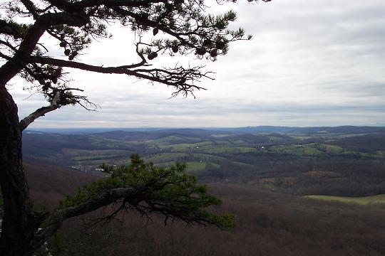
together. At this point there is a great viewing platform called
Return
to the junction of the Ridge
Retrace
your steps to the junction of the Ridge
At 0.78
miles from the previous trail junction come to
Printable/Downloadable Directions and Trail Notes ________________________________________
________________________________________
Name: Dave
Hike: Bull Run Mountain ________________________________________ Name:
Lane
Hike: BRMC - skipped Quarry Tr spur ________________________________________ Name:
gale
Hike: Bull Run Mountain Conservancy ________________________________________ Name:
Dave
Hike: Bull Run Mountain Conservancy Overall a good hike that I would recommend for a a fun afternoon. ________________________________________ Name:
Chris
Hike: Bull Run Mountain Conservancy ________________________________________ Name:
S. Helberg
Hike: Bull Run Mountain Conservancy ________________________________________ Name:
dcmidnight
Hike: Bull Run Mountain ________________________________________ Name:
L. Arbogast
Hike: Bull Run Mountain |
|
|