|
AT/Laurel Prong Loop (Camp Hoover) |
|
Description:
This
is a moderate 10 mile circuit in the SNP. Although
|
|
You�ll
then descend to the Camp on the Laurel Prong Trail. After you finish
soaking in the history you�ll return to the
The hike starts behind the Byrd Visitor Center. ___________________________________ |
Zipped National Geographic. TOPO! GPS and Universal GPX Files |
Trail
Notes: From
the
In about
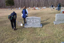
0.38 miles arrive at gravel Tanner Ridge Road (Way Point 001B). Turn
right and follow the road to the cemetery. After checking out the
grave stones, turn right onto the AT (Way Point 002). In another
1.03 miles arrive at the Milam Gap parking area on
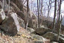
Cross the Drive and continue on the AT passing the trailhead for the Mill Prong Trail. Slowly climb up to Hazel top, enjoying partial views east of the valleys and peaks. Descend and at 2.34 miles from crossing the Drive arrive at the junction of blue-blazed Laurel Prong Trail (Way Point 004).
In
another 0.9 miles arrive at the junction of Cat Knob Trail (Way
Point 005). Turn left to stay on Laurel Prong Trail.
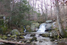
Descend and in about 0.66 miles come to the first of several streams and springs that comprise the headwaters of Laurel Prong (Way Point 006).
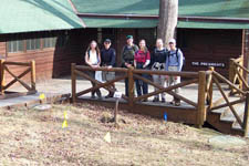
In 0.63 miles pass the junction of Fork Mountain Trail on the right (Way Point 007). Soon after this junction the blazes will change from blue to yellow although you are still on the same trail. Pass the �Five Tents� area on the left.
At 0.53
miles from the last trail junction arrive at
|
|
Return to the junction of Laurel Prong and Mill Prong Trails. You passed it as you came into the camp. Follow the signs for Mill Prong Trail. Initially you�ll be following a gravel entrance road but soon look for and turn left at a concrete post marking the continuation of the yellow-blazed trail as a footpath that parallels the stream.
In 0.35
miles (Way Point 009) from leaving the camp, come to
Arrive
at the junction of yellow-blazed Mill Prong Spur Trail in another
0.33 miles (Way Point 010). Turn right onto the spur trail and
climb, steeply at times, for 0.98 miles to the junction of the
Turn
left onto the Printable/Downloadable Directions and Trail Notes _______________________________________
_______________________________________
Name: Michael Eckert
Hike:AT/Laurel Prong Loop (Camp Hoover) _______________________________________
Name: Carol Branscome
Hike:
AT/Laurel Prong Loop (Camp Hoover) _______________________________________ |
|
|