|
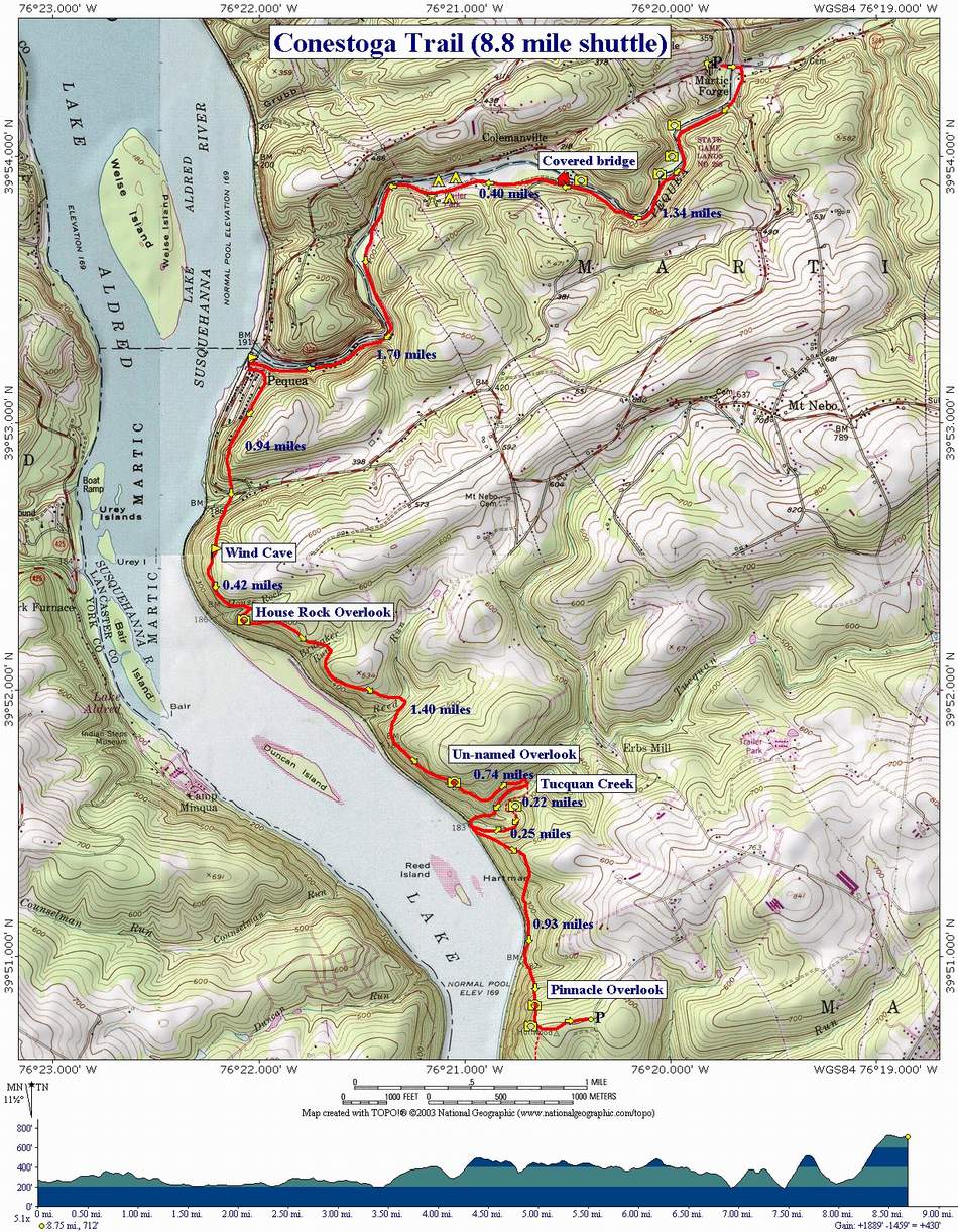
Conestoga Trail Shuttle |
|
Description: This is an 8.8 mile
strenuous shuttle hike in the Holtwood Recreation Area along
Google Custom Directions to southern car drop-off at Pinnacle Overlook Google Custom Directions to the northern Martic Forge Trailhead From here hike back down to the ruins of the Old Martic Forge Hotel on River Road to start the hike. |
| _______________________________________ |
|
|
Trail Notes:
The
Conestoga Trail is blazed orange. A slanted double blaze denotes a
change in direction. In rocky areas, the rocks themselves may be
blazed.
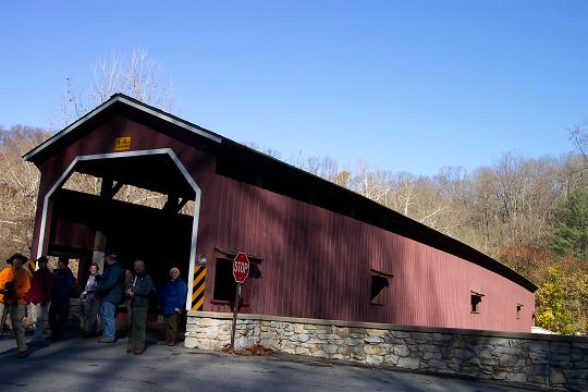
Re-cross the bridge
and turn right onto
At 0.4 miles from the
covered bridge, walk through Pequea Campground. Ice Cream can be
purchased at the camp store in season. The trail continues on the
other side of the campground. You will walk along a gravel road with
summer homes (many of them derelict and ready to come down) high up
on the hill to the left.
At 1.7 miles from the
campground pass Pequea Boat Club on the right. The blazes and this
map direct you to turn left onto
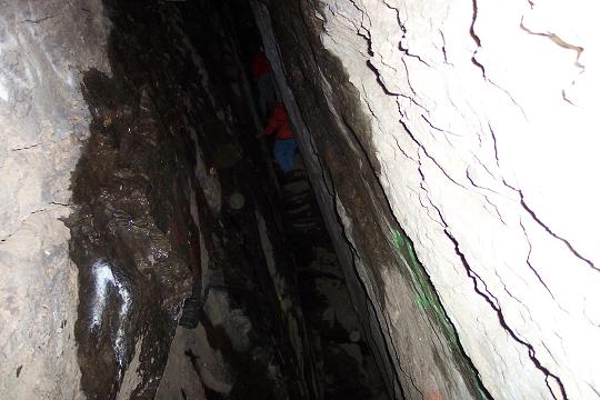
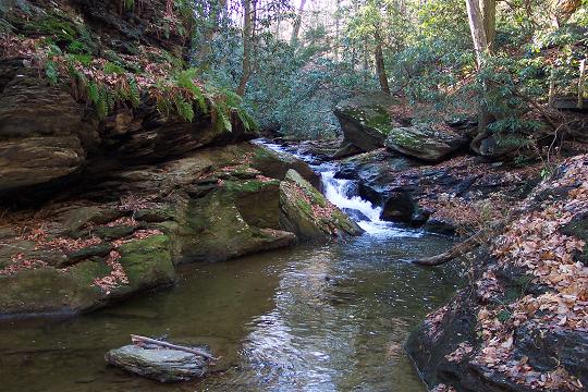
From the wind cave proceed to climb, sometimes through the rocks to the top of the ridge. In 0.42 miles you will descend through an area called Fat Pack Squeeze, cross House Rock Run and climb to House Rock Overlook.
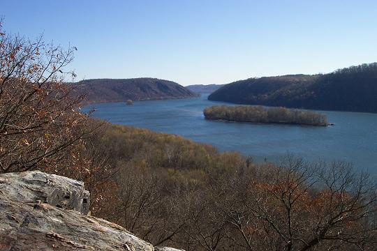
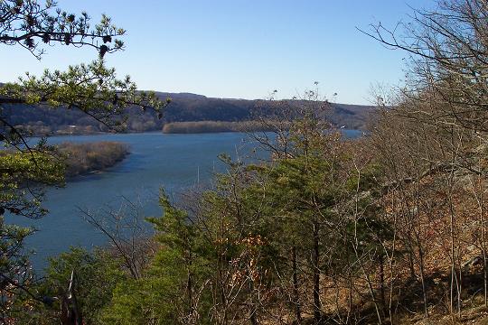
Over the next 1.4 miles you will descend and climb through two small coves, crossing small streams as you go, and visit another overlook before descending towards Tucquan Creek. |
|
If
you are prepared for a stream crossing you can cross an unmarked
trail and follow the orange
blazes across and down Tucquan Creek to the railroad tracks. Since I
usually lead this hike in the cold months I turn right on the
unmarked trail. At it�s crest it becomes a woods road. Follow this
down towards the tracks. Towards the bottom turn left onto a
footpath and follow it down to the tracks.
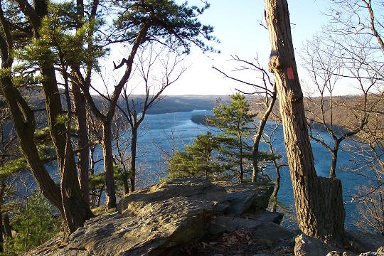
To complete the hike return to the tracks and turn left. Climb back up to the ridge. Shortly after reaching the top you will turn left onto a woods road. In a short distance you will turn right onto another footpath and slowly descend to the base of the Pinnacle ( about 0.7 miles from Tucquan Creek).
Begin a steep climb up
to a prominent rock out crop on the right and at 0.25 miles from the
start of the climb arrive at the Pinnacle Overlook parking area.
Printable/Downloadable Directions and Trail Notes ________________________________________
________________________________________
Name: GaliWalker
________________________________________ Name: Sushant Hike: Conestoga Trail Date: 05/02/15 Rating: 3.5
Critique: We
parked our car near Pinnacle Overlook and went all the way to
Martie Forge and then all the way back to Pinnacle Overlook. ________________________________________
Name: Dar Hike: Conestoga Trail (modified) Date: 05/25/13 Rating: 5
Critique: Lovely hike and deserving of the strenuous rating. We didn't want to take two cars for the shuttle hike so we decided on starting at the Pinnacle Rock Overlook parking lot and doing an out and back to the Wind Cave. We overshot the Wind Cave a bit on the way north (easy to hike right by northbound, hard to miss southbound) and went past it to the woods road before turning around. Total mileage was 9.1 with a total elevation change of 2500 feet each way according to our GPS tracker program for a total hike elevation change of 5000 feet. It's a death by a thousand small, steep hills kind of trail so be prepared to be tired. I realize that was doubly so for us because we chose the hilliest part for the out and back but I'd still highly recommend this hike. Really nice scenery and cool with lots of shade, breezes and waterways along the route. The Tuquan Creek stretch is particularly lovely and a great break from the harder bits to either side of it. We did the stream crossing and found a place about 10-15 feet past the actual marked crossing where we could rock hop without really getting our feet wet. The blazes are much improved from the previous years' comments. In fact this trail is now very well blazed. We had no trouble following the orange blazes - the turns were well marked as were the bits going over and through rock formations, and the orange Conestoga trail was easy to distinguish when it ran alongside other trails and then split off from them. At some points you may need to pause and look for the markings (ie- around the rock formations) but they are there and easy to make out. Note that 3 other trails run alongside on the Tuquan Creek stretch (blue-blazed Tuquan Glen on the south bank and white and yellow trails on the north side) so just watch for blazes marking the split offs for the Conestoga trail- they are slanted double slashed and well-marked.
________________________________________
Name: Greg
Hike: Kelly's Run to Covered Bridge on Conestoga Trail ________________________________________
Name: Ken Fillo
Hike: Conestoga trail
________________________________________
Name: Bob Hike: Conestoga Trail Shuttle
Date: 5/18/07
Rating: 3.5
I did the
Conestoga Trail shuttle recently and truly enjoyed the hike.
Due to transportation limitations, I hiked this trail in the
opposite direction of the guide above. I parked at the north
end and got dropped off at Holtwood Park, starting at the
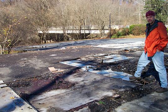
trailhead for Kelly's Run. As for the north end, the old Martic
Forge Hotel is no longer there, and parking was simple alongside
the foundation. By starting at Kelly's Run, I added a few extra
miles, albeit scenic ones, to my trip.
The rock
outcrop just a few hundred yards north of the official
overlook parking provides beautiful scenery and a great place to
stop for photos. The descent from the Pinnacle has some
large trees down, and it's relatively steep, but it's clearly
marked and has stable footing. The trail emptied out at the
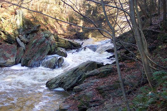
railroad tracks, cut right, and followed along Tucquan Glen for
a short distance beyond the above mentioned wooden bridge. The
water at the crossing was higher than my boots, but about 20
yards downstream was large tree that made for an easy, and dry,
crossing. The climb up the other side was straight up, with
several very large downed trees.
Eventually you
get to an un-named overlook, which was actually my favorite of
the hike. There are several rock formations to climb up, and
around, at various locations on this hike. House Rock overlook
was trashed. I was carrying a full/heavy pack as an extra
challenge, and had no room for all the trash there. Next time
I'll bring a rubber glove and trash bag.
Once I
descended from Wind Cave, I got to service road and the orange
blazes ended. Downhill was the railroad that would have taken
me into Pequea and to the marina and around, but to save time
off my trip I turned uphill for about 1/2 mile and cut through
to the campground under the power lines. I picked up the
markers again in the campground, and the walk back to car was a
flat, easy straight walk, and a nice chance to reflect on a
great day hiking.
Generally
speaking, I concur with the strenuous rating, mostly due to the
hills. This was my first time on this trail, and I was carrying
a pack for the additional challenge. With all the hills, I was
definitely presented with a challenge. Some of the trail is
right alongside private property. The owner has clearly, and
frequently, posted signs to keep out, so please honor that. The
trail was generally easy to follow in amongst the trees, but
many of the trees with markers were down along the side of the
trail. Up in the rocky regions it wasn't quite so simple. Some
markers were sparse, or too low and you couldn't see them when
looking uphill.
Overall, I'd
say this trail is a hidden gem, even if it's "in the rough."
Plenty of elevation changes, several scenic overlooks, creek
crossings, and a variety of ground conditions. This is a great
hike to try and develop a variety of techniques. All in all, I
like the more rugged portion of the hike. Next time, I'll
probably go just from Kelly's Run to the marina in Pequea.
________________________________________
Name: Dan D
Hike:
Conestoga Shuttle ________________________________________ |
|
|