|
|
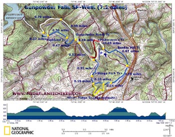
Gunpowder Falls West Circuit
Description: To begin
with, the name
This is a 7.2 mile moderate
figure-8 hike close to
Th The hike starts in a large parking lot on the left side of Bunker Hill Rd at the bottom of the hill. |
Zipped National Geographic. TOPO! GPS and Universal GPX Files GPS Text File for Non-TOPO! Users
|
Trail Notes: From the parking lot begin walking up Bunker Hill Rd but very shortly turn left onto blue-blazed Bunker Hill Tr. There will be a �no Bikes� international sign posted there. Descend to a small stream and follow it east toward I-83. Just as you begin to hear the sounds of the highway the trail will leave the stream, turning right up the hill. Reach Bunker Hill Rd at 0.87 miles from the start. Cross Bunker Hill Rd and walk up the driveway for the Gunpowder Archery Club and through a plantation of White Pine. This is the beginning of Mingo Forks Tr. As you reach the top of the hill (locked latrines to your left) the trail turns hard right from the drive onto a footpath (0.59 miles from Bunker Hill Rd). Descend to the beginning of Mingo Branch. At the junction with yellow-blazed Mingo Ridge trail (0.21 miles from the archery range), continue downstream on Mingo Fork Trail. The trail will shortly go around the base of a hill and ascend along another fork of Mingo Branch. Just before reaching private property come to a post and the other terminus of Mingo Ridge Tr (0.25 miles from previous junction). Turn right and climb 0.19 miles up a hill through some pines to a gas pipeline Swath. At the crest of the hill a woods road will cross the swath. Turn right onto the forest road and descend to the Gunpowder South Trail at 0.53 miles from gas line swath). |
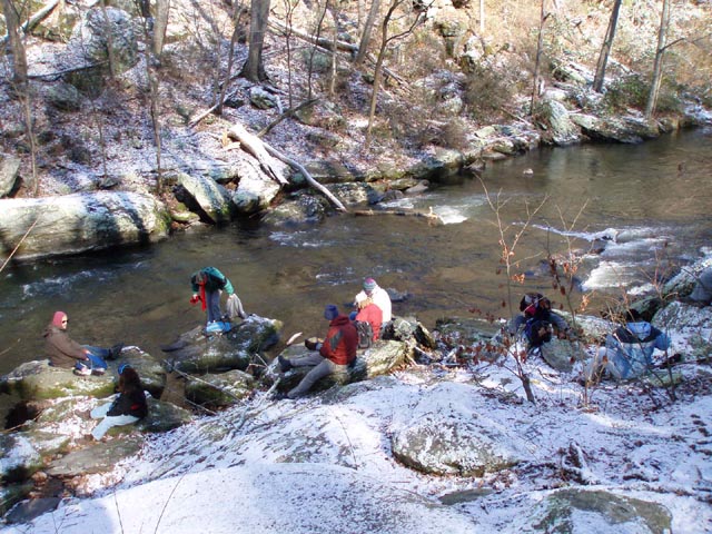
|
|
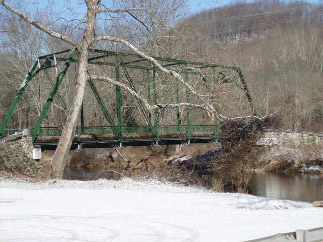
Bear left at the junction of Gunpowder South trail. Cross a stream at about 0.10 miles. The white blazed Gunpwder South Trail follows the river upstream. Come to Masemore Rd and the oldest steel bridge in MD (Circa 18XX) at another 0.42 miles. Cross Masemore Rd and continue upstream, soon passing blue-blazed Highland Tr on your left. In another 0.58 miles cross Falls Rd and almost immediately climb steeply for 40-50 yards to avoid a blowout of the bank. Quickly descend back to the river. Shortly after you descend to the river you will come to a pretty long rock field. At this location there are some nice big rocks sticking out into the Gunpowder. This is about the best spot for lunch on this part of the river. After lunch, continue upstream. Rely on the white blazes since there is little sign of a trail here. Shortly after the rock field a fisherman�s path will continue along the bank of the river but the Gunpowder South Trail will bear to left and proceeds to climb up a hill. At 0.79 miles from the crossing of Falls Rd it will again bear right and follow the river, but at a higher elevation for a while, to Pretty Boy Dam (Taking this out and back detour will add about 1 mile to the trip.) At this junction bear left onto blue-blazed Highland Tr. It flattens out on an old woods road. Cross Falls Rd again at about 0.23 miles from the last trail junction. Pass through a high voltage power line swath in another 0.50 miles. Descend to a small stream and follow it to its headwaters. Cross the stream and climb a short hill. Descend along another old road to the junction with Gunpowder South Tr (0.0.47 miles from crossing the power line swath. Turn Right and retrace your earlier steps crossing Masemore Rd and the bridge over a run. At the point where the trail reaches another stream and turns up hill (You came down this trail earlier) there are two options. You can either follow the white-blazed Gunpowder South Tr, passing the junction of previously traveled Mingo Branch Tr on the right, back to the restrooms and from there take a paved walk back to the cars or follow my preferred option to stay along the river for a bit longer as follows. Cross the stream and follow an unmarked fisherman�s trail (Shown as red on the map) that follows the river downstream. Just before a sharp bend in the river you�ll have to climb a bit up the bank and follow an extremely narrow footpath through some Hemlocks. Descend again to the fisherman�s trail on the other side of the bend. There may be one or two blow-downs to negotiate after your descent. The trail ends at the confluence of Mingo Branch and the Gunpowder. Crossing the branch usually is not a challenge. After you cross walk towards an impressive stand of evergreens with picnic tables and lantern poles under its canopy. There is no trail here but just keep walking towards the evergreens. This is Camp Wood. Follow the old road to your right out of the woods, up the hill and behind the restrooms (closed in the winter). Follow the paved path back to the parking lot. Printable/Downloadable Directions and Trail Notes _____________________________________
_____________________________________ Name: Pete Fleszar Hike: Gunpowder Falls-West Circuit Date: 01/18/14 Rating: 4
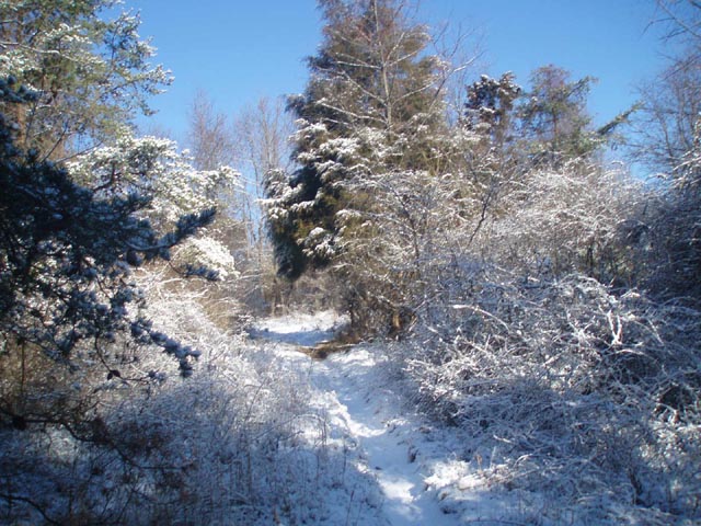
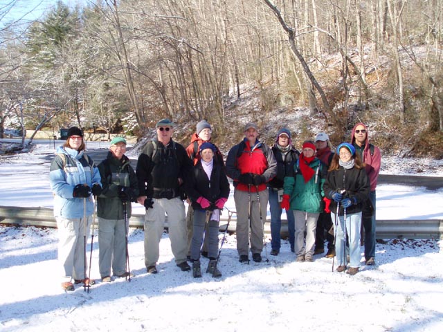
Critique: I wound up here exactly because "days are short, weather conditions are less than desirable [at first choice exploration opportunities in the Tiadaghton] and the urge to get out into the woods is overwhelming." Hike was as described - except the blazed route just south of Masemore Rd crosses not on a bridge, but on askew stepping stones (outbound water went over my boots here). (The bridge has obviously been removed.) The scenic highlight (and trickiest treadway) for me was the passage along the river above Falls Rd. I did continued out a bit on the trail towards Prettyboy Reservoir, but there was a multi-stemmed chain saw blowdown in the 2nd hollow that I didn't want to navigate twice so I turned around. With a skiff of snow on the ground, as they say in western PA things were a bit "slippy" so I stayed on the Gunpowder South trail for the last leg of the return rather than attempt the lower fisherman trail. For the non-local a few notes about the trailhead might be in order. The last half mile or so of Bunker Hill Rd is a bit rough, possibly not winter maintained although no sign said that. There is an alternative pull off area where the hike re-crosses Bunker Hill Rd on top of the hill, almost underneath I-83 by the sign for the archery range. In PA one expects a large State Park parking lot to have a map kiosk and a functioning restroom. This new parking lot at the bottom of the hill despite its size and crowded nature on a weekend morning had neither. In fact there are no trail signs at all. It was only on the return that I saw the restroom building that clearly cost the taxpayers of MD a pretty penny - with sign "Closed for Winter". The paved path back to the parking lot was long enough to obscure visibility, pine needle covered and totally unsigned behind a nondescript gate so it was evident why I had missed it. (There is now a continuation of the Bunker Hill Trail before you reach the rest rooms that leads you more directly back to the parking lot. BTW, there is now a 4X4 post with a blue blaze marking that trail at the parking lot.) Hereford also appears devoid of the normal highway commercial establishments as well. Nor is there a welcome center on I-83 southbound at the state line. If driving some distance coming from the north to this venue, get off at Shrewsbury PA for a bodily function break.
_____________________________________
Name: Bruce Hike: Gun Powder Falls-West Date: 07/04/13 Rating: 4
Critique: I did the Gunpowder Falls west loop on the morning of the 4th of July. Overall the trail notes are fine. A couple of comments. Starting point, there is not a "no bikes" sign but the trail start is fairly obvious across bunker hill rd coming back up from the parking lot on the left as you come out the way you entered. The latrines in the archery range are not locked. It looks like someone broke into them. The trail leaving the area identified as the rock area is overgrown, but obvious if you stay along the river. I did not go up the dam because it was getting hot, so I stuck to the base route. When I got back to the bridge, I decided to crossed the bridge on Masemore Rd walked .5 miles to Bunker Hill Rd and took a right to head back to the parking lot about .75 miles. My mistake was forgetting that I would need to cross the river! The water is pretty cold for July, but it only came up to mid thigh and my dog had to swim, but it really cooled him off. I saw a couple of joggers, another group of 4 hikers and quite a few fly fisherman up in the rocky area. Overall a good hike. _____________________________________
Name:
Adventure Runner
Hike: Gunpowder Falls West (Hereford Area) _____________________________________ Name: Jim
Hike: Gunpowder Falls West _____________________________________ Name: Bumpkin
Hike: Gunpowder West Circuit _____________________________________ Name: Gene
Hike: Gunpowder Falls West Circuit _____________________________________
Name: Mike Hike:
Gunpowder Falls West Circuit _____________________________________ |
|
|