|
Pole Steeple Circuit |
|
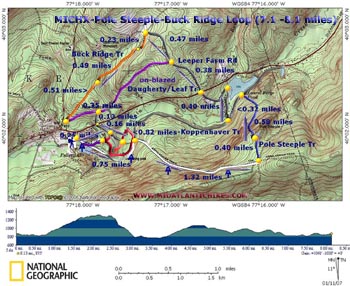
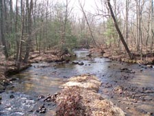
Description: The PATC hiking guide �Circuit Hikes of WV, VA, MD and PA describes a short circuit hike in this area. I�ve added a little road walking and some little used trails to make this a nice 7.5 mile trek of moderate difficulty. With just a little more road walking you can hookup with the Buck Ridge trail and make it a 8.1 mile trek. Main focal points are the halfway point of the AT, Pole Steeple and Mountain Creek. Flora varies from swamp type flowers such as Marsh Marigolds sheltered by Hemlocks to more mountainous species such as Mountain Laurel and Dogwood under a canopy of Hardwoods. Hike starts at the bathrooms near Fuller Lake. |
| ________________________________________ |
Zipped National Geographic. TOPO! GPS and Universal GPX Files |
Trail Notes: Trail Change - The Mountain Club of Maryland has rerouted the Pole Steeple Trail. Follow these instructions! From the parking lot follow the trail past the rest rooms and Fuller Lake (East). The trail becomes a gravel bike road (Railroad Bed Rd). In about 0.75 miles from the parking lot turn right onto the white-blazed Appalachian trail.
In 0.6 miles or so from the turn off come to the post marking the exact halfway point of the AT (This has now been relocated to reflect recent relocations of the trail.). Now you can tell your friends you walked to the halfway point of the AT!!!
In another 0.72 miles come to the intersection of blue-blazed Pole Steeple and Old Forge Trails on the left. Old logs block the Old Forge Tr. Take the far left trail to go to Pole Steeple.
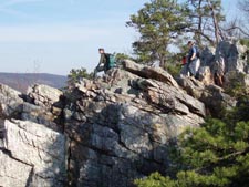
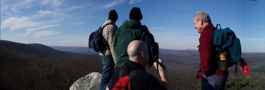
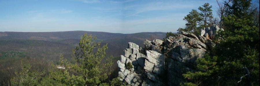
In 0.40 miles the trail splits. Take the right fork and climb up to the top of Pole Steeple for a view of Laurel Forge Pond and the entire valley.
You have two options here. You can either shimmy down the crack between the two outcrops (See photo) or return to the main trail and turn right to regain Pole Steeple Trail. Follow the trail down to Railroad Bed Rd in about 0.58 miles.
Turn left on the road. Pass a spring flowing through PVC pipe on your left and the pond on your right (currently drained � 12/07). |
|
Turn right and cross a wood bridge in about 0.32 miles. Turn right again onto gravel Ice House Rd. In about 0.40 miles turn left onto a driveway which leads to a YMCA camp. As you enter the main camp stay to the right on the road until you reach Pine Grove Rd.
Cross Pine Grove Rd.
To do the 7.5 mile loop: Walk up Leeper Farm Rd. for 0.38 miles. Look for a trail on your left behind an earthen bearm. This is unsigned Daugherty Trail. It is becoming increasingly difficult to find. Turn left here.
In about 0.6 miles cross Iron Run and in another 0.2 miles follow a gravel road around a clump of trees and pick up the trail on the other side. In 0.1 miles come to yet another gravel road. Turn left here and follow it to Pine Grove Rd (0.1 miles).
Cross Pine Grove Rd. and follow a forest road to a fork. Take the left fork. In 0.16 miles come to the junction with red blazed Kopenhaver Trail. (The park map says it�s yellow. Must be an old map!) Bear sharp left at the split and follow it down to Mountain Creek. In route you�ll cross through a swamp on some old bridges. The trail loops around through Hemlocks and Pines and returns to the picnic area via a bridge over Tom�s Run. Walk through the picnic area to get back to the parking lot.
To complete the 8.1 mile loop: Continue up Leeper Farm Rd, by-passing the Daugherty Tr. Descend slightly and in 0.47 miles turn left onto signed and orange blazed Buck Ridge Tr. This starts as a footpath but in 0.23 miles the trail merges into a nice, grassy jeep road that comes in from the right. In 0.49 miles pass an obvious but unmarked trail on the left. (This is a shortcut should you desire to shorten your hike.) Continue straight on Buck Ridge trail and in 0.51 miles arrive at its terminus on the Daugherty Tr. You can see Rt233 to the right. Make a hard left onto the Daugherty Tr and walk through an old Explorers Club Camp. In 0.35 miles from the last trail junction arrive at a 4X intersection of jeep roads. To the left is the shortcut mentioned earlier. Turn right, descending to Pine Grove Rd and follow the rest of the trail notes for the 7.5 mile trek.
Critique this outing! ________________________________________
________________________________________
Name: Danny H
Hike: Pole Steeple Circuit ________________________________________
Name: Hard Corey
Hike: Pole Steeple Circuit ________________________________________
Name: shuntphl
Hike: Pole Steeple ________________________________________ |
|
|