|
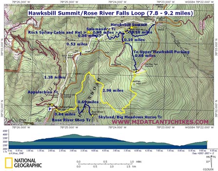
Hawksbill Summit/Rose River Falls Loop |
|
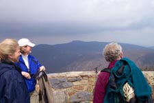
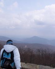
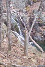
Description: This is a moderate 7.8 - 9.2 mile (includes a side trip to Rose River Falls) circuit visiting Hawksbill Summit, the highest point in SNP at 4050 feet elevation. There are several minor vistas along the AT before you reach this point, especially along the segment that passes under Franklin Cliffs. While the Salamander Trail and the Upper Hawksbill Parking Spur Trail might see a lot of foot travel during prime hiking season the 3 miles of the Skyland/Big Meadows Horse Trail will provide you with some degree of solitude. The hike down to the Rose River Falls is highly recommended especially after a wet winter. There is a lower second falls that requires a tricky bushwhack down to the river.
If in search of a little more mileage, elevation gain and pretty streams with chutes and falls add the rest of the Rose River Loop Tr, Hogcamp Tr and Rose River Fire Road as shown on the Rose River/Dark Hollow Circuit map. This will add a mile and about another 200 feet of elevation gain to the trek.
|
|
________________________________________ |
Zipped National Geographic. TOPO! GPS and Universal GPX Files |
Trail Notes: All trails are blazed. Trail junctions are clearly marked with concrete posts. From the parking lot begin walking back out to Skyline Drive. You'll see a gravel road paralleling the parking area on the left. Descend to it a pick up the white blazed AT heading north. Check out several trailside vistas as you pass under Franklin Cliffs. In about 1.38 miles pass by Spitler Knob Overlook and then a blue blazed spur trail on the right which leads to parking fro the Rock Spring Cabin. Continue on the AT and in another 0.53 miles pass a blue blazed trail on the left which leads to Rock Spring Cabin and hut. A service road on the right leads to Skyline Drive. Stay on the AT. In 0.28 miles come to the junction with the blue blazed Salamander Tr. Turn right onto it as it switchbacks up for 0.65 miles. The trail splits. If you take the right fork soon step onto a gravel road. Turn left and follow the road up to Byrds Nest # 2. Hawksbill Summit is another 50 yards up the trail. After taking in the views proceed down the road. Just behind the Byrds Nest pass a blue blazed trail on the left that leads to Hawksbill Gap. Stay on the road. In about 0.2 miles come to another concrete post. Turn left onto the blue blazed spur trail that will take you to the Upper Hawksbill parking area in 0.7 miles. |
|
Cross Skyline drive and turn right (south) in a few yards come to a spur trail that leads to the Skyland/Big Meadows Horse Tr. In a few yards arrive at the junction with same (yellow blazes). Turn right onto it. For the next 2.95 miles you will be hiking on a pretty wide and smooth trail. There are a few rocky sections and some short climbs but route is generally downhill. After 2.95 miles from joining the horse trail come to the junction with blue blazed Rose River loop Tr. turn left onto it and descend, via switchbacks, for about 0.7 miles to the top of Rose River Falls. A tricky bushwhack leads you to the base of the lower falls. The trail continues down river but to complete this hike as described turn around and retrace your steps back up to the junction with the horse trail. Turn left onto the horse trail and in 0.44 miles arrive at the Rose River Fire Road. From here you can see Skyline Drive and the Fishers Gap Overlook Parking Area to the right. Turn right and return to your car.
Printable/Downloadable Directions and Trail Notes ________________________________________ ________________________________________
Name: Cindy
Hike: Hawksbill Summit/Rose River Falls Loop ________________________________________
Name:
ElliottsKnob
Hike:
Hawksbill Loop ________________________________________
Name: Michele P
Hike:
Hawksbill Summit/Rose River Falls ________________________________________
Name: ElliottsKnob
Hike:
Hawksbill Summit/Rose River Falls ________________________________________ |
|
|