| Michaux SF - Glatfelter Area-1 |
|
|
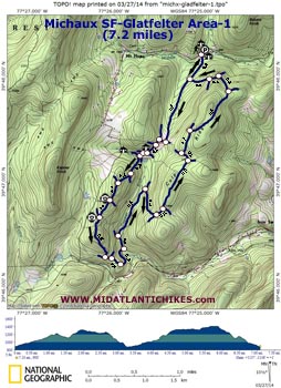
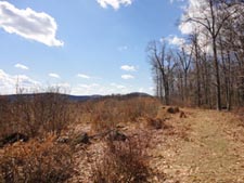
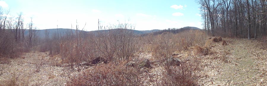
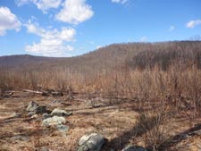
Description: On 05/24/2010 �the Conservation Fund announced the transfer of the 2,500-acre Tree Farm #1 property in Hamiltonban Township, Adams County, to the Pennsylvania Department of Conservation and Natural Resources (DCNR), completing a two-year partnership involving federal, state, and local governments, private organizations and the citizens of Adams County. The property is now part of the Michaux State Forest.� It contains several miles of well maintained logging roads open to hiking. The Forest Service has yet to develop a trail map for the area. The following 7.2 mile moderate hike is based on GPS data obtained on 03/16/14 while hiking with Wooly Bully, Single Malt and the Mad Hatter. I tried to collect a waypoint for every road junction we came across. Still there may be some lesser traveled roads that are not easily seen. Take this map, trail notes and a compass with you and you should do alright. The hike begins at the Strawberry Hill Preserve (a nice hiking venue in its own right!) on the south side of Mount Hope Road. |
|
________________________________________ |
Zipped National Geographic TOPO! GPS and Universal GPX Files |
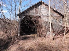
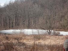
Trail Notes: As you face the pine trees behind the parking lot turn right and walk out to a grassy area. Turn left at the edge of the pines and cross Middle Creek on a stout bridge. The Middle Creek Trail, a part of the preserve, bears to the right. Stay straight, walking around the steel forest gate. In 0.3 miles pass a road on the left. This will be your return route. The road continues to climb gradually in a southerly direction for another 0.7 miles. Turn right at a 4-way intersection. In less then 0.1 miles this road will also turn south. Here a fainter road will come in from the right and yet another one, also from the right, in a few more steps. You�ll soon arrive at an old barn at the beginning of a hollow. You�ll see a pond to the left. This is probably the trickiest part as old logging roads go off in almost every direction. Bear right, keeping the pond on your left until you are past it. The trail that you are on will climb a short hill, pass a well maintained cabin and end at a forest gate on Mount Hope Road. You don�t want to go this way. Turn left at the bottom of the hill instead. This road splits almost immediately with the trail on the left staying low and following the bank of the pond. Bear slightly right here climbing gradually up a wooded hill. Bear right at a fork in another 0.3 miles and in 0.2 miles arrive at a clearing with what appears to be a game feeder on the right. A trail, also to the right, leads to Mount Hope Road. Continue straight here and in 0.3 miles arrive at a clear cut area that provides a view of Culp Ridge to the east. You will be there in a couple of miles. You might see another road to the left. Continue straight. Arrive at a westerly view including Kepner Knob in another 0.2 miles. The last logging road leading to Mount Hope Road is on your right. The �main� logging road descends through mature forest for 0.5 miles to a three way intersection. Turn left here and in a few steps pass another road on the left. There was a tree across it when we did the hike. Ignore it and continue straight out to a gas pipeline right of way. Turn left onto it and descend but only for a few steps. The logging road will veer off to the left. Follow it for 0.3 miles and cross Copper Run. Immediately turn left, joining another road and cross the run again. |
|
The road will closely follow the stream, passing a road to the left in 0.2 miles and then crossing the stream again, this time over a culvert. In 0.6 miles from the last intersection make a sharp right hand turn and climb for 0.4 miles to another road, this one along the top of Culp Ridge. Turn left and in 0.1 miles reach the ridge�s crest. There will be a road to the right. Continue straight (left). The road passes through forests all going through different stages of recovery. In 0.6 miles turn left at a three way junction but in 0.1 miles turn right again if you want to continue the ridge walk. Reach another fork in 0.3 miles. Going left will get you back to the starting point a little faster but going straight (right) will bring you some broken pastoral views and a glimpse of Sugar Loaf to the east, a knob that rises out of the valley all by itself. If taking the more scenic route arrive at another junction in 0.6 miles. Turn left and in another 0.2 miles turn left again. Here you begin to descend from the ridge. Pass the previously mentioned shortcut on the left in 0.1 miles and then, in another 0.2 miles arrive back at the original road you started on. Turn right and retrace your initial steps back to your vehicle.
________________________________________
________________________________________ |
|
|