|
Colonel Denning SP-Flat Rock Circuit |
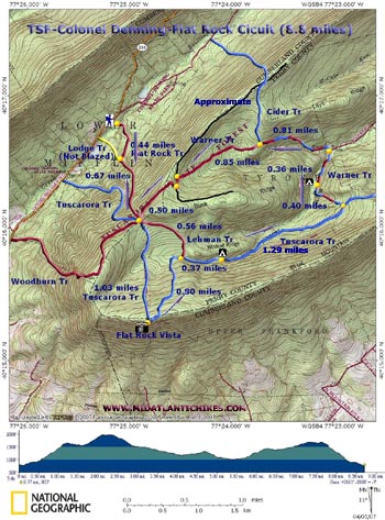
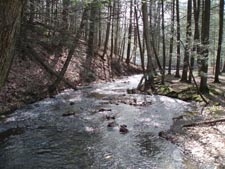
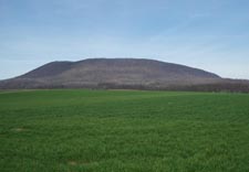
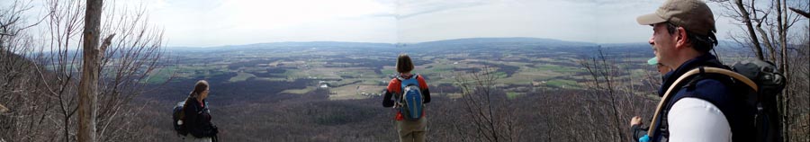
| Description: You don't hear much about hikes in the Tuscarora State Forest but there are some nice ones. This particular one, in my opinion, is a little hidden gem. It's rated strenuous and should not be attempted by anyone with health issues or is not in at least moderate shape. The overall elevation change is about 4200 feet over 8.8 miles. In the first 2 miles you will climb approximately 1500 feet, some of it is extremely steep and rocky. The reward at the top is worth it. There you will find a sweeping view of Cumberland valley. After a descent on the Tuscarora Tr through a seemingly never ending rock field you will be greeted by a succession of old jeep roads. Most are in good shape but a few may be wet and/or rocky. Portions of the rest of the loop will closely follow Wildcat and Trout Runs. We were surprised to find some really nice camping areas tucked away under the Hemlocks on the benches of the streams. The climb out of the hollow is not without cost. You will climb a total of 800 feet before you return to the junction of 6 trails referred to as the Wagon Wheel which you passed through on the way to the vista earlier. |
|
Only the initial 0.5 miles of this is steep. At times you
may catch glimpses of Blue Mt and then Buck Ridge as you
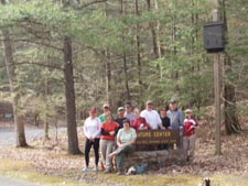
ascend, especially when the leaves are off. The hike starts at the Nature Center Pavilion and amphitheatre. Follow the park signs. ______________________________________ |
Zipped National Geographic. TOPO! GPS and Universal GPX Files |
Trail Notes: There are some maps available at the park office. They have some errors. The park map itself shows the trail starting in the campground. You want to start at the Nature Center pavilion just before crossing into the campground. There is loads of parking. On the photo-copied map note that the Wildcat Tr has been merged into the Warner Tr. All trails are signed at the junctions and road crossings and are, for the most part, adequately blazed. From the amphitheater bear left and cross Doubling Gap Run on a bridge. Climb a steep set of steps. A equally steep spur trail from the campground comes in from the left. Follow a wide red blazed dirt road. In 0.4 miles another dirt road comes in from the right. This leads to a private lodge in the gap. Continue up the dirt road and around a spring house. The trail disintegrates into a steep rocky footpath as it leaves the state park here. In another 0.67 miles reach the Wagon Wheel, the junction of six trails. Continue straight on the blue blazed Tuscarora Tr. Soon pass a shelter on the left. Descend slightly and cross over the boggy headwaters of Wildcat Run using a series of rock bridges and boardwalk. Climb steeply to the top of Blue Mountain and the Flat Rock Vista (1.03 miles from the Wagon Wheel). After taking in the breathtaking views of the Cumberland valley return to the Tuscarora and cross the crest of the mountain. Descend through a rock field to the junction of red blazed Lehman Tr on the left in 0.80 miles. The Tuscarora Tr soon joins an old jeep trail and begins following pretty Wildcat Run. Keep and eye out on the left for some good camping areas in about 0.37 miles. Shortly after this the run bears away to the left as it descends down the hollow. The Tuscarora Tr stays at the same elevation. In another 1.29 miles turn left onto red and the blue blazed Warner Tr (This first segment down to the Wildcat Run crossing was formerly named the Wildcat Tr and is still called that on some maps.) |
|
This is a very nice trail and you will soon find
yourself paralleling Wildcat Run. More good camping
spots can be found at about 0.36 miles from the last
trail junction. Cross Wildcat Run, MCCabe Rd and Trout
Run in another 0.36 miles.
Climb steeply for 0.81 miles. At the top the blue blazed Cider Tr will go to the right. The Warner Tr will continue straight,
now with only red blazes. Pass through a deer exclosure. You
will then descend slightly before beginning a long gradual climb
to a gravel haul road reaching it in 0.85 miles from the Cider
Tr junction. The trail follows another deer exclosure on the
right along part of this section. Turn left onto the haul road
but in a few yards, at a turn around area, turn right onto the
signed continuation of the Warner Tr. In another 0.50 miles of
easy walking with partial views of Doubling Gap to the right
arrive back at the Wagon Wheel. Retrace your original 1.1 miles
back to the vehicles.
Printable/Downloadable Trail Notes ______________________________________
______________________________________ Outing Critiques
Name: Jeff
Photo ______________________________________
Name: Chris
Hike: Colonel Denning State Park ______________________________________ |
|
|