|
Chief Benge Scout Trail-West Shuttle |
|
|
Description: Chief Robert Benge was a half-breed son of a Scottish born trader who lived among the Cherokee. He was much larger than the average native, was a speedy runner and considered �un-trackable�. His brilliant red hair caused him to stand out among his brethren. He was considered responsible for over 100 raids against the white settlers although some of them were actually performed by other parties. Needless to say his reputation preceded him. Benge was eventually killed in an ambush set up by Virginia militia and his scalp sent to the governor as proof of his demise. Upon his death and the earlier killing of the tribe�s chief the raids stopped. This trail is named in his honor (???). Google Maps Custom Driving Directions to Bark Camp Day Use Area Google Maps Custom Driving Directions from Bsrk Csmp R.A. to High Knob Trailhead.
Both the Bark Camp Lake and High Knob Recreation Areas are fee areas - $3.00/car. |
|
The official western Chief Benge Scout Trailhead is located at the High Knob Tower parking lot but the tower burned down in 2006. It is currently being rebuilt and the access road is closed to the public. It is slated to re-open lin July, 2014. Once the tower opens you can start there. Add about 1.5 miles to the following description.
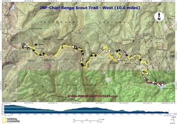
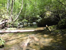
This hike starts at the south-east corner of the day use parking area at a service road across from some restrooms. There is a brass plaque honoring the folks who constructed the High Knob Recreation Area. It ends 10.6 miles to the east at the Bark Camp Picnic Area. There are fourteen fords through four different drainages. During periods of high water your boots will definitely get wet. Be prepared for this. ________________________________________ |
|
Printable/Downloadable Map (11X17 best) Zipped National Geographic. TOPO! GPS and Universal GPX Files |
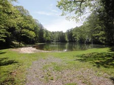
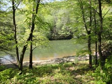
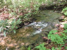
Trail Notes: Proceed down the service road towards the lake. In 0.1 miles the yellow blazed Chief Benge Scout Trail will join from the left. Continue on the service road for just a few more steps and turn left to follow the trail around the north side of the lake. Pass a view of the lake and then the dam before descending to the first of fourteen fords in 0.5 miles after leaving the service road. Initially you will be following Stony Creek.
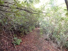
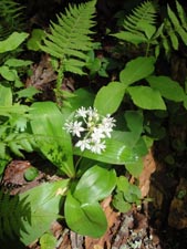
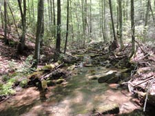
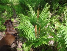
The trail is relatively easy to follow but you might experience several blowdowns along the way. The valley is very narrow for the first 3.0 miles making it easy for trees to fall. It�s difficult for the all volunteer maintenance crews to stay on top of the situation. With these issues put aside you will enjoy a lush environment full of rhododendron tunnels, wildflowers, ferns and giant moss covered boulders. In the early spring expect to see trillium and May apples. Later spring brings wild geraniums, white clintonia, a wide array of violets and cinnamon fern. In the summer expect to find black cohosh, baneberry, sweet cicely and foam flower. Ford the creek again in 0.4 miles and then again in a mere 0.1 miles. The valley widens significantly after this last crossing and the going becomes much easier for the next 1.5 miles. About halfway along this stretch you�ll pass a wide and flat area along the stream suitable for camping. |
|
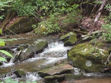
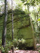
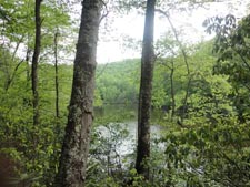
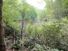
The creek then flows through a culvert under Forest Road 704. Climb a set of steps to the road and cross it, jogging to the left, and descend to a campsite on another set of steps. Ford the creek again in 0.2 miles and then once more in another 0.3 miles. Reach what I call a trail blowout shortly after this last crossing. As of this writing there in a large fallen log lying in a diagonal across the trail with a steep muddy bank on the other side. After negotiating this blockage you�ll be standing in the creek itself. As you look around you might notice the grotto-esque nature of this bend in the creek. Abbey, my dog, and I enjoyed relaxing here for a bit before continuing. �Splash-whack� down the stream. As it goes around the bend you�ll see a shear rock face to your right. This is where the trail used to be. In just a few more steps climb up the bank on the right to pick up the continuation of the trail. The trail continues on an old grade, crossing the creek three more times, the first in 0.1 miles and then nearly back to back crossings in another 0.5 miles. Here the trail climbs, steeply at first, to reach yet another grade and curves sharply to the left (north) before descending to the Bark Camp Branch drainage in 0.7 miles. Although smaller than Stony Creek it is equal to it in its beauty. Sadly the trail does not along its banks long enough. After two quick crossings the trail veers away from it to climb through a typical Appalachian hardwood forest of oak, maple, poplar and beech with an understory of blueberry and ferns. In 0.8 miles turn left onto a dirt road and in a few steps cross a gravel service road that leads to some weather data collecting equipment you may have seen to your right through the trees during your approach. The trail turns right to parallel the road for a bit before switchbacking up to Edith Gap. You�ll notice that the trail is blazed in both orange and yellow as the tread is shared for a while with a equestrian trail. Don�t be alarmed if you see trees with only orange blazes. In 0.9 miles cross another gravel service road at Edith Gap. Signs reassure you that you are going the right way. Descend to Little Stony Creek in 0.5 miles and immediately ford it two times. Here the ferns are denser than any where else along the hike with the majority being of the cinnamon and hay scented varieties. Cross the stream again at 0.4 miles. The trail will continue to follow the creek a bit before climbing away from it to cross another service road in 0.5 miles. Descend to Robinson Fork, fording it in 0.4 miles from the service road. The trail then passes through some boggy areas before climbing to a wide grassy/weedy road that wraps around Davey Land Ridge. Here you can settle down into an easy saunter as you �recover� while still on the move. In 1.0 miles turn right onto a signed footpath arriving at the headwaters of Bark Camp Lake in 0.2 miles. The official route of the Chief Benge Scout Trail turns right here crossing Little Stony Creek on a boardwalk. The shortest route back to the day use area is to continue straight on the unsigned and un-blazed but otherwise very obvious Lake Shore Trail. You�ll pass window views of the swamp and lake. Pass three spurs on the left that lead to the campground at 0.8, 0.3 and 0.1 miles respectively. In another 0.3 miles arrive at the Bark Camp Day Use Area. ________________________________________
________________________________________ |
|
|