|
Brown Mountain - Rockytop Loop |
|
|
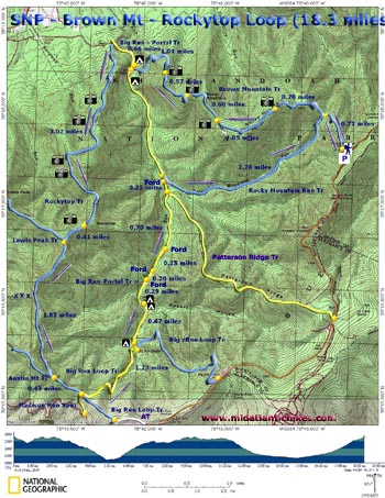
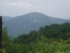
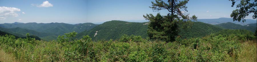
Description: This is a strenuous 18.3 mile backpack with too many vistas to count including a grand view of the Shenandoah valley and the southern most tip of Massanutten Mt. Due to the ruggedness of the terrain and availability of campsites it is described as a 2 night trip. This takes a bit of the edge off of the difficulty as you'll probably be arriving at camp early each day. There are no campsites or water sources on either the Rocky Mt/Brown Mt ridge or Rockytop. Much of this area was destroyed in a devastating forest fire in 1986. Much of it has not recovered lending the hiker some incredible views. Special Note: Google Maps and other on-line mapping programs might suggest you use old fire roads that are no longer accessible by automobile. Use a real map to confirm your route. This trailhead is at the Brown Mountain Overlook just north of Mile Post 77 on Skyline Drive. |
|
________________________________________ |
|
Zipped National Geographic. TOPO! GPS and Universal GPX Files GPS Text File for Non-TOPO! Users
|
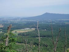
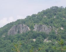
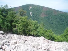
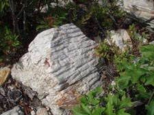
Trail Notes: All trail junctions are signed and the trails are blazed either yellow or blue. Trail Notes: From the Overlook find the break in the stone wall. This is the Brown Mountain Trailhead. From hear follow the blue blazed trail. Initially the trail passes through an open area with constant views of Rockytop and peaks and ridges beyond it. Descend into a saddle and the junction of the Rocky Mountain Run Trail on the left at 0.63 miles from the overlook. This is your return route. Continue straight and climb to the top of Rocky Mountain. The trail will switch between the ridge's northern and then southern flanks. When you first reach the top you'll pass the first of many vistas (0.99 miles from the last trail junction). After walking along the ridge top of Rocky Mountain for a while you'll descend to another slight saddle and then climb to the top of Brown Mountain. The walk along this ridge is short but you'll enjoy at least 3 more vistas not counting the ones encountered during your descent, along switchbacks, to Big Run. In 1.04 miles from the last ridge top vista arrive at a concrete post. Bearing to the left (or more straight ahead) leads you to the junction with the yellow blazed Big Run - Portal Trail. There are no markings for the initially obvious foot trail to the right. This is an unofficial trail that leads to a couple of really nice campsites. (Note: Fires are not allowed in SNP!) If these are occupied there are a few isolated small campsites about 500 yards upstream. To continue the circuit turn right onto the yellow blazed Big Run - Portal Trail and cross the bridge. For the next 3.7 miles the hike is mostly uphill. At 0.66 miles from the bridge turn left onto the signed and blue blazed Rockytop Trail. The trail is extremely steep for the first 1.5 miles and then the grade lessens. For the next 2 miles you are rewarded with grand views of the Shenandoah Valley, Massanutten Mt, the Allegheny Mountains and several adjoining peaks including Lewis Peak. Parts of the trail are overgrown while other parts are very rocky as you cross large talus rock formations. Watch for the round worm fossils in the sandstone. They appear as striations in the rock. |
|
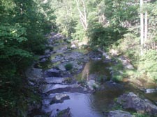
In 3.02 miles after leaving the Big Run - Portal Trail arrive at the west side of Rocky Knob and another Talus Rock Formation. This, by far, is the best view from Rockytop ridge as the scenery is framed by two tall peaks. Climb some more and in another 0.41 miles pass the junction with the Lewis Peak Trail on the right. For the rest of the day your trek will be mostly downhill. In another 1.82 miles pass the junction of the blue blazed Austin Mountain Trail on the right. In 0.43 miles bear left onto yellow blazed Big Run Loop Trail. In 1.23 miles arrive at the southern terminus of the Big Run - Portal Trail (also yellow blazed). Turn left here. In about 100 yards there is an old campsite to the left. Although a little overgrown you can fit several tents there. If you have the energy there is another really nice sight 0.67 miles further downstream and on the right. This is probably the best place to camp in the entire valley. From this last campsite continue downstream. You'll ford Big Run three times. These may be wades during periods of high water. You'll also ford Rocky Mountain Run once. In 0.7 miles after the last ford of Big Run pass the junction of yellow blazed Patterson Ridge Trail on the right. In 0.25 miles make the ford of Rocky Mountain Run and soon make a hard right onto blue blazed Rocky Mountain Run Tr. In another 0.71 miles arrive at a nice swimming hole (Not shown on the map but easy to find). There is a campsite on the other side big enough for one or 2 tents. The climb to this point has been quite gradual. It will become slightly steeper for the next mile and become more severe over the last mile. You will be aided near the top by some much appreciated switchbacks. In 2.08 miles from the last swimming hole reach the junction with Brown Mountain Tr. Turn right here and retrace your initial steps back to your cars. ________________________________________
________________________________________
Name: Sean
Morrison
Hike: Brown Mountain - Rockytop Loop ________________________________________ Name: Larry and Krysten Hike: Brown Mountain-Rockytop Loop Dates: 07/09-11/13 Rating: 5
Critique: What a beautiful loop trail!! The grass, thorns and brush had been recently trimmed and there were no fallen trees to deal with. Even with the trees in full leaf, many of the vistas provided sweeping views. This is a perfect time of the year to "dine" on wild blueberries, black raspberries and blackberries. We saw grouse, a rabbit, and a small buck who decided to follow us for a while. We encountered a day hiker who had seen a black bear. Heed the warning about the lack of water and campsites on the slopes and tops of the two mountains. On a note of caution, be sure to apply tick repellant. I picked off 3 wood ticks and unfortunately ended up with 2 embedded deer ticks (yes, I am now taking antibiotics). This will be an unbelievable hike when the leaves are turning or when they have dropped. Crossing the �large talus rock formations� will be quite tricky if the rocks are wet or icy, and being on the top could be very �exciting� during a thunderstorm. ________________________________________
Name: Kathryn
Hike: Brown Mountain-Rockytop Loop ________________________________________
Name: Unknown
Hike: Brown Mountain - Rockytop Loop ________________________________________
Name: Keith
Selbo
Hike: Brown Mountain - Rocky Top Loop ________________________________________
Name: Cham
Green
Hike: Brown Mtn Rocky Top |
|
|