| Big Mountain-Pine Tree Vista Circuit |
|
|
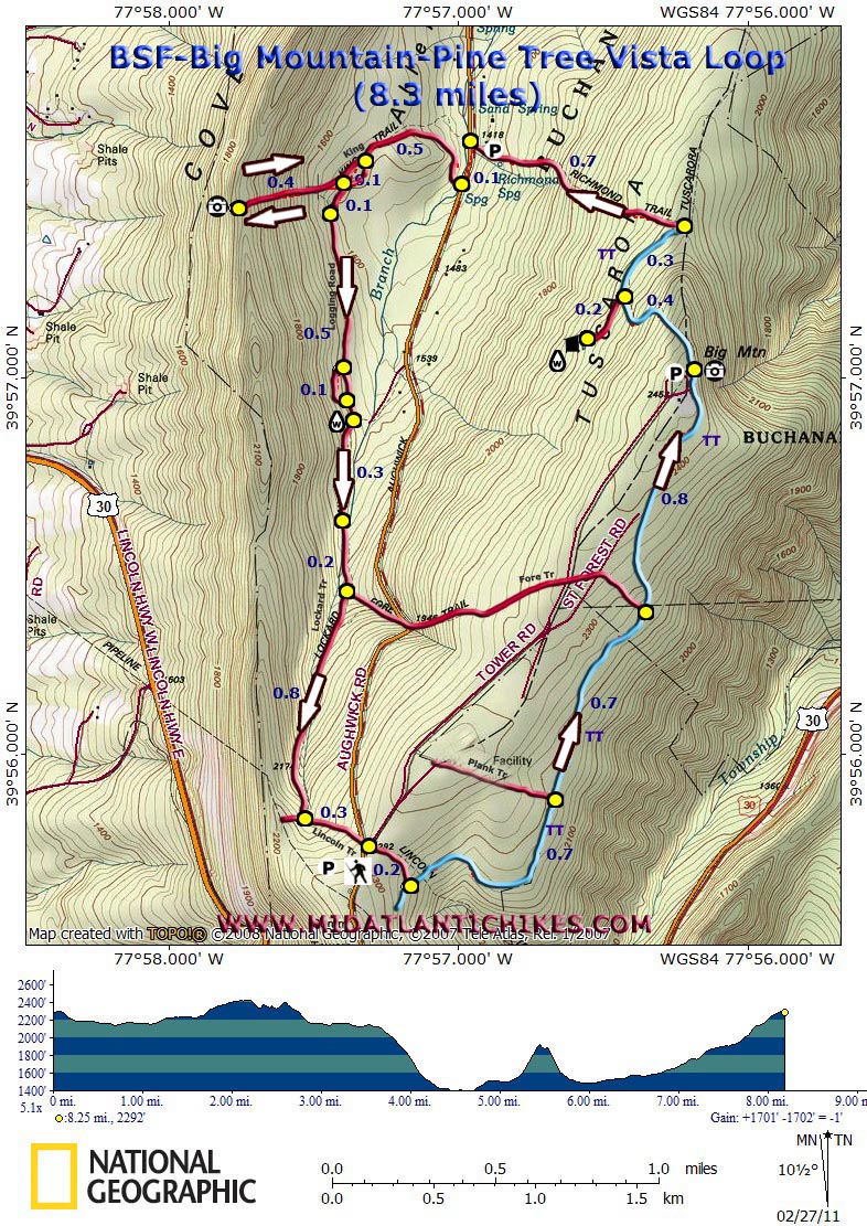
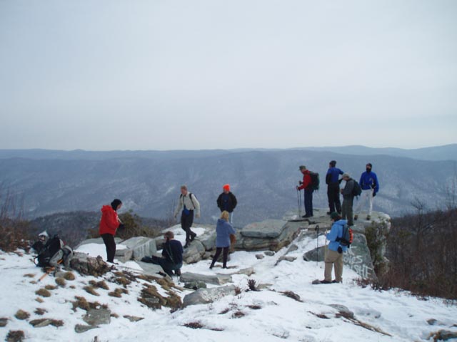
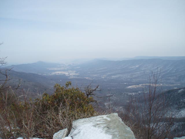
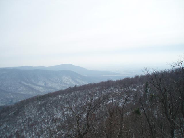
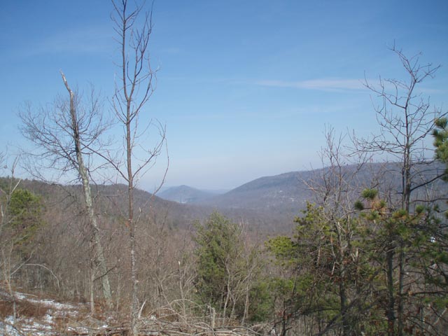
Description: Thanks to Ed Stobenaue for showing us this hike first hand. Big Mountain is a summit on Tuscarora Mountain, a long ridge that divides Allens Valley to the west from Path Valley to the east. Although you can drive to this vista it is much more rewarding, and not all that difficult, to hike to it. Add to it a challenging 400-500 foot climb over 0.4 miles to a grand view of Allens Valley, seeing north as far as Cowans Gap, and a relaxing hike on the Lockard trail encased in Mountain Laurel and Hemlocks and you have yourself a pretty respectable day hike. We give this hike a strenuous rating mostly because of the steep climb to the Pine Tree Vista. If this is excluded from the trek, reduce the mileage by 0.8 miles and reclassify it as moderate. |
|
Goolge Maps Custom Driving Directions The hike starts at the parking area at the intersection of Augwhick and Tower Roads. ________________________________________ |
Zipped National Geographic TOPO! GPS and Universal GPX Files |
Trail Notes: Most (but not all) trail junctions are signed. Trails are still obvious. Only the Tuscarora Trail (TT) is blazed (blue).
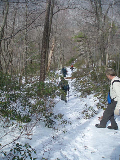
From the parking lot walk around the yellow steel gate and follow an old logging road (Lincoln Trail) for 0.2 miles. As it curves to the left the TT comes in from the right and the road begins to carry its blue blazes. The walking here is pretty flat and open. In 0.7 miles another road, the Plank Trail, comes in from the left. The road curves to the left in 0.7 more miles becoming the Fore Trail. Leave the road to the right here on a rocky footpath as you continue to follow the blue blazes. There is a gradual climb here but the rocks are more of an issue than the elevation change. Arrive at the end of Tower Road and the Big Mountain vista in 0.8 more miles.
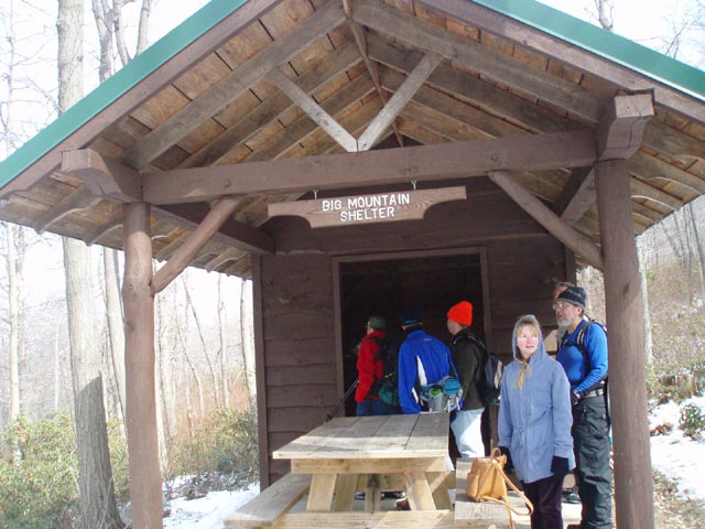
After taking in the views continue NOBO on the TT as you pass the footers for the old tower. The footpath will end at a jeep road. Turn right and switchback down to another jeep road. To visit the Big Mountain Shelter turn left and walk for 0.2 miles to a turn off.
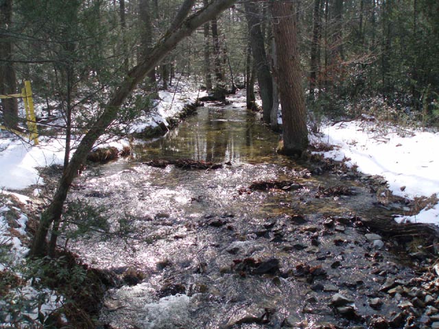
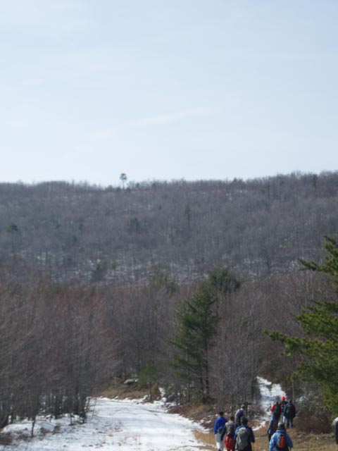
After another short break return to the previous junction and either continue on the jeep road or re-join the TT which parallels it before rejoining it at the next trail junction. In 0.3 miles turn left onto the Richmond Trail and descend steeply for 0.7 miles to Augwhick Road. Turn left onto it for 0.1 miles then turn right onto the King Trail. Cross the creek on a bridge and turn right onto a logging road. In 0.5 miles the King Trail leaves the road on the right. Follow it. At this point you can see the single pine tree on the ridge that you are heading for. Soon pass a fork in the trail. You will use the left fork on your descent. Begin a steep climb. In 0.4 miles, just before the Pine tree bear to the left in front of some tangled fallen trees to get to the edge. Here you will get a rewarding view of Allens Valley, Cowans Gap and the park lake. |
|
Retrace your steps, bearing right at the fork and return to the logging road. Turn right, passing a piped spring in 0.1 miles on the right. The logging road continues for 0.5 miles. Here it becomes wet and overgrown. If it is impassable there is a by-pass trail to the right that parallels it. If you take this route be careful to maintain visual contact with the logging road so you can return to it near its end. The road will reduce to a foot path and soon join the Lockard Trail which comes in from the left. Here you will be climbing on a very gradual grade. In 0.3 miles the grade splits. Stay straight (left) to stay on trail. In another 0.2 miles the Fore Trail also comes in from the right. The Lockard Trail ends in 0.8 miles at the Lincoln Trail. Turn left onto it and in 0.3 miles cross Augwhick and then Tower Road to return to your vehicle.
________________________________________
________________________________________ Outing Critiques Name: Travisw Hike: Big Mountain/Pine Tree Vista Date: 05/02/15 Rating: 4.4
Critique:
Started on map off tower road
at the top of Big Mtn so I can understand how starting down on
Aughwick road and climbing 900' would definitely get the ole
lungs and heart working. I am surprised to see this trail, as
steep as it is, is very well maintained and little to no wash
out all things considered. I took my 19 yr old son this day as
we had to sort some stuff out. We saw porcupine, turkey, deer
and hawks. Big moutain overlook well worth it despite the
element of graffiti. This overlook is most likely beautiful in
any season. Only have a few items to watch out for. The old
logging road, easy to follow but once it's ready to enter back
into forest.....super marshy!! Need to walk up in woods to
avoid sinking in 6 or more inches at spots. The sign at the fork
for Fore trail appears to have dry rotted off tree and is is
wedged between two trees pointed wrong direction. Unfortunately
my son and I chose the wrong trail, which was Fore trail. This
trail gets to be very interpretive at spots as seems to follow a
temporary creek bed and it is super steep. The 500' climb up
Klines (Kings?) trail was not as rewarding as I thought it would
be..maybe best viewed when all leaves are off trees...this trail
as well was straight up and a heart and lung metiator. All in
all I have done all three hikes in this area listed and
absolutely loved it. Well worth it! _______________________________________
Name: Ed S. Hike: Big Mountain/Pine Tree Vista Date: 07/29/13 Rating: 5 (4 if uncountable spider webs present)
Critique: It may be odd for me to review this hike, but after reading the recent reviews it'd be a good time to revisit, especially as I'd never hiked Big Mountain in summer. I did the hike in the described CCW direction, but I started at the King trailhead, in the valley instead of atop the mountain. When I went, the trails were in much better shape than recently described. The State Forest trails (Lincoln, Plank, Richmond, King, Lockard) have all seen recent brush clearing and blowdown removal. The logging road sections have been mowed, not quite as recently as the trail clearing though. In my experience, the logging roads get mowed perhaps a few times a year; the State Forest trails get cleared no more than once a year at best. The Tuscarora Trail was also in good shape and well trodden. It is a narrow footway, and there was tall grass to go through on both sides of the Big Mountain overlook. The King-Lockard connector sees some use; though its start off the logging road is still somewhat obscure. Look for where the mowing ends or for where non-fenced-in trees appear in the middle of the logging road; the bypass is cut into a small rise above the logging road. I did some rough clearing along the rest of the bypass; so where to leave the logging skid is perhaps a bit more obvious. As to where the trail to Lockard begins, be sure to work all the way to the southeast corner of the bypassed wet area while staying within the tree line. In addition to the two overlooks and the shelter and its pond, my favorite part of the loop is the Lockard Trail, a serene wonderland for a good part of its length, through hemlocks and mountain laurel. It's a great trail for all seasons, and most of the time you can quickly forget you are closely paralleling a road. Plus, apart from the Big Mountain overlook, most likely you will experience full solitude. (Of course, that can be an issue; in the summer on a lot of the trails I was clearing spiderwebs strung across the trail which often seemed like every 20 feet or so.) The rough path to the King Trail overlook is apparent as soon as you once again see the lone pine atop the mountain. I should note that this overlook can be skipped in the summer, as it was somewhat leafed over. I hope that is merely a seasonal issue. In clearer times you can see the surprising offset in Tuscarora Mountain at Cowans Gap, along with fleeting views of the lake. Some navigation notes. (1) Except for the Tuscarora Trail, blazes are faint and infrequent. Plank and Lockard are green; Lincoln, Fore, Richmond, and King are red. (2) There is no longer a sign for the Lincoln Trail at the start though it is clear due to the yellow gate. (3) At the split of the Logging Roads at the Tuscarora Trail, make a sharp left turn. (4) Halfway between the Lincoln and Plank Trails, the Tuscarora narrows from a logging road to more a woods road. (5) The woods road that the Tuscarora Trail follows makes a 90-degree left turn at the <b>unsigned</b> junction with the Plank Trail; the Tuscarora continues straight ahead there as the narrow footpath, not further along at the Fore Trail. (6) The sign for the Richmond Trail atop the mountain does face north, so you would only see the back of the sign. However, just north of the junction is where the Tuscarora Trail rejoins the logging road, with a sign that'll be fully visible whichever way you went. From the Tuscarora sign just face south on the logging road and the Richmond Trail will be readily visible. (7) There are two Lockard/Fore Trail junctions, as they are co-aligned to cross the creek. The lower/first junction has a Fore Trail sign resting in a tree; veer left and stay on the obvious trail. The second/upper junction is in a very small clearing, veer right and make a very short descent to cross a usually dry streambed. (If you take the Fore Trail at the first junction; you'll find yourself climbing Cove Mountain on a rough unmaintained trail, and unless you are hiking all the trails in Allens Valley or want another steep climb and descent to do there's really no good reason to head up it. If you take Fore at the second junction, you'll find yourself in a narrow rock walled side-hollow and soon climb to the paved road. It can make a good shortcut between the Lockard, Gish logging, and Tuscarora Trails.) (8) The Lockard/Lincoln junction only has a sign for the Lockard Trail, but the junction will be obvious, as will the direction as the Lincoln Trail climbing Cove Mountain did not get the recent care the other way did. As for wet areas, assuming you remember the bypass, the only issue I had was immediately before the stream crossing along the Lockard Trail, for maybe 20-30 feet. In the spring there are more areas, as is clear from the mosses along the trail, but I recall these to be easy to get through. One final word. Consider an alternate start to the hike by walking up gravel Tower Rd to the Plank Trail, and take that east to the Tuscarora Trail. The distance and elevation change are basically the same, plus you get to walk past the "bowling pin," and thanks to past logging operations, you get some good views of the ridges to the east, Cumberland Valley and South Mountain, and the Bear Pond Mountains.
_______________________________________
Name: Rebecca Hike: Big Mountain/Pine Tree Vista Date: 07/05/13 Rating: 1
Critique: DO NOT go on this hike. I am an experienced hiker. I've hiked all the way up and down the east coast from Katahdin's Knife edge to Mt. LeConte in the smokies. This was the worst hike I've ever done. The first portion to the big mountain viewpoint is pleasant but it's not worth it because you can just drive there. The rest of the hike is extremely poorly maintained. I missed the sign for the Richmound trail because it's only visible coming up the mountain and not down the mountain. I hiked on the Tuscarora trail about a mile out of my way because I missed it. Then, I hiked up to try to find the viewpoint over allens valley and even with the warnings in the comments I could not find the vantage point. Most of the trail is tall grasses that are poorly maintained. I pulled several ticks off of me during the course of the outing. Finally, after failing to find the second viewpoint and after having pulled several ticks, I decided to give up on the rest of the trail and walked pack to my car up Augwick road. If you're into serious off trail hiking, this could be the right one for you. Might also be good on horse or bike. But it's completely unsuitable for a day hike, and I would recommend that they take it off the website.
_______________________________________
Name: Linda Hike: Big Mountain/Pine Tree Vista Date: 06/05/13 Rating: 2
Critique: A friend and, co-leaders of an all-women outdoors group, did this hike as a preview to see if it was suitable for the group. Between the 2 of us we probably have 30 years of hiking/outdoors experience, maybe more. I point that out to show that we are not inexperienced hikers by any means. Where to start....The trail notes on the site were just adequate. Even with them and the map, had we not had a GPS with us we would have been very lost more than once. As it was we made 3 wrong turns (following the notes) and had to backtrack each time. They could have used far more detail - i.e. Note total lack of signage and blazes at most turns; indicate that the marshy area is wide, long, deep, and that above-the-ankle waterproof boots are MUST, not just a recommendation. We were wearing boots like that and still nearly had them sucked right off of our feet a few times and had the water/muck come right to our boot tops. Note the rocks...this is PA and we're well aware of the long big-rock filled stretches of trails there. Those who aren't aware of it or who have a deep visceral fear of snakes (encountered 3 including a big fat rattler stretched across the trail) need to know it's coming, how long it is, how bad the rocks get, and to make sure they have hiking poles that can be banged on the rocks and rotted wood to try to force a retreat of any snakes. Poles, in fact, should be used on this entire trail. Not impressed by people who don't believe they ever need them. If and when we take a group on this hike we will turn away anyone that doesn't have a pair of hiking poles and the high-cut waterproof boots. Trail maintenance is pretty much non-existent. There are wide stretches of the Tuscarora Trail that appear to maybe get mowed/weed-whacked now and then but that's it. We encountered big blown down trees that had clearly been there for several months and in some cases several years. After emerging into a clearing, before hitting the road walk and turning right onto another trail, we turned around and could not see where we had just come from...no sign of a trail in there whatsoever. Anyone coming the other way would be at a loss as to where to go next. Due to the wrong turns and time taken to backtrack, and a schedule to keep, we had to decide to bypass the last big vista point. In any case, with a group, I'd bypass it and opt to drive up after the hike was over. If the notes and all had been better, had we not had to waste time backtracking, we would have enjoyed this trail a lot more. I don't know that I've even been on one that had such varied terrain. And besides the snakes we had close encounters with a huge wild turkey mom and her brood, and a mother grouse and her brood. Saw a doe and her fawn right after we arrived. There were big, definite bear prints in the muddier parts of the trail but no encounters. _______________________________________
Name: Keith
Robertson
Hike: Big Mountain-Pine Tree Vista Circuit _______________________________________
Name: Adventure
Runner
Hike: Big Mountain / Pine Tree Vista ________________________________________ |
|
|