| Mid State Trail-Old Tram Trail Loop |
|
|
Description: Bald Eagle (Named after a native American who lived there.) State Forest stretches across Pennsylvania with Rothrock State Forest as its southern boundary and Tiadaghton State Forest as its northern boundary. Together they form the longest stretch of continuous protected forest in Penn�s woods. Nearly two thirds of the Mid-State Trail (MST) courses through them. While the MST was constructed primarily as a linear trail loops can be formed with sections of it, especially near and around state parks.
Described here is a moderate 8.63 mile trek with 1000 feet of elevation gain starting at Raymond B. Winter S.P. that can be done as either a day hike or a quick overnighter. (Note the location of campsites and water sources.) It can also be added to the Fallen Timber-MST Loop for a multi-day backpacking trip. If backpacking the park requests that you park at Park Headquarters and complete the registration form found in the vestibule. Google Maps Custom Driving Directions The hike starts on Rt192 at the dam parking area. The Mid State trail is part of the Great Eastern Trail (GET). |
|
________________________________________ |
Zipped National Geographic TOPO! GPS and Universal GPX Files |
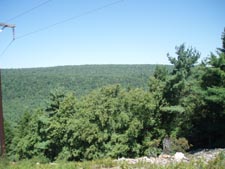
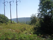
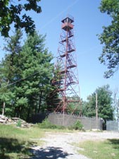
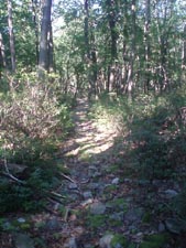
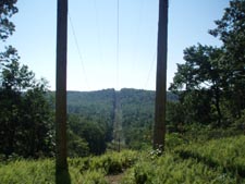
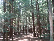
Trail Notes: From the parking area walk down the road crossing Rapid Run on a bridge below the dam. Turn left at the end of the guard rail following a wide gravel trail a short distance before turning left onto the orange blazed MST/Bake Oven Trail. The climb is steep as you soon cross a road. While the forest is mostly hardwood you will pass through dark copses of Hemlock and Pine. In 0.70 miles pass the junction with the Old Boundary Trail. Here the climb lessens dramatically. Pass a nice power line vista. In 1.47 miles from the Old Boundary trail cross Boyer Gap Road and begin climbing, less steeply this time, again. Pass the signed and blazed junction of the now invisible Buffalo Path on the right in 0.54 more miles. In another 0.81 miles the MST makes a hard left turn to cross Sand Mountain Road. Pass closely to its left an old lookout tower enclosed with razor wire. The trail descends steeply for the next 0.56 miles to the intersection with the red blazed Old Tram Trail. The trail soon forks with the left branch climbing back to Sand Mountain Road. You want to bear right to continue. In 0.68 miles arrive at the junction of the overgrown blue blazed Cracker Bridge trail. There might not be a sign. If you wish to camp out turn right onto it and cross Spruce run to find a nice campsite.
Continuing up the Old Tram trail soon cross the run on a couple bridges. Keep and eye out on the left for a small campsite and a large grassy area in the trees on the right. In another 0.69 miles you will realize where this trail got its name as you will traverse a 0.31 mile stretch containing the old railroad ballast used to support the ties and tracks of this narrow gauge lumber railroad. |
|
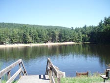
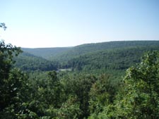
Pass the intersection with the blue blazed Rocky Corner Trail 0.59 miles further. The trail ends abruptly in 0.44 miles at another red blazed trail that parallels the power line you crossed earlier. This is the only confusing part of the hike. This old haul road is not signed but has a few red blazes on it. It is the Boiling Spring Tr and can be used to shorten the hike. To do the hike in its entirety turn left onto the road but in a few steps turn right following the cross country ski blazes out to the power line. Turn left onto it. In a few yards the trail will turn right back into the woods. This is the Overlook Trail. In 0.53 miles reach McCall Dam Road. Turn left and soon arrive at a nice view of R.B. Winter SP. The continuation of the Overlook Trail (now blazed yellow) is to the left of the fence. Descend quickly along switchbacks for 0.40 miles. Cross a road, following the signs for the Nature trail and Beach through a dense Hemlock grove. In 0.20 miles turn right towards the beach and in a few steps reach the terminus of the Boiling Spring trail on the left. (In season there are showers and rest rooms as well as fresh water and a concession stand at the beach.) Turn right to stay on the nature trail. After crossing a bridge or two watch for a narrow footpath that climbs up to RT192. The Park Headquarters is across the the road. If you parked near the dam turn left and walk back to your vehicle.
________________________________________
________________________________________ Outing Critiques Name: Michael Hike: Mid State Trail-Old Tram Trail Loop Date: 07/05/14 Rating: 3
Critique: This is a fairly nice hike, exhibiting typical central Pennsylvania terrain (ridge and valley, mountain laurel). Probably best done in early June when the mountain laurel is in bloom. We did the loop as a quick backpacking trip to try out some new gear and found that the trails (other than MST) are somewhat poorly maintained, though all trails described here were easily passable as of hike date. One MAJOR inaccuracy of this hike description is the absence of the described campsite at the junction of Old Tram and Cracker Bridge trails. We had planned on camping there, but when we reached the trail junction (no sign), we found that it was impossible to turn right onto the trail, as described. I took off my pack and bushwhacked in a ways finding a bridge, as though there had once been a path there, but it has truly and utterly disappeared. Continuing on along Old Tram trail, we did find a small campsite on the left after a short distance, as described. This site was basically "carved out" of the laurel and offered space for maybe one tent, but was a bit claustrophobic feeling with little available wood for a campfire (you'll need one to deter mosquitoes if nothing else). We passed up this site and found the grassy clearing on the right a little further along. You'll have to keep your eye out and walk off of the trail a few steps to the right before it opens up, but this is the largest laurel free and relatively rock-free space you will find on the hike. It is actually a beautiful grassy area with some tall trees, downed trees, and scattered rocks. There is a good space for one two person tent near the fire ring, which we rebuilt from an old one. There is probably space for one to two more tents, as well. Best of all, there is actually a bit of decent firewood in this clearing (otherwise hard to find in this hardwood/laurel/wet terrain). We left a few pieces stacked so as to stay dry near the fire ring ;) It is a decent, quick, overnight with an ok campsite (grassy area) if you want the trail to yourself... Plus, you can swim when you get back to the park! ________________________________________ |
|
|