|
Austin Mountain - Furnace Mountain Loop |
|
|
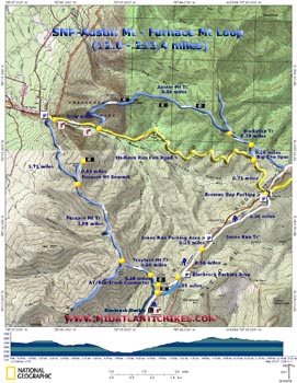
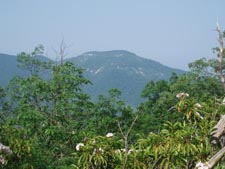
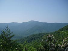
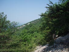
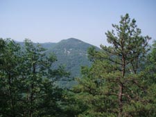
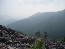
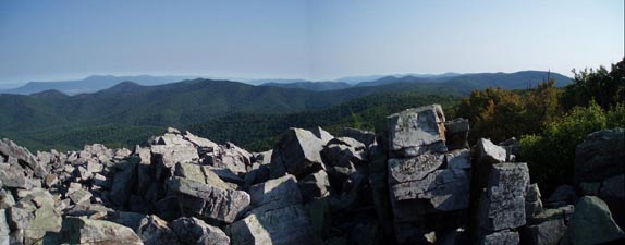
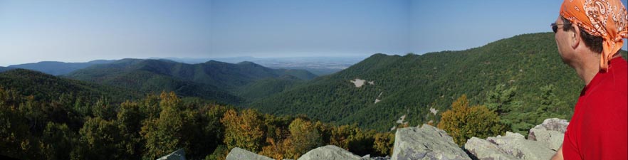
Description: The Southern District of the SNP has got to be my favorite area of the park to hike in. The trails on the west side of Skyline Drive offer a remoteness not found anywhere else in the park. Add to that some of the more extremely difficult and variable terrain in the area and you have yourself a very challenging yet rewarding trek. This is a 12.6 mile (13.4 if doing the out-and-back Furnace Mt Summit Trail) strenuous circuit with approximately 2600 feet of elevation gain and is for experienced hikers only. Terrain will range from mature woods to Mountain Laurel Tunnels (if hiked in June) to exposed talus slopes. Large sections of the trail are open to the sun. Wear sturdy boots and sun protection. Especially when hiking in the summer months bring extra water and allow plenty of time. On clear days grand views can be had all along the Austin Mountain Trail, the Furnace Mountain Summit and the infamous Blackrock area. |
|
Google Custom Driving Directions Note: Google Maps may use park fire roads that are closed to the public. Confirm your route with a real map. This hike starts in the Browns Gap Parking Area 0.1 mile north of Mile Post 83. ________________________________________ |
|
Zipped National Geographic. TOPO! GPS and Universal GPX Files |
Trail Notes: As the map indicates you can start the hike at four different parking areas (one at the western boundary of the park). We start at the Browns Gap Parking Area. From the parking area head west down the yellow blazed Madison Run Fire Road. In 0.71 miles turn right onto yellow blazed Big Run Spur. In 0.26 miles arrive at the junction with blue blazed Rockytop Trail. Turn left onto it and in 0.39 miles bear left at a fork onto blue blazed Austin Mountain Trail. Views of Furnace Mountain are had in between the Mountain Laurel tunnels. In 3.3 miles from the last trail junction descend to Madison Run Fire Road. Turn right and in 0.74 miles turn left onto blue blazed Furnace Mountain Trail and ford Madison Run. (This is your last chance to fill up with water if you brought a filter or chemicals to treat it.) Climb steadily up the western flank of Furnace Mountain. In 1.71 miles from the ford reach the Summit Spur. We did not do this out-and-back due to dense haze but I�ve been told it offers good views of Madison Run /Dundo Hollow and Austin Mountain (which you traversed earlier). Things never really quite flatten out until you reach Blackrock but the grade does eventually lessen considerably. In 2.09 miles reach the junction with Trayfoot Mountain Trail. Turn left and descend to the junction with the AT/Blackrock Spur in 0.26 miles on the left. Make this turn and soon pass through a slot in the rocks and arrive at Blackrock and the AT. Here you have two options. You can either turn right on the AT and then left on the continuation of the Trayfoot Mountain Trail then scramble up the backside of Blackrock for an almost 270 degree view. My preference is a careful frontal assault. Whichever you chose return to the previous trail junction and continue north on the AT. (Note: there was a fire along the northern section of Trayfoot Mountain Trail in the spring of 2008 making for a very unattractive walk. You will pass along the edge of it but there is no need to walk right down the middle of it.) |
|
In 0.35 miles come to a post on the right marking the Trayfoot Mountain Trail and the Blackrock Parking Area. This is about 75 yards down the old road. Continue straight on the AT and in 0.56 miles cross Skyline Drive. In 0.25 miles cross blue blazed Jones Run Trail, staying on the AT. Jones Run Parking is to the left. Pass side trails to the Dundo Group areas on the left and in 1.26 miles arrive at Skyline Drive and the Browns Gap parking area just across the road. ________________________________________
________________________________________
Name: Matthew
Culbertson
Hike: Austin Mountain - Furnace Mountain Loop
This is a really
beautiful hike filled with many magnificent views of the Page
and Shenandoah Valleys, Masanutten Mountain, the Madison Run
watershed, the mountains named in the hike, and of course the
main line of the Blue Ridge as you get far away from Skyline
Drive. ________________________________________
Name: Tony Van
Vugt
Hike: Austin-Furnace Mountain Loop ________________________________________
Name:
Blueridgetreks
Hike: Austin Mtn-Furnace Mtn Loop ________________________________________ |
|
|