|
Allegheny Trail Shuttle
|
|
|
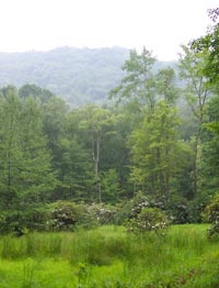
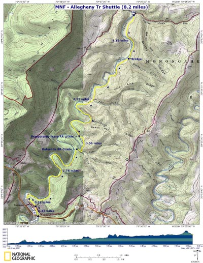
Description: The Allegheny Trail is a North/South 330 mile long backpackers delight. It's termini are on the PA/WV border (north) and at it's junction with the Appalachian Trail on Peter Mountain on the WV/VA border (south). While much of it follows the ridges there are stretches where the trail descends to river valleys to follow old railroad grades and beautiful rivers. Such a stretch runs between Rt72 on the north end and follows Glady Fork of the Cheat to where it leaves a joint rail trail ( The West Fork Trail) and turns back west to regain its place along the ridge. Since it runs north and south it crosses roads several times so setting up shuttles in this area are quite easy. This describes an eight mile shuttle between CO Rt12 where it crosses the Glady Fork out to US33 where that highway also crosses the fork. It is mostly an easy walk along a railroad grade except for one place where it climbs a hill to by-pass a long ago blowout of the grade and then finally dodges some private property just before the highway. Google Custom Directions to Car Drop-off on U.S. 33 There is a new gravel parking area on the north-west side of the Glady Fork Bridge. Google Custom Directions to Hike Start Cross Glady Fork on a small bridge and immediately turn right into a large gravel parking area. |
|
________________________________________ |
|
|
Trail Notes: From the parking area follow the Fork upriver, walking around a forest gate. The trail is blazed with yellow paint on the trees. Most of the time you will be on a railroad grade. Sometimes you'll see the Fork from the trail. Other times you may have to take short excursions on obvious but unmarked fisherman's trails to get a glimpse of Glady Fork. In 1.16 miles cross a wooden bridge over Brushy Creek. Continue along the RR grade for another 3.22 miles, crossing Five Lick Creek and Baker Hollow Run along the way. at the end of this stretch the RR grade suddenly ends. A blazed footpath takes over and climbs quickly up a hill and around a cove. It will descend but immediately climb again before coming down to regain the railroad grade. This stretch of what I call "Billy Goat trail" because of its narrowness is about 0.6 miles in duration. The rest of the hike is like the section before the climb. Continue following the RR grade. There are short sections where you'll leave the grade to cross streams only to regain the grade on the other side. In about 2.78 miles from the hill climb the RR grade will continue straight but you want to turn left onto a footpath that climbs up and over a short hill. Cross CO Rt5/18 and follow the trail out to US33. Turn right and follow the road back to your car. Printable/Downloadable Directions and Trail Notes
|
|
_______________________________________________________________________________ |
|
|